-
-
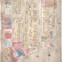
Title
-
Sanborn Map, Kansas City, Vol. 4, 1909-1950, Page p525
-
Description
-
A portion of Kansas City from W. 39th Street south to Westport Road and from Broadway east to Baltimore Avenue, showing buildings, streets, and additions. Large numbers at edges of page refer to page with adjoining area.
-
Date
-
1909/1950
-
Object Type
-
Map
-

-
Title
-
Baltimore Avenue Looking North from South of 39th Street
-
Description
-
View facing north along Baltimore Avenue from south of 39th Street in the Old Westport Residential District. Houses, apartment buildings and cars parked along Baltimore Avenue can be seen. The Alcazar Hotel can be seen on the west side of the street. A sign for Deluxe Laundry and Cleaners and the Calvary Baptist Church are in view on the east side of the street.
-
Date
-
1950~
-
Object Type
-
Photograph
-

-
Title
-
Sanborn Map, Kansas City, Vol. 4, 1909-1957, Page p525
-
Description
-
A portion of Kansas City from W. 39th Street south to W. 40th Street and from Broadway east to Baltimore Avenue, showing buildings, streets, and additions. Large numbers at edges of page refer to page with adjoining area.
-
Date
-
1909/1957
-
Object Type
-
Map
-

-
Title
-
3910 Main Street
-
Description
-
Photograph of a vacant building at 3910 Main Street, circa 1983. The building was originally a Denny's restaurant that closed in 1982. Rosie's Bakery and Deli opened in the building in 1983. Foolkiller Theater, on the northwest corner of 39th and Main, can be seen in the background of the image. The restaurant building and gas station to the north were demolished in 1998.
-
Date
-
1983~
-
Object Type
-
Photograph
