-
-
Title
-
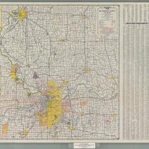
Kansas City and Vicinity
-
Description
-
Road map of Kansas City and surrounding counties including Ray and Buchanan counties in Missouri, Johnson and Leavenworth counties in Kansas; enlarged maps of St. Joseph, Mo. and Leavenworth, Kan. inset. Reverse side is street map of metropolitan Kansas City. Includes indexes to towns, airports, golf clubs, cemeteries, parks, lakes, and streets.
-
Date
-
1960
-
Object Type
-
Map
-
-
Title
-
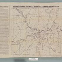
Historical Landmarks, Trails & Monuments in and around Kansas City, Missouri
-
Description
-
Map created for the American Pioneer Trails Association with historical data provided by the Native Sons of Kansas City, Missouri, showing the locations of historical landmarks in the area. A Kawsmouth Chronology printed on the left hand side of the map provides a list of important dates in Kansas City history.
-
Date
-
1938
-
Object Type
-
Map
-

-
Title
-
SC25 Kickapoo Reservation Survey Field Notes Finding Aid
-
Description
-
This collection consists of eight pages of handwritten notes describing a survey for the demarcation of Indian reservations in what are now Doniphan, Atchison, and Leavenworth counties in northeastern Kansas. Notes include a brief description of the survey's purpose, Public Land Surveying System (PLSS) township-range-section location data, surveyors' measurements, and physical descriptions of the benchmarks, landmarks, and monuments used by the surveyor. Pages are unnumbered.
-
Date
-
1854~
-
Object Type
-
Finding Aid
