Pages
-

-
Title
-
Blue Valley Industrial District
-
Description
-
Aerial view looking north shows the Blue River, also known as the Big Blue, cutting through the center of the image, with 12th Street crossing over. The left foreground of the image shows The Ruberoid Co., manufacturers of asphalt and asbestos building materials. To the north is Black Sivalls & Bryson Inc., makers of steel products. North of the bridge, in the current location of Interstate 435, is the Centropolis Crusher, a facility for rock crushing. Standard Oil Co. refinery at Sugar Creek is visible in the far background. The Olympic Stadium Midget Auto Racetrack at 7900 Truman Road is visible south of 12th Street and east of the river. As of 2010, the Olympic Stadium site is now home to Pick-n-Pull used auto parts lot. The Standard Oil Refinery, later Amoco Oil Company, closed in the 1980s.
-
Date
-
1962-11-20
-
Object Type
-
Negative
-

-
Title
-
Blue Valley Industrial District
-
Description
-
Aerial view looking north shows the Blue River, also known as the Big Blue, cutting through the center of the image, with 12th Street crossing over. In the left foreground, a portion of The Ruberoid Co. (manufacturers of asphalt and asbestos building materials) is visible. Just north of that is the parking lot of Black Sivalls & Bryson Inc. (makers of steel products). North of the bridge, in the current location of Interstate 435, is the Centropolis Crusher, a facility for rock crushing. Just out of sight on the south of 12th and east of Blue River is the Olympic Stadium Midget Auto Racetrack.
-
Date
-
1962-11-20
-
Object Type
-
Negative
-

-
Title
-
Sheffield Steel Company
-
Description
-
Aerial view, looking south, of company and grounds.
-
Date
-
1955
-
Object Type
-
Photograph
-

-
Title
-
Sheffield Steel Company
-
Description
-
Aerial view, looking southeast, of company and grounds; also shows Big Blue River.
-
Date
-
1955
-
Object Type
-
Photograph
-
-
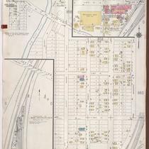
Title
-
Sanborn Map, Kansas City, Vol. 6, 1917-1957, Page p859
-
Description
-
A portion of Leeds, Missouri, from E. 37th Street south to E. 40th Street and from Belmont Avenue east to Bennington Avenue, showing buildings, streets, and additions. Large numbers at edges of page refer to page with adjoining area. Noted at top of map, "(705-706-722-Vol. 5) Add'l Sheet, Nov. 1939."
-
Date
-
1917/1957
-
Object Type
-
Map
-
-
Title
-
Sanborn Map, Kansas City, Vol. 5, 1940-1941, Page p1216
-
Description
-
A portion of Kansas City from the Big Blue River south to E. 24th Street and from the Saint Louis and San Francisco Railroad east to Tullis Avenue, showing buildings and streets. Large numbers at edges of page refer to page with adjoining area. Indicated at top of sheet that this page number corresponds with pages 707, 710 and 722 in Vol. 5, 1909-1938.
-
Date
-
1940/1941
-
Object Type
-
Map
-

-
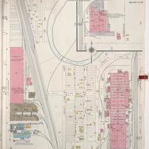
Title
-
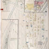
Sanborn Map, Kansas City, Vol. 5, 1940-1941, Page p0645
-
Description
-
A portion of Kansas City just north of the intersection of Bristol Avenue and E. 6th Street, showing buildings, railroads and streets. Large numbers at edges of page refer to page with adjoining area. Indicated at top of sheet that this page number corresponds with pages 689, 690, and 692 in Vol. 5, 1909-1938.
-
Date
-
1940/1941
-
Object Type
-
Map
-
-
Title
-
Sanborn Map, Kansas City, Vol. 5, 1940-1941, Page p0646
-
Description
-
A portion of Kansas City just north of the intersection of Wilson and Manchester Avenue, showing buildings, railroads, and streets. Large numbers at edges of page refer to page with adjoining area. Indicated at top of sheet that this page number corresponds with pages 703, 704, 711, and 723 in Vol. 5, 1909-1938.
-
Date
-
1940/1941
-
Object Type
-
Map
-

-
Title
-
Sanborn Map, Kansas City, Vol. 5, 1940-1941, Page p1236
-
Description
-
A portion of Kansas City from E. 18th Street south to E. 20th Street and from Bennington Avenue east to Winchester Avenue and a portion from E. 24th Street south to E. 27th Street and Lawndale Avenue east to Belmont Avenue, showing buildings and streets. Large numbers at edges of page refer to page with adjoining area. Indicated at top of sheet that this page number corresponds with pages 751 and 756 in Vol. 6.
-
Date
-
1940/1941
-
Object Type
-
Map
-

-
Title
-
Sanborn Map, Kansas City, Vol. 5, 1940-1941, Page p1214
-
Description
-
A portion of Kansas City from E. 15th Street south to E. 18th Street and from Crystal Avenue east to Winchester Avenue, showing buildings and streets. Large numbers at edges of page refer to page with adjoining area. Indicated at top of sheet that this page number corresponds with pages 698 and 700-702 in Vol. 5, 1909-1938.
-
Date
-
1940/1941
-
Object Type
-
Map
-

-
Title
-
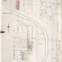
Sanborn Map, Kansas City, Vol. 5, 1940-1941, Page p0644
-
Description
-
A portion of Kansas City from St. John Avenue south to Wilson Avenue and from Bennington Avenue east to Cambridge Avenue, showing buildings, railroads, and streets. Large numbers at edges of page refer to page with adjoining area. Indicated at top of sheet that this page number corresponds with pages 603, 613, 687, 689, 695 and 711 in Vol. 5, 1909-1938.
-
Date
-
1940/1941
-
Object Type
-
Map
-

-
Title
-
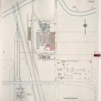
Sanborn Map, Kansas City, Vol. 5, 1940-1941, Page p0607
-
Description
-
A portion of Kansas City from E. 12th Street south to E. 15th Street and from Bristol Avenue east to Manchester Avenue, showing buildings, streets, and railroad lines. Large numbers at edges of page refer to page with adjoining area. Indicated at top of sheet that this page number corresponds with pages 696, 698, 701, and 710 in Vol. 5, 1909-1938.
-
Date
-
1940/1941
-
Object Type
-
Map
-
-
Title
-
Sanborn Map, Kansas City, Vol. 5, 1940-1941, Page p1215
-
Description
-
A portion of Kansas City from E. 15th Street south to E. 19th Street and from Manchester Avenue east to Ashland Avenue, showing buildings and streets. Large numbers at edges of page refer to page with adjoining area. Indicated at top of sheet that this page number corresponds with pages 652, 707 and 710 in Vol. 5, 1909-1938.
-
Date
-
1940/1941
-
Object Type
-
Map
-
-
Title
-
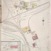
Sanborn Map, Kansas City, Vol. 5, 1940-1941, Page p0614
-
Description
-
A portion of Kansas City from E. 6th Street south to E. 12th Street and from Winchester Avenue east to Eastern Avenue, showing buildings, railroads, and streets. Large numbers at edges of page refer to page with adjoining area. Indicated at top of sheet that this page number corresponds with pages 696, 699, 703, and 709 in Vol. 5, 1909-1938.
-
Date
-
1940/1941
-
Object Type
-
Map
-

-
Title
-
Aerial View of Kansas City, Missouri
-
Description
-
Aerial photograph of one square mile of Kansas City, Missouri showing the area south of Blue Valley Park including parts of Interstate 70 and Highway 40, the railroad, and Big Blue River. Map identified from set as Section 13, Township 49N, Range 33W, S-59.
-
Date
-
1964-04
-
Object Type
-
Map
-

-
Title
-
Geologic Cross Sections of Kansas City and Jackson County
-
Description
-
Six cross sections of areas of Jackson County, Missouri, and Kansas City, Missouri, illustrate altitude above sea level and types of bedrock. Labels display locations of creeks and rivers, as well as major city thoroughfares including Southwest Boulevard, Armour Boulevard, and 75th Street.
-
Object Type
-
Map
-
-
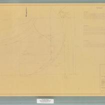
Title
-
Kansas City Municipal Farm
-
Description
-
Map and legal description of the Kansas City Municipal Farm. Map includes boundaries, details of the Kansas City Southern Railway right-of-way, and text of legal descriptions of three tracts of the farm property.
-
Date
-
1967-03-22
-
Object Type
-
Map
-
-
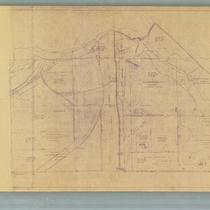
Title
-
Map of Grounds, Kansas City Municipal Farm
-
Description
-
Detailed map of the grounds of the Kansas City Municipal Farm. The map includes diagrams of buildings, streams, roads, Interstate 435, and the Kansas City Southern Railway. The deed citations for each tract of land comprising the grounds of the farm, as well as the year acquired, are included as map details.
-
Date
-
1964
-
Object Type
-
Map
-
-
Title
-
Sanborn Map, Kansas City, Vol. 6, 1917-1945, Page p859
-
Description
-
A portion of Leeds, Missouri, from E. 37th Street south to E. 40th Street and from Belmont Avenue east to Bennington Avenue, showing buildings, streets, and additions. Large numbers at edges of page refer to page with adjoining area. At top of map, "(705-706-722-Vol. 5) Add'l Sheet, Nov. 1939."
-
Date
-
1939
-
Object Type
-
Map
Pages
