-
-
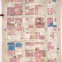
Title
-
Sanborn Map, Kansas City, Vol. 2, 1909-1937, Page p213
-
Description
-
A portion of Kansas City from E. 8th Street south to E. 11th Street and from Holmes east to Campbell, showing buildings, streets, and additions. Large numbers at edges of page refer to page with adjoining area.
-
Date
-
1909/1937
-
Object Type
-
Map
-
-
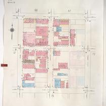
Title
-
Sanborn Map, Kansas City, Vol. 1, 1939-1958, Page p071
-
Description
-
A portion of Kansas City from E. 8th Street south to E. 10th Street and from Holmes Street east to Campbell Street, showing buildings and streets. Large numbers at edges of page refer to page with adjoining area.
-
Date
-
1939/1958
-
Object Type
-
Map
-
-
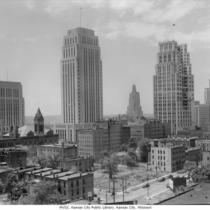
Title
-
Downtown Kansas City Skyline
-
Description
-
View looking toward the southwest of a portion of the eastern side of downtown Kansas City, Missouri. Photo taken from the Chase Hotel around 9th and Holmes. Buildings in view include from left to right: Jackson County Courthouse, City Hall, Kansas City Power and Light Building and Telephone Building. A portion of the old Central High School/Junior College located on the corner of 11th and Locust can be seen on the left. Also the Schuyler Hotel and Drake Hotel are in view.
-
Date
-
1940~
-
Object Type
-
Negative
-

-
Title
-
Northeast from City Hall
-
Description
-
View facing northeast taken from City Hall located at 414 E. 12th Street. The Chase Hotel, the northeast corner of the downtown expressway loop, Columbus Park, the Missouri River, and other downtown buildings can be seen.
-
Object Type
-
Photograph
-

-
Title
-
6th and Southeast Trafficway
-
Description
-
View facing northeast taken from City Hall located at 414 E. 12th Street. The Chase Hotel, the northeast corner of the downtown expressway loop, Columbus Park, the Missouri River, and other downtown buildings can be seen.
-
Date
-
1961-09-07
-
Object Type
-
Photograph
