-
-
Title
-
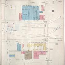
Sanborn Map, Kansas City, Vol. 1A, 1939-1949, Page p148
-
Description
-
A portion of Kansas City from W. 25th Street south to W. 26th Street and from Madison Avenue east to W. Pennway, showing buildings and streets. Large numbers at edges of page refer to page with adjoining area.
-
Date
-
1939/1949
-
Object Type
-
Map
-

-
Title
-
Sanborn Map, Kansas City, Vol. 1, 1909-1938, Page p083
-
Description
-
A portion of Kansas City from W. 25th Street south to W. 26th Street and from Jefferson east to Broadway, showing buildings, streets, and additions. Large numbers at edges of page refer to page with adjoining area.
-
Date
-
1909/1938
-
Object Type
-
Map
-

-
Title
-
2540 West Pennway Street
-
Description
-
Photograph of architectural details on a commercial building at 2540 West Pennway circa 1980. National Store Fixture Company, a building tenant at the time of the photograph, declared bankruptcy in 1983 and the building was sold to a developer in 1984. The building was formerly a bottling factory and warehouse for Coca-Cola.
-
Date
-
1980~/1989~
-
Object Type
-
Photograph
