Pages
-

-
Title
-
History of Clay and Platte Counties, Missouri
-
Description
-
History of Harlem, Missouri, "in the extreme southwestern part of the [Gallatin] township, on the north bank of the Missouri, immediately across the river from Kansas City," in North Kansas City, Clay County. A description of its origin with the railroads and regular flooding until after the flood of 1881 is provided.
-
Date
-
1885
-
Object Type
-
Book
-

-
Title
-
Life on the Missouri's Banks in the Shadow of Kansas City
-
Description
-
Article describing the Missouri River-side neighborhood of Harlem in North Kansas City and its "unfamiliar world" between the Hannibal and A. S. B. Bridges, composed of boatmen, unemployed, fishermen in houseboats, and scrap shacks.
-
Date
-
1938-03-10
-
Object Type
-
Newspaper Article
-

-
Title
-
Aerial View of Missouri River at Kansas City
-
Description
-
Aerial view of Missouri River at Kansas City looking west showing the three bridges-ASB, Paseo, and Broadway-and Municipal Airport as well as the riverfront and water works. It also shows former Harlem immediately east of the airport and portions of North Kansas City, Missouri. No print image; negative and digital only.
-
Object Type
-
Negative
-

-
Title
-
Harlem Afternoon
-
Description
-
Article about the village of Harlem, Missouri, on the north side of the Missouri River across from Kansas City in North Kansas City. Interview of "Captain Kade," former pilot of the Annie Cade ferryboat during the 1903 flood.
-
Date
-
1935-02-01
-
Object Type
-
Magazine Article
-
-
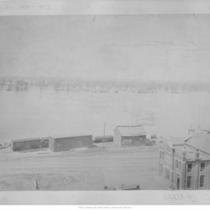
Title
-
Flood Scene
-
Description
-
View looking north from south side of Missouri River toward Harlem in Clay County; also shows V. Baltz Brewery.
-
Date
-
1881
-
Object Type
-
Photograph
-

-
Title
-
Ferryboats, Fishing: Old Times Echo Softly in Harlem
-
Description
-
Photos, map, and article about the town or community of Harlem, Missouri, on the north bank of the Missouri River (Clay County) across from Downtown Kansas City (Jackson County), "bounded by the A.-S.-B. and Hannibal bridges, the Missouri River levee and the south city limits of North Kansas City." Description of the district's history of decine in population since the construction of the Hannibal Bridge in the 1860s, past fishing and ferryboat economy, old-time residents such as police officer Dick Dawson, and introduction of sewers and other utilities upon annexation into the city of Kansas City, Missouri, etc.
-
Date
-
1973-07-08
-
Object Type
-
Newspaper Article
-

-
Title
-
Flood Scene
-
Description
-
View looking north from south side of Missouri River toward Harlem in Clay County; also shows V. Baltz Brewery.
-
Date
-
1881
-
Object Type
-
Photograph
-

-
Title
-
Bird's Eye View - Kansas City
-
Description
-
Pictorial map showing the cities and towns of Kansas City, Missouri; Harlem, Missouri; Westport, Missouri; Rosedale, Kansas; Argentine, Kansas; Armourdale, Kansas; Armstrong, Kansas; Riverview, Kansas; Kansas City, Kansas; and Wyandotte, Kansas. At the time of its publication, the map had an extensive key listing the numbered buildings, most of which has been removed. Steamboats traveling along the Missouri River can be seen. The map displays the steep bluffs and topography of the region. It also indicates Kansas City's expansion southward away from the Missouri River, the development of the stockyards industry in the West Bottoms and interconnectivity with the surrounding cities and towns that followed completion of the Hannibal Bridge in 1869.
-
Date
-
1885~
-
Object Type
-
Map
-

-
Title
-
Map of the Vicinity of Kansas City in Kansas and Missouri
-
Description
-
Street map of the two Kansas Cities. Only main streets are named. Map includes surrounding areas, among which are Harlem, Independence, Randolph City, Westport, Shawnee, Argentine, Rosedale, and Quindaro. Townships are indicated by color. At top of map, "Presented by the 'Kansas City Times,' January 1st, 1888."
-
Date
-
1888
-
Object Type
-
Map
-

-
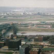
Title
-
Municipal Airport and Downtown Skyline
-
Description
-
Aerial view looking south to downtown Kansas City showing Municipal Airport terminal buildings and parking lot. Airplanes sit on the taxiway. The Broadway Bridge spans the Missouri River on the right. The Harlem neighborhood north of the Missouri River can also be seen. Airport was later renamed Charles B. Wheeler Downtown Airport.
-
Date
-
1960~
-
Object Type
-
Negative
-

-
Title
-
Sanborn Map, Kansas City, Vol. 3, 1896-1907, Page p354
-
Description
-
Northern part of early Kansas City in Harlem, Missouri (Clay County), from Second Street south to First Street and from Bridge Street east to Oak Street, showing buildings and streets. Large numbers at edges of page refer to page with adjoining area.
-
Date
-
1896/1907
-
Object Type
-
Map
-

-
Title
-
Map Showing the Location of the Kansas City Bridge
-
Description
-
Map showing the location of the Hannibal Bridge, as well as the surrounding communities of Harlem, Wyandott, West Kansas and early Kansas City. The map shows the location of the southern bank of the Missouri River when the area was first surveyed in 1826 and indicates the rail lines connecting to the bridge.
-
Object Type
-
Map
-

-
Title
-
Map of Greater Kansas City and Suburbs
-
Description
-
Street map of Kansas City area, including Rosedale and Kansas City, Kansas; North Kansas City, Independence, and Mount Washington in Missouri. Shows classes of roads, railroad lines, and streetcar lines as well as clubs and cemeteries. Includes index to streets and streetcar lines.
-
Date
-
1912
-
Object Type
-
Map
-

-
Title
-
Steamboats
-
Description
-
Scrapbook information on steamboat revivals in Harlem, Missouri, and other old steamboats.
-
Object Type
-
Archival Material
-

-
Title
-
Bird's Eye View of Early Kansas City
-
Description
-
Unframed, mounted photograph (20 in. x 40 in.) of a bird's eye view map drawing, location of original unknown. Image extends from the bend in the Missouri River just below the confluence of the Missouri and Kansas Rivers to about Woodland Avenue and from the Harlem area just north of the river to about 20th Street. The West Bottoms are fully shown as well as an island in the river. Riverboats are in view as is the Hannibal Bridge. Street names are given but image is blurry and unreadable.
-
Date
-
1885~
-
Object Type
-
Archival Material
-

-
Title
-
Downtown Skyline from Harlem
-
Description
-
Photograph of downtown skyline taken from the Harlem area of Kansas City north of the Missouri River. A house and other smaller buildings can be seen in the foreground. The Hannibal Bridge is in view on the right hand side of the image.
-
Date
-
1940~/1949~
-
Object Type
-
Photograph
-
-
Title
-
Municipal and Fairfax Airports from Commerce Tower
-
Description
-
View facing northeast from the balcony of the Commerce Towers Building at 911 Main Street. The River Market, the Missouri River, the Heart of America Bridge, the Hannibal Bridge, the Municipal Airport, the Fairfax Airport, Harlem, and other downtown buildings are in view.
-
Date
-
1965-04-22
-
Object Type
-
Photograph
-
-
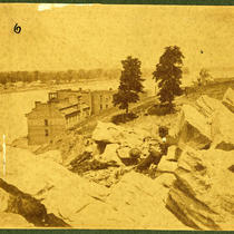
Title
-
Gillis House Hotel and Missouri River
-
Description
-
View looking northeast from a hill southwest of the Gillis House Hotel. An individual seated among rocks at the top of the hill and buildings across the river in Harlem can be seen.
-
Date
-
1869
-
Object Type
-
Photograph
-

-
Title
-
Map of the City of Kansas - Jackson County, Missouri
-
Description
-
Map of the City of Kansas, later known as Kansas City, in Jackson County, Missouri. Major streets, railroad lines, additions and subdivisions are marked. Landmarks and significant buildings are labeled. Harlem on the north side of the Missouri River in Clay County, Missouri, is shown.
-
Date
-
1880
-
Object Type
-
Map
Pages
