-

-
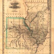
Title
-
Partie des Etats-Unis
-
Description
-
Early map of Missouri and Illinois, apparently from a French atlas. Much of what is now eastern Kansas is also included, along with small sections of Kentucky and Tennessee. An early organization of Missouri counties is in evidence, including Lillard County. Some early trails/exploration routes are indicated, as well as locations of mineral resources. Some Indian villages are indicated in the Kansas portion, with estimated populations. The etablissment de Chouteau on the Osage River is featured.
-
Date
-
1825
-
Object Type
-
Map
-

-
Title
-
Illinois
-
Description
-
Topographical map of the state of Illinois illustrating geographic features of the state, including lakes and rivers. Map also depicts locks along the Mississippi and Ohio Rivers, as well as cities including Chicago, Decatur, Rockford, Springfield, and East St. Louis. Prepared by Allan Cartography, Medford, OR. Printed by The Pikes Peak Lithographic Co., Colorado Springs, CO. Copyright Raven Maps & Images.
-
Date
-
1998
-
Object Type
-
Map
-
-
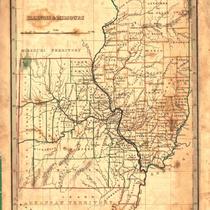
Title
-
Illinois and Missouri
-
Description
-
Map of Illinois and Missouri showing towns, rivers, and mountains. Some areas labeled Military bounty lands.
-
Date
-
1823
-
Object Type
-
Map
-

-
Title
-
Continental Oil Co. Official Road Map of Missouri
-
Description
-
Road map of Missouri showing the state highway system and the various type of roads within that system, as well as cities and towns according to population. Map also shows small portions of states bordering Missouri and larger portions of Illinois and Kansas. The reverse side of the map shows a small Continental Oil Co. Road Map of the United States including a key to National Parks and Monuments. Also included is a list of Continental Oil Company Service Station locations throughout the country.
-
Object Type
-
Map
-

-
Title
-
Illinois and Missouri
-
Description
-
Color shaded map of Illinois and Missouri showing roads, towns, counties, forts, public houses, etc.
-
Date
-
1823
-
Object Type
-
Map
-

-
Title
-
Missouri, Illinois, and Iowa
-
Description
-
Map of Missouri, Illinois and the southeast corner of Iowa showing counties, towns, rivers and railroads.
-
Date
-
1843
-
Object Type
-
Map
-
-
Title
-
Illinois & Missouri
-
Description
-
Map of Missouri and Illinois showing counties, towns, and rivers. Also shows the path of the Illinois and Michigan Railroad in northern Illinois.
-
Date
-
1835
-
Object Type
-
Map
-

-
Title
-
The Contest Over Slavery Between Illinois and Missouri
-
Description
-
Although Illinois and Missouri were adjacent to each other, they had differing views on the question of slavery. Illinois was mainly settled by Northerners and actively worked against the early slave laws in the state. Missouri was settled largely by Southerners and had a more Southern mentality even though slaves were not used in Missouri in the same way as in the deep South. Article discusses various legislation in both states toward the question of slavery and the work of abolitionists.
-
Date
-
1943-07
-
Object Type
-
Magazine Article
-

-
Title
-
St. Clair Railroad
-
Description
-
Map showing the St. Clair Railroad in an area slightly east of St. Louis in Illinois.
-
Object Type
-
Map
-

-
Title
-
Shell Official Road Map of Missouri
-
Description
-
Road map of Missouri showing the state highway system and the various types of roads within that system, as well as state parks, points of interest, airports, and populations of cities and towns. Map also includes small portions of states bordering Missouri; a significant portion of southern Illinois including the cities of Springfield, Evansville; and part of Kansas as far west as Emporia. The reverse side of the map shows a Shell Transcontinental Mileage Chart and an Official Road Map of the United States. Also included are National Parks and monuments in the United States and Canada.
-
Date
-
1935
-
Object Type
-
Map
-

-
Title
-
Special French Heritage Issue
-
Description
-
The whole issue is devoted to various topics relating to the French founding fathers of the areas in the Louisiana Purchase, including the Chouteaus in St. Louis and Kansas City. Articles include the following: "A Place Beyond Words, Using the Creole Corridor to Redefine the Terms of Early American History;" "Determine l'Effacement, The French Creole Cultural Zone in the American Heartland;" "From Missouri to West Point, Native Sons of Upper Louisiana;" "'Contrary to Good Order,' Political Culture in the Illinois Country Under the French Regime;" "Sui Generis, Landscape, Community, and Mentalite in the Illinois Country;" and "The Ghost Horse Site, Pierre Laclede's First Residence in the Illinois Country?"
-
Date
-
2010
-
Object Type
-
Magazine
