-

-
Title
-
Triangle Trauma Will Soon Fade
-
Description
-
Illustration and article about the changes to the Grandview Triangle, a "sea of congestion where Interstate 470, Interstate 435 and U.S. 71 converge in southeast Kansas City." In 2005 the Missouri General Assembly bestowed a new title for the Triangle: "'Three Trails Crossing Memorial Highway." Also includes a chart "By the Numbers."
-
Date
-
2007-12-13
-
Object Type
-
Newspaper Article
-

-
Title
-
We can See the Future from Here
-
Description
-
Article on redesign project for Grandview Triangle provides facts and figures for the reconfiguration of the notorious intersection of Interstates 435 and 470 and U.S. 71.
-
Date
-
2004-11-06
-
Object Type
-
Newspaper Article
-

-
Title
-
Work to Begin on Uncorking the I-435 Bottleneck
-
Description
-
Article discusses and lists the work ''on a $165 million project intended to break the increasing number of traffic jams on Interstate 435 between Metcalf Avenue and U.S. 60, ranked as the second-most-heavily traveled stretch of highway in Kansas.''
-
Date
-
2005-09-06
-
Object Type
-
Newspaper Article
-
-
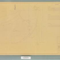
Title
-
Kansas City Municipal Farm
-
Description
-
Map and legal description of the Kansas City Municipal Farm. Map includes boundaries, details of the Kansas City Southern Railway right-of-way, and text of legal descriptions of three tracts of the farm property.
-
Date
-
1967-03-22
-
Object Type
-
Map
-
-
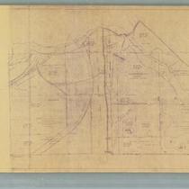
Title
-
Map of Grounds, Kansas City Municipal Farm
-
Description
-
Detailed map of the grounds of the Kansas City Municipal Farm. The map includes diagrams of buildings, streams, roads, Interstate 435, and the Kansas City Southern Railway. The deed citations for each tract of land comprising the grounds of the farm, as well as the year acquired, are included as map details.
-
Date
-
1964
-
Object Type
-
Map
-

-
Title
-
The Unplanned City
-
Description
-
Brief history of city planning in Kansas City, contrasting the first half of the 20th century with plans by J. C. Nichols to the second half with lack of planning and a donut effect around the metro area created by the interstate system.
-
Date
-
2001-01
-
Object Type
-
Magazine Article
-

-
Title
-
Metropolitan Kansas City: Industrial Map
-
Description
-
A map of the Kansas City metropolitan area, color-coded to indicate light industry areas, heavy industry areas, switching limits, commercial zones, and public lands. Map also shows major roads and highways, towns, bodies of water, airports, and selected railroads. Planned extensions of Interstate 435 through the west side of the metropolitan area and north of Interstates 29 and 35, of U.S. highway 71 through midtown Kansas City, of route T, and of Interstate 470 are also depicted. Map includes radial circles of five mile intervals, centered on downtown Kansas City.
-
Date
-
1970
-
Object Type
-
Map
-

-
Title
-
Map of Inter-City
-
Description
-
Hand-drawn map of area from proposed I-435 east to River Blvd., and from 23rd Street north to Sugar Creek. Cemeteries and parks are noted. Map appeared in the newspaper "Inter-City News" on March 22, 1968. Includes street legend.
-
Date
-
1968
-
Object Type
-
Map
