Pages
-

-
Title
-
James Crockett
-
Description
-
File contains one biographical article with photo about James Crockett, owner of Alpha Machine Works at 1649 Jarboe Street. The article is from The Kansas City Star (May 17, 1971), entitled �??Clicks with Machine Shop as Persistence Pays Off�?� by Janet Meyer. According to Crockett, he was �??the only black man doing this work in Kansas City�?� at the time.
-
Object Type
-
Vertical File
-
-
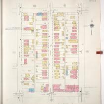
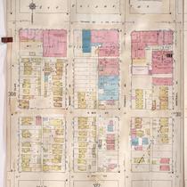
Title
-
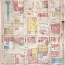
Sanborn Map, Kansas City, Vol. 3, 1909-1957, Page p316
-
Description
-
A portion of Kansas City from E. 17th Street south to E. 19th Street and from Charlotte east to Harrison, showing buildings, streets, and additions. Large numbers at edges of page refer to page with adjoining area.
-
Date
-
1909/1957
-
Object Type
-
Map
-
-
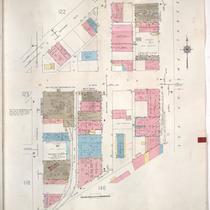
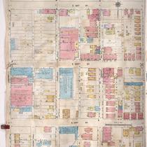
Title
-
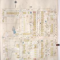
Sanborn Map, Kansas City, Vol. 3, 1909-1957, Page p340
-
Description
-
A portion of Kansas City from E. 19th Street south to E. 21st Street and from Bales Avenue east to Cleveland Avenue, showing buildings, streets, and additions. Large numbers at edges of page refer to page with adjoining area.
-
Date
-
1909/1957
-
Object Type
-
Map
-
-
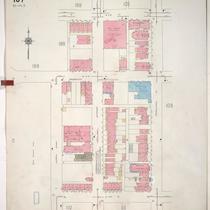
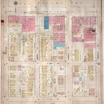
Title
-
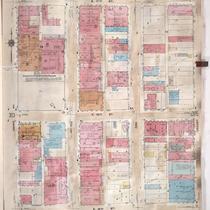
Sanborn Map, Kansas City, Vol. 3, 1909-1957, Page p314
-
Description
-
A portion of Kansas City from E. 17th Street south to E. 19th Street and from Grand Avenue east to Locust, showing buildings, streets, and additions. Large numbers at edges of page refer to page with adjoining area.
-
Date
-
1909/1957
-
Object Type
-
Map
-
-
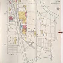
Title
-
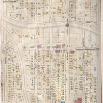
Sanborn Map, Kansas City, Vol. 6, 1917-1957, Page p837
-
Description
-
A portion of the Intercity District connecting Kansas City, Missouri, and Independence, Missouri, from Morrell Avenue south to Independence Avenue and from Brookside Drive east to Overton Avenue, showing buildings, streets, and additions. Large numbers at edges of page refer to page with adjoining area.
-
Date
-
1917/1957
-
Object Type
-
Map
-
-
Title
-
Sanborn Map, Kansas City, Vol. 1A, 1939-1949, Page p114
-
Description
-
A portion of Kansas City from W. 16th Street south to W. 17th Street and from Belleview Avenue east to Summit, showing buildings and streets. Large numbers at edges of page refer to page with adjoining area.
-
Date
-
1939/1949
-
Object Type
-
Map
-
-
Title
-
Sanborn Map, Kansas City, Vol. 1A, 1939-1949, Page p124
-
Description
-
A portion of Kansas City from W. 19th Street south to W. 22nd Street and from Wyandotte east to Main Street, showing buildings and streets. Large numbers at edges of page refer to page with adjoining area.
-
Date
-
1939/1949
-
Object Type
-
Map
-
-
Title
-
Sanborn Map, Kansas City, Vol. 1A, 1939-1949, Page p107
-
Description
-
A portion of Kansas City from W. 11th Street south to W. 13th Street and from Summit east to Pennsylvania Avenue, showing buildings and streets. Large numbers at edges of page refer to page with adjoining area.
-
Date
-
1939/1949
-
Object Type
-
Map
-
-
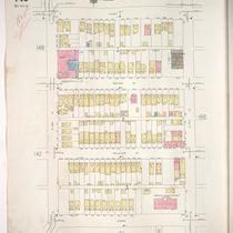
Title
-
Sanborn Map, Kansas City, Vol. 1A, 1939-1949, Page p149
-
Description
-
A portion of Kansas City from W. 26th Street south to W. 27th Street and from Jarboe Street east to Summit Street, showing buildings and streets. Large numbers at edges of page refer to page with adjoining area. Handwritten at top of page in red, "Negro Section."
-
Date
-
1939/1949
-
Object Type
-
Map
-
-
Title
-
Sanborn Map, Kansas City, Vol. 5, 1940-1941, Page p0630
-
Description
-
A portion of Kansas City from Wilson Avenue south to E. 8th Street and from Fuller Avenue east to Winchester Avenue, showing buildings and streets. Large numbers at edges of page refer to page with adjoining area. Top of sheet indicates that this page number corresponds with pages 687, 688, 691, 692 and 693 in Vol. 5, 1909-1938.
-
Date
-
1940/1941
-
Object Type
-
Map
-

-
Title
-
Sanborn Map, Kansas City, Vol. 1A, 1939-1949, Page p101
-
Description
-
A portion of Kansas City from W. 3rd Street south to W. 5th Street and from Bluff Street east to Broadway, showing buildings, streets, and railroad lines. Large numbers at edges of page refer to page with adjoining area.
-
Date
-
1939/1949
-
Object Type
-
Map
-

-
Title
-
Sanborn Map, Kansas City, Vol. 2, 1940-1957, Page p238
-
Description
-
A portion of northeast Kansas City from E. 11th Street south to Truman Road and from Cleveland Avenue east to Spruce Avenue, showing buildings, streets, and railroad lines. Large numbers at edges of pages refer to page with adjoining area.
-
Date
-
1940/1957
-
Object Type
-
Map
-
-
Title
-
Sanborn Map, Kansas City, Vol. 2, 1940-1957, Page p205
-
Description
-
A portion of northeast Kansas City from E. 13th Street south to Truman Road and from Prospect Avenue east to Chestnut Avenue, showing buildings and streets. Large numbers at edges of page refer to page with adjoining area.
-
Date
-
1940/1957
-
Object Type
-
Map
-

-
Title
-
Sanborn Map, Kansas City, Vol. 1A, 1939-1949, Page p139
-
Description
-
A portion of Kansas City from W. 23rd Street Trafficway south to W. 25th Street and from Fairmount Street east to Mercier Street, showing buildings and streets. Large numbers at edges of page refer to page with adjoining area.
-
Date
-
1939/1949
-
Object Type
-
Map
-
-
Title
-
Sanborn Map, Kansas City, Vol. 1A, 1939-1949, Page p154
-
Description
-
A portion of Kansas City from W. 28th Street south to W. 29th Street and from Terrace Street east to Jarboe Street, showing buildings and streets. Large numbers at edges of page refer to page with adjoining area.
-
Date
-
1939/1949
-
Object Type
-
Map
-

-
Title
-
Sanborn Map, Kansas City, Vol. 5, 1940-1941, Page p0620
-
Description
-
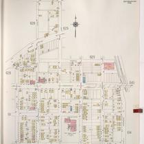
A portion of Kansas City from Thompson Avenue south to Independence Avenue and from Elmwood Avenue east to Van Brunt Boulevard, showing buildings and streets. Large numbers at edges of page refer to page with adjoining area. Indicated at top of sheet that this page number corresponds with pages 629 and 717 in Vol. 5, 1909-1938.
-
Date
-
1940/1941
-
Object Type
-
Map
-
-
Title
-
Sanborn Map, Kansas City, Vol. 5, 1940-1941, Page p1214
-
Description
-
A portion of Kansas City from E. 15th Street south to E. 18th Street and from Crystal Avenue east to Winchester Avenue, showing buildings and streets. Large numbers at edges of page refer to page with adjoining area. Indicated at top of sheet that this page number corresponds with pages 698 and 700-702 in Vol. 5, 1909-1938.
-
Date
-
1940/1941
-
Object Type
-
Map
-
-
Title
-
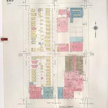
Sanborn Map, Kansas City, Vol. 3, 1909-1957, Page p309
-
Description
-
A portion of Kansas City from Truman Road south to E. 17th Street and from Olive east to Montgall Avenue, showing buildings, streets, and additions. Large numbers at edges of page refer to page with adjoining area.
-
Date
-
1909/1957
-
Object Type
-
Map
-
-
Title
-
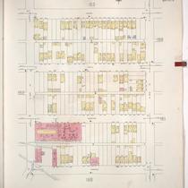
Sanborn Map, Kansas City, Vol. 3, 1909-1957, Page p347
-
Description
-
A portion of Kansas City from E. 21st Street south to E. 23rd Street and from Campbell Street east to Troost Avenue, showing buildings, streets, and additions. Large numbers at edges of page refer to page with adjoining area.
-
Date
-
1909/1957
-
Object Type
-
Map
-
-
Title
-
Sanborn Map, Kansas City, Vol. 3, 1909-1950, Page p309
-
Description
-
A portion of Kansas City from Truman Road south to E. 17th Street and from Olive east to Montgall Avenue, showing buildings, streets, and additions. Large numbers at edges of page refer to page with adjoining area.
-
Date
-
1909/1950
-
Object Type
-
Map
Pages
