-
-
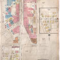
Title
-
Sanborn Map, Kansas City, Vol. 4, 1909-1950, Page p526
-
Description
-
A portion of Kansas City from E. 39th Street south to E. 40th Street and from Baltimore Avenue east to Walnut Street, showing buildings, streets, and additions. Large numbers at edges of page refer to page with adjoining area.
-
Date
-
1909/1950
-
Object Type
-
Map
-

-
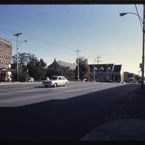
Title
-
Montrose Apartments
-
Description
-
Photograph of the Montrose Apartments building at the corner of Walnut, 40th, and Main Streets in the early 1980s. The building was designed by Shepard & Wiser and built in 1923. It was demolished in early 1998 and the site used for a parking lot. The Old Westport Cashsaver grocery store can be seen to the north of the building.
-
Date
-
1980~/1989~
-
Object Type
-
Photograph
-
-
Title
-
Westport and Main
-
Description
-
Photograph of the Montrose Apartments building at the corner of 40th and Main Streets in the early 1980s, looking east from the intersection of Westport Road and Main. The building was designed by Shepard & Wiser and built in 1923. It was demolished in early 1998 and the site used for a parking lot. St. Paul's Episcopal Church stands to the south, across 40th Street.
-
Date
-
1980~/1989~
-
Object Type
-
Photograph
-

-
Title
-
3951-79 Main Street
-
Description
-
Photographs of stores and an apartment building on the 3900 block of Main Street in the early 1980s. The Old Westport Cash Saver grocery store, at 3967 Main, and the Montrose Apartment building, at the corner of 40th, Walnut, and Main Streets, are among the buildings pictured. The Montrose Apartments were demolished in early 1998 and the site was used for a parking lot.
-
Date
-
1980~/1989~
-
Object Type
-
Photograph
