-

-
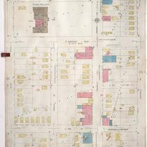
Title
-
Sanborn Map, Kansas City, Vol. 3, 1909-1957, Page p318
-
Description
-
A portion of Kansas City from E. 17th Street south to E. 19th Street and from Tracy Avenue east to The Paseo, showing buildings, streets, and additions. Large numbers at edges of page refer to page with adjoining area.
-
Date
-
1909/1957
-
Object Type
-
Map
-

-
Title
-
Sanborn Map, Kansas City, Vol. 6, 1917-1957, Page p854
-
Description
-
A portion of the Intercity District between Kansas City, Missouri, and Independence, Missouri, from E. 11th Street south to E. 14th Street and from Glenwood Avenue east to Ralston Avenue, showing buildings, streets, and additions. Large numbers at edges of page refer to page with adjoining area. Noted at top of map, "Add'l Sheet, Nov. 1936. Independence."
-
Date
-
1917/1957
-
Object Type
-
Map
-

-
Title
-
Sanborn Map, Kansas City, Vol. 9, 1930-1941, Page p0921
-
Description
-
A portion of Kansas City from E. 56th Street south to E. 57th Street and from Rockhill Road east to Forest Avenue, showing buildings, streets, and additions. Large numbers at edges of page refer to page with adjoining area.
-
Date
-
1930/1941
-
Object Type
-
Map
-
-
Title
-
Sanborn Map, Kansas City, Vol. 9, 1930-1941, Page p1107
-
Description
-
A portion of Kansas City from E. 70th Street Terrace south to E. 72nd Street and from Olive Street east to Montgall Avenue, showing buildings, streets, and additions. Large numbers at edges of page refer to page with adjoining area.
-
Date
-
1930/1941
-
Object Type
-
Map
-
-
Title
-
Sanborn Map, Kansas City, Vol. 2, 1940-1950, Page p248
-
Description
-
A portion of northeast Kansas City from Independence Boulevard south to E. 8th Street and from Prospect Avenue east to Chestnut Avenue, showing buildings and streets. Large numbers at edges of pages refer to page with adjoining area.
-
Date
-
1940/1950
-
Object Type
-
Map
-

-
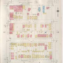
Title
-
Sanborn Map, Kansas City, Vol. 3, 1909-1957, Page p319
-
Description
-
A portion of Kansas City from E. 17th Street Terrace south to E. 19th Street and from The Paseo east to Woodland Avenue, showing buildings, streets, and additions. Large numbers at edges of page refer to page with adjoining area.
-
Date
-
1909/1957
-
Object Type
-
Map
-
-
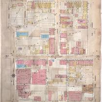
Title
-
Sanborn Map, Kansas City, Vol. 3, 1909-1950, Page p318
-
Description
-
A portion of Kansas City from E. 17th Street south to E. 19th Street and from Tracy Avenue east to The Paseo, showing buildings, streets, and additions. Large numbers at edges of page refer to page with adjoining area. Handwritten at the top of the page, "Negro Section."
-
Date
-
1909/1950
-
Object Type
-
Map
-

-
Title
-
Sanborn Map, Kansas City, Vol. 3, 1909-1950, Page p388
-
Description
-
A portion of Kansas City from E. 26th Street Terrace south to Lockridge and from Agnes Avenue east to Indiana Avenue, showing buildings, streets and additions. Large numbers at edges of page refer to page with adjoining area.
-
Date
-
1909/1950
-
Object Type
-
Map
-

-
Title
-
Sanborn Map, Kansas City, Vol. 6, 1917-1945, Page p767
-
Description
-
A portion of northeastern Kansas City from E. 39th Street south to about E. 41st Street and from Wabash Avenue east to Chestnut Avenue, showing buildings, streets, and additions. Large numbers at edges of page refer to page with adjoining area.
-
Date
-
1917/1945
-
Object Type
-
Map
-

-
Title
-
Sanborn Map, Kansas City, Vol. 6, 1917-1945, Page p757
-
Description
-
A portion of northeastern Kansas City from E. 31st Street south to E. 33rd Street and from Walrond Avenue east to Indiana Avenue, showing buildings, streets, and additions. Large numbers at edges of page refer to pages with adjoining area.
-
Date
-
1917/1945
-
Object Type
-
Map
