-

-
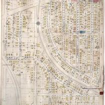
Title
-
Sanborn Map, Kansas City, Vol. 6, 1917-1945, Page p760
-
Description
-
A portion of northeastern Kansas City from E. 35th Street south to E. 36th Street and from Bellefontaine Avenue east to Indiana Avenue, showing buildings, streets, and additions. Large numbers at edges of page refer to page with adjoining area.
-
Date
-
1917/1945
-
Object Type
-
Map
-
-
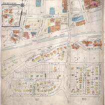
Title
-
Sanborn Map, Kansas City, Vol. 6, 1917-1945, Page p840
-
Description
-
A portion of the Intercity District connecting Kansas City, Missouri, and Independence, Missouri, from Independence Avenue south to E. 11th Street and from Overton Avenue east to Hardy Avenue, showing buildings, streets, and additions. Large numbers at edges of page refer to page with adjoining area.
-
Date
-
1917/1945
-
Object Type
-
Map
-

-
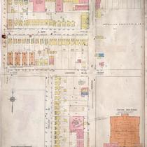
Title
-
Sanborn Map, Kansas City, Vol. 6, 1917-1945, Page p783
-
Description
-
A portion of northeastern Kansas City from E. 49th Street south to E. 51st Street and from Prospect Avenue east to South Benton Boulevard, showing buildings, streets, and additions. Large numbers at edges of page refer to page with adjoining area.
-
Date
-
1917/1945
-
Object Type
-
Map
-

-
Title
-
Sanborn Map, Kansas City, Vol. 6, 1917-1945, Page p831
-
Description
-
A portion of Kansas City from E. 80th Street south to E. 81st Street Terrace and from Highland Avenue east to Euclid Avenue, showing buildings, streets, and additions. Large numbers at edges of page refer to page with adjoining area.
-
Date
-
1917/1945
-
Object Type
-
Map
-

-
Title
-
Sanborn Map, Kansas City, Vol. 6, 1917-1945, Page p767
-
Description
-
A portion of northeastern Kansas City from E. 39th Street south to about E. 41st Street and from Wabash Avenue east to Chestnut Avenue, showing buildings, streets, and additions. Large numbers at edges of page refer to page with adjoining area.
-
Date
-
1917/1945
-
Object Type
-
Map
-
-
Title
-
Sanborn Map, Kansas City, Vol. 6, 1917-1945, Page p797
-
Description
-
A portion of western Kansas City from W. 47th Street south to W. 50th Street and from Jefferson Avenue east to Wyandotte Avenue, showing buildings, streets, and additions. Large numbers at edges of page refer to page with adjoining area.
-
Date
-
1917/1945
-
Object Type
-
Map
-
-
Title
-
Sanborn Map, Kansas City, Vol. 6, 1917-1945, Page p757
-
Description
-
A portion of northeastern Kansas City from E. 31st Street south to E. 33rd Street and from Walrond Avenue east to Indiana Avenue, showing buildings, streets, and additions. Large numbers at edges of page refer to pages with adjoining area.
-
Date
-
1917/1945
-
Object Type
-
Map
