Pages
-

-
Title
-
O. K. Creek
-
Date
-
1909-03-10
-
Object Type
-
Newspaper Article
-

-
Title
-
Cox's Pasture
-
Description
-
Reminiscences about the land where the post office building is on Pershing Road in 1907, known then as "Cox's pasture."
-
Date
-
1949-12-25
-
Object Type
-
Newspaper Article
-

-
Title
-
OK Creek and Building
-
Description
-
OK Creek and unidentified building at 21st and Wyandotte streets, future sight of Union Station.
-
Date
-
1885
-
Object Type
-
Photograph
-

-
Title
-
Main Street Sewer
-
Description
-
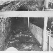
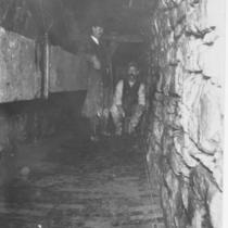
Underground construction view of Main Street Sewer at O.K. Creek.
-
Object Type
-
Photograph
-

-
Title
-
Main Street Sewer
-
Description
-
Underground construction view of Main Street Sewer at O.K. Creek.
-
Object Type
-
Photograph
-

-
Title
-
Main Street Sewer
-
Description
-
Above-ground construction view of Main Street Sewer at O.K. Creek.
-
Object Type
-
Photograph
-

-
Title
-
Main Street Sewer
-
Description
-
Underground construction view of Main Street Sewer at O.K. Creek.
-
Object Type
-
Photograph
-
-
Title
-
Main Street Sewer
-
Description
-
Underground construction view of Main Street Sewer at O.K. Creek.
-
Object Type
-
Photograph
-
-
Title
-
Main Street Sewer
-
Description
-
Underground construction view of Main Street Sewer at O.K. Creek
-
Object Type
-
Photograph
-

-
Title
-
OK Creek
-
Description
-
Creek and unidentified building at 21st and Wyandotte streets, future sight of Union Station.
-
Date
-
1889
-
Object Type
-
Photograph
-

-
Title
-
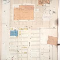
Sanborn Map, Kansas City, Vol. 1, 1909-1938, Page p082
-
Description
-
A portion of Kansas City from about W. 24th Street south to W. 25th Street and from Jefferson Street east to Broadway, showing buildings, streets, railroads, and additions. Large numbers at edges of page refer to page with adjoining area.
-
Date
-
1909/1938
-
Object Type
-
Map
-

-
Title
-
Sanborn Map, Kansas City, Vol. 1, 1909-1938, Page p081
-
Description
-
A portion of Kansas City from W. 25th Street south to W. 26th Street and from Madison Avenue east to Jefferson Street, showing buildings, streets, and additions. Large numbers at edges of page refer to page with adjoining area.
-
Date
-
1909/1938
-
Object Type
-
Map
-
-
Title
-
Sanborn Map, Kansas City, Vol. 1, 1909-1938, Page p084
-
Description
-
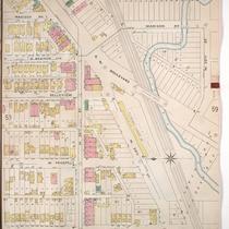
A portion of Kansas City from Pershing Road south to W. 26th Street and from Broadway east to Wyandotte, showing buildings, streets, and additions. Large numbers at edges of page refer to page with adjoining area.
-
Date
-
1909/1938
-
Object Type
-
Map
-

-
Title
-
Sanborn Map, Kansas City, Vol. 1, 1909-1938, Page p077
-
Description
-
A portion of Kansas City from W. 22nd Street south to Pershing Road and from Broadway east to Wyandotte, showing buildings, streets, and additions. Large numbers at edges of page refer to page with adjoining area. Noted at top of sheet, "New Sheet April 1914 (formerly sheet 76)."
-
Date
-
1909/1938
-
Object Type
-
Map
-

-
Title
-
Sanborn Map, Kansas City, Vol. 1, 1909-1938, Page p083
-
Description
-
A portion of Kansas City from W. 25th Street south to W. 26th Street and from Jefferson east to Broadway, showing buildings, streets, and additions. Large numbers at edges of page refer to page with adjoining area.
-
Date
-
1909/1938
-
Object Type
-
Map
-

-
Title
-
Map Showing Sewer Districts and Sewers of Kansas City, Missouri
-
Description
-
Map of Kansas City, Missouri, bordered by the Kansas and Missouri Rivers on the west and north, and by Woodland Avenue and 24th Street on the east and south, respectively. Shows locations of pipe sewers, brick sewers, public sewers, O.K. Creek intercepting sewer, with sewer district numbers indicated.
-
Date
-
1885-01-01
-
Object Type
-
Map
-
-
Title
-
Sanborn Map, Kansas City, Vol. 1, 1895-1907, Page p054
-
Description
-
North central part of early Kansas City in the West Bottoms area from about W. 24th Street south to W. 25th Street and from Holly Street east to Madison Avenue, showing buildings, streets, and O. K. Creek. Large numbers at edges of page refer to page with adjoining area.
-
Date
-
1895/1907
-
Object Type
-
Map
-

-
Title
-
Sanborn Map, Kansas City, Vol. 3, 1896-1907, Page p259
-
Description
-
Southeastern part of early Kansas City from E. 18th Street south to E. 20th Street and from Tracy Avenue east to Vine Street, showing buildings, streets, railroad lines, and O.K. Creek. Large numbers at edges of page refer to page with adjoining area.
-
Date
-
1896/1907
-
Object Type
-
Map
-
-
Title
-
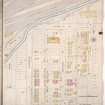
Sanborn Map, Kansas City, Vol. 1, 1895-1907, Page p050
-
Description
-
North central part of early Kansas City in Union Hill from O. K. Creek south to W. Esplanado Street and from Marsh Street east to Main Street, showing buildings, streets, and railroad lines. Large numbers at edges of page refer to page with adjoining area.
-
Date
-
1895/1907
-
Object Type
-
Map
Pages
