-
-
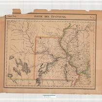
Title
-
Partie des Etats-Unis
-
Description
-
Early map of Missouri and Illinois, apparently from a French atlas. Much of what is now eastern Kansas is also included, along with small sections of Kentucky and Tennessee. An early organization of Missouri counties is in evidence, including Lillard County. Some early trails/exploration routes are indicated, as well as locations of mineral resources. Some Indian villages are indicated in the Kansas portion, with estimated populations. The etablissment de Chouteau on the Osage River is featured.
-
Date
-
1825
-
Object Type
-
Map
-

-
Title
-
P23 Native American/Western Photograph Collection Finding Aid
-
Description
-
This collection contains over over 140 glass plate negatives, cabinet cards, and assorted prints. The images are primarily of Native American peoples, cowboys, and "Boomer" settlers in Indian Territory (Oklahoma) during the late-1880s through the early-1900s. The principal tribes represented include the Ponca, Kiowa, Comanche, Sac and Fox, Otoe, Pawnee and Apache. Many of the images were taken by prominent western photographers of the period including Thomas Croft, William S. Prettyman, George Cornish, and William E. Irwin. There are also fifteen photographs of Sioux Indians and U.S. soldiers taken by the Northwestern Photo Company during the 1890/91 conflict at Wounded Knee Creek, South Dakota.
-
Date
-
1880~/1901~
-
Object Type
-
Finding Aid
