Pages
-

-
Title
-
Bell Telephone Administration Building
-
Description
-
Chapter about the original Telephone Building owned by Southwestern Bell Telephone Company on the northwest corner of 11th and Oak Streets. It was completed in 1919. Fourteen floors were added and completed the spring of 1929. Hoit, Price & Barnes, architects, designed a gothic exterior faced with terra cotta. The building has 28 stories with set backs at the 22nd and 25th floors.
-
Date
-
1934
-
Object Type
-
Book Section
-

-
Title
-
Southwestern Bell Regional Headquarters Building
-
Description
-
Partial view of the Southwestern Bell Regional Headquarters Building, located at 500 E. 8th Street. Kivett & Myers received an award for the design of this building.
-
Object Type
-
Photograph
-

-
Title
-
Sanborn Map, Kansas City, Vol. 5, 1909-1938, Page p642
-
Description
-
A portion of Kansas City from E. 11th Street south to E. 13th Street and from Cleveland Avenue east to Norton Avenue, showing buildings, streets, and additions. Large numbers at edges of page refer to page with adjoining area.
-
Date
-
1909/1938
-
Object Type
-
Map
-
-
Title
-
Sanborn Map, Kansas City, Vol. 4, 1909-1950, Page p527
-
Description
-
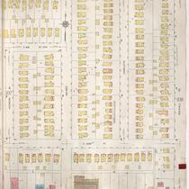
A portion of Kansas City from E. 39th Street south to E. 40th Street and from Walnut Street east to Locust Street, showing buildings, streets, and additions. Large numbers at edges of page refer to page with adjoining area.
-
Date
-
1909/1950
-
Object Type
-
Map
-

-
Title
-
Sanborn Map, Kansas City, Vol. 9, 1930-1957, Page p0938
-
Description
-
A portion of Kansas City from E. 61st Street south to E. 63rd Street and from Kenwood Avenue east to Rockhill Road, showing buildings, streets, and additions. Large numbers at edges of page refer to page with adjoining area.
-
Date
-
1930/1957
-
Object Type
-
Map
-
-
Title
-
Sanborn Map, Kansas City, Vol. 9, 1930-1941, Page p0938
-
Description
-
A portion of Kansas City from E. 61st Street south to E. 63rd Street and from Kenwood Avenue east to Rockhill Road, showing buildings, streets, and additions. Large numbers at edges of page refer to page with adjoining area.
-
Date
-
1930/1941
-
Object Type
-
Map
-
-
Title
-
Sanborn Map, Kansas City, Vol. 6, 1917-1957, Page p767
-
Description
-
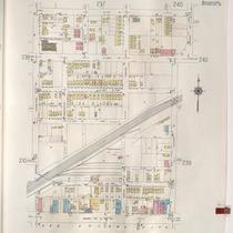
A portion of northeastern Kansas City from E. 39th Street south to about E. 41st Street and from Wabash Avenue east to Chestnut Avenue, showing buildings, streets, and additions. Large numbers at edges of page refer to page with adjoining area.
-
Date
-
1917/1957
-
Object Type
-
Map
-
-
Title
-
Sanborn Map, Kansas City, Vol. 2, 1940-1957, Page p238
-
Description
-
A portion of northeast Kansas City from E. 11th Street south to Truman Road and from Cleveland Avenue east to Spruce Avenue, showing buildings, streets, and railroad lines. Large numbers at edges of pages refer to page with adjoining area.
-
Date
-
1940/1957
-
Object Type
-
Map
-

-
Title
-
Sanborn Map, Kansas City, Vol. 2, 1940-1950, Page p238
-
Description
-
A portion of northeast Kansas City from E. 11th Street south to Truman Road and from Cleveland Avenue east to Spruce Avenue, showing buildings, streets, and railroad lines. Large numbers at edges of pages refer to page with adjoining area.
-
Date
-
1940/1950
-
Object Type
-
Map
-
-
Title
-
Sanborn Map, Kansas City, Vol. 3, 1909-1950, Page p342
-
Description
-
A portion of Kansas City from E. 23rd Street south to City View Avenue and from Main Street east to McGee, showing buildings, streets, and additions. Large numbers at edges of page refer to page with adjoining area.
-
Date
-
1909/1950
-
Object Type
-
Map
-
-
Title
-
Sanborn Map, Kansas City, Vol. 4, 1909-1950, Page p575
-
Description
-
A portion of Kansas City from W. 34th Street south to W. 36th Street and from Roanoke Road east to Terrace, showing buildings, streets, and additions. Large numbers at edges of page refer to page with adjoining area. At top of map, "Add'l Sheet, Nov. 1918."
-
Date
-
1909/1950
-
Object Type
-
Map
-

-
Title
-
Sanborn Map, Kansas City, Vol. 2, 1909-1937, Page p243
-
Description
-
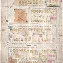
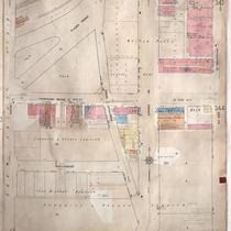
A portion of Kansas City from E. 13th Street south to E. 15th Street and from Oak Street east to Holmes Street, showing buildings, streets, and additions. Large numbers at edges of page refer to page with adjoining area.
-
Date
-
1909/1937
-
Object Type
-
Map
-
-
Title
-
Sanborn Map, Kansas City, Vol. 1, 1939-1958, Page p086
-
Description
-
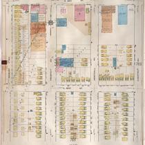
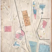
A portion of Kansas City from E. 14th Street south to Truman Road and from Oak Street east to Holmes, showing buildings and streets. Large numbers at edges of page refer to page with adjoining area.
-
Date
-
1939/1958
-
Object Type
-
Map
-
-
Title
-
Saint Patrick's Catholic Church
-
Description
-
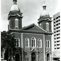
View looking northwest of Oratory of Old Saint Patrick Catholic Church Building at 806 Cherry Street. A truck for Gray's Welding and Boiler Repair is parked on Cherry Street. A sign for Southwestern Bell can be seen on the right hand side of the image.
-
Date
-
1985~
-
Object Type
-
Photograph
-

-
Title
-
SC103-1 1976 Republican National Convention Memorabilia Finding Aid
-
Description
-
This collection contains three buttons, one commemorative coin, and two brass cattle rings that were distributed during the Republican National Convention held at Kemper Arena August 16-19, 1976, in Kansas City, Missouri.
-
Date
-
1976
-
Object Type
-
Finding Aid
-
-
Title
-
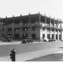
Southwestern Bell Telephone Company Storage Building
-
Description
-
Exterior, street level view of building taken during construction. Identified as the Southwestern Bell Telephone Company storage building located on E. 15th Street in Kansas City, Missouri.
-
Date
-
1930~
-
Object Type
-
Photograph
-
-
Title
-
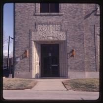
1123 Cleveland Avenue
-
Description
-
Photograph of a door on the west side of the Southwestern Bell facility at the southwest corner of 12th Street and Cleveland Avenue in the early 1980s. The building, built in 1930, housed the Benton and and Chestnut exchanges.
-
Date
-
1980~/1989~
-
Object Type
-
Photograph
Pages
