Pages
-

-
Title
-
Pipe Bridge over Turkey Creek
-
Description
-
Photograph showing a pipe bridge across Turkey Creek in front of the Imperial Brewery on Southwest Blvd., between 28th and 29th streets.
-
Date
-
1910-10-27
-
Object Type
-
Photograph
-
-
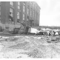
Title
-
Turkey Creek Pumping Station
-
Description
-
View of debris from the 1951 Flood outside the Turkey Creek Pumping Station.
-
Date
-
1951
-
Object Type
-
Photograph
-

-
Title
-
McDowell Mill
-
Date
-
1911-11-12
-
Object Type
-
Newspaper Article
-

-
Title
-
West Bottoms
-
Description
-
Turkey Creek, near 23rd Street.
-
Date
-
1895
-
Object Type
-
Photograph
-

-
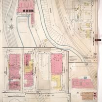
Title
-
Sanborn Map, Kansas City, Vol. 1, 1909-1938, Page p095
-
Description
-
A portion of Kansas City from E. 30th Street south to E. 31st Street and from Southwest Boulevard east to Wyoming, showing buildings, streets, and additions. Large numbers at edges of page refer to page with adjoining area.
-
Date
-
1909/1938
-
Object Type
-
Map
-
-
Title
-
Sanborn Map, Kansas City, Vol. 1, 1909-1938, Page p066
-
Description
-
A portion of Kansas City from 23rd Street Trafficway south to W. 24th Street and from Brook east to Fairmount Avenue, showing buildings, railroads, streets, and additions. Large numbers at edges of page refer to page with adjoining area.
-
Date
-
1909/1938
-
Object Type
-
Map
-
-
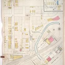
Title
-
Sanborn Map, Kansas City, Vol. 1, 1909-1938, Page p091
-
Description
-
A portion of Kansas City from W. 27th Street south to E. 30th Street and from Bell east to Southwest Boulevard, showing buildings, streets, and additions. Large numbers at edges of page refer to page with adjoining area.
-
Date
-
1909/1938
-
Object Type
-
Map
-

-
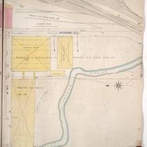
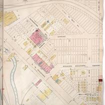
Title
-
Sanborn Map, Kansas City, Vol. 1, 1909-1938, Page p092
-
Description
-
A portion of Kansas City from W. 28th Street south to W. 29th Street and from Garfield Court east to Terrace, showing buildings, streets, and additions. Large numbers at edges of page refer to page with adjoining area.
-
Date
-
1909/1938
-
Object Type
-
Map
-

-
Title
-
Jasper-Newton Counties
-
Description
-
Geological map showing mining and mineralized areas of Jasper and Netwon counties depicting bedrock and mineralized areas, including current and prospective mining sites. Also included are local schools, churches, railroads, cemeteries, various localities, and Turkey Creek.
-
Date
-
1920
-
Object Type
-
Map
-
-
Title
-
Sanborn Map, Kansas City, Vol. 1, 1895-1907, Page p038
-
Description
-
North central part of early Kansas City from W. 19th Street south a few blocks and from the state line east to Wyoming Street, showing the Kansas City Stock Yards Company sheep sheds. Large numbers at edges of page refer to page with adjoining area.
-
Date
-
1895/1907
-
Object Type
-
Map
-
-
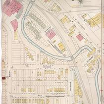
Title
-
Sanborn Map, Kansas City, Vol. 1, 1895-1907, Page p078
-
Description
-
South central part of early Kansas City in the West Side area from Turkey Creek south to W. 31st Street and from the state line east to just east of Genesse Street, showing buildings, streets, and Turkey Creek. Large numbers at edges of page refer to page with adjoining area.
-
Date
-
1895/1907
-
Object Type
-
Map
-

-
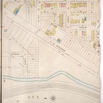
Title
-
Sanborn Map, Kansas City, Vol. 1, 1895-1907, Page p075
-
Description
-
Central part of early Kansas City in the West Side area from W. 28th Street south to W. 29th Street and from Southwest Boulevard east to Holly Street, showing buildings, streets, and additions.
-
Date
-
1895/1907
-
Object Type
-
Map
-
-
Title
-
Sanborn Map, Kansas City, Vol. 1, 1895-1907, Page p058
-
Description
-
Central part of early Kansas City from about W. 26th Street south to W. 28th Street and from Turkey Creek east to Holly Street, showing buildings, streets, and railroad lines. Large numbers at edges of page refer to page with adjoining area.
-
Date
-
1895/1907
-
Object Type
-
Map
-
-
Title
-
Sanborn Map, Kansas City, Vol. 1, 1895-1907, Page p077
-
Description
-
South central part of early Kansas City in the West Bottoms from Blaine Street south to Southwest Boulevard and from Bell Street east to about Fairmount Avenue, showing buildings, streets, and Turkey Creek. Large numbers at edges of page refer to page with adjoining area.
-
Date
-
1895/1907
-
Object Type
-
Map
-

-
Title
-
Sanborn Map, Kansas City, Vol. 1, 1895-1907, Page p059
-
Description
-
Central part of early Kansas City from W. 25th Street south to W. 26th Street and from Holly Street east to Madision Avenue, showing buildings, streets, and Turkey Creek. Large numbers on edges of page refer to page with adjoining area.
-
Date
-
1895/1907
-
Object Type
-
Map
-

-
Title
-
Turkey Creek Flood Scene
-
Description
-
Photograph of Turkey Creek in the West Bottoms. Debris from an unknown flood can be seen . The American Royal Exposition Building and sheep barn can be seen in the background. The image was taken from an area west of Brook Street at about 23rd street and faces northwest.
-
Date
-
1910~
-
Object Type
-
Photograph
-

-
Title
-
Geologic Cross Sections of Kansas City and Jackson County
-
Description
-
Six cross sections of areas of Jackson County, Missouri, and Kansas City, Missouri, illustrate altitude above sea level and types of bedrock. Labels display locations of creeks and rivers, as well as major city thoroughfares including Southwest Boulevard, Armour Boulevard, and 75th Street.
-
Object Type
-
Map
-

-
Title
-
Jasper County
-
Description
-
Geological map shows mining and mineralized areas of Jasper County, Missouri, and some adjacent areas. Legend indicates bedrock, mines, and mineralized areas, as well as topographical contours, geological features, and local towns, water formations, railroads, roads, and buildings.
-
Date
-
1919
-
Object Type
-
Map
Pages
