Pages
-

-
Title
-
Union Pacific Railroad
-
Description
-
Photos, map, and information on the Union Pacific Railroad from Kansas City to beyond the Rocky Mountains.
-
Object Type
-
Vertical File
-

-
Title
-
Railroad Can Demolish Bridge, Judge Rules
-
Description
-
Cole County Senior Judge Byron Kinder ruled that Union Pacific Railroad can demolish the railroad bridge at Boonville. The city of Boonville had wanted to incorporate the old bridge with the Katy Trail.
-
Date
-
2006-04-25
-
Object Type
-
Newspaper Article
-

-
Title
-
Threat to Bridge Spurs Fears
-
Description
-
Discussion about the plans of Union Pacific Railroad, current owner of the old metal railroad bridge at Boonville, to tear down the bridge. Katy Trail enthusaists hope the bridge can be used as a river crossing.
-
Date
-
2005-07-03
-
Object Type
-
Newspaper Article
-
-
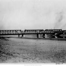
Title
-
Railway Bridge
-
Description
-
Distant view from eastern shore of the Kansas River of entire bridge.
-
Object Type
-
Photograph
-

-
Title
-
Missouri Pacific Railroad Bridge during 1903 Flood
-
Description
-
The Missouri Pacific Railroad Bridge over the Kansas River during the 1903 flood. The people in the image are standing at the footing of the Union Pacific Railroad Bridge, which was washed away during the flood.
-
Date
-
1903
-
Object Type
-
Photograph
-

-
Title
-
Sanborn Map, Kansas City, Vol. 1, 1909-1938, Page p028
-
Description
-
A portion of Kansas City from W. 9th Street south to W. 11th Street and from Mulberry east to Santa Fe, showing buildings, streets, railroads, and additions. Large numbers at edges of page refer to page with adjoining area.
-
Date
-
1909/1938
-
Object Type
-
Map
-

-
Title
-
Sanborn Map, Kansas City, Vol. 1A, 1939-1949, Page p182
-
Description
-
A portion of Kansas City from St. Louis Avenue south to W. 12th Street and from the state line east to Liberty, showing buildings, railroads and streets. Large numbers at edges of page refer to page with adjoining area.
-
Date
-
1939/1949
-
Object Type
-
Map
-
-
Title
-
Sanborn Map, Kansas City, Vol. 1A, 1939-1949, Page p179
-
Description
-
A portion of Kansas City from Union Avenue south to W. 12th Street and from Liberty east to Mulberry, showing buildings, railroads and streets. Large numbers at edges of page refer to page with adjoining area.
-
Date
-
1939/1949
-
Object Type
-
Map
-

-
Title
-
Sanborn Map, Kansas City, Vol. 1A, 1939-1949, Page p188
-
Description
-
A portion of Kansas City from W. 9th Street south to W. 12th Street and from Santa Fe east to Jefferson, showing buildings, railroads and streets. Large numbers at edges of page refer to page with adjoining area.
-
Date
-
1939/1949
-
Object Type
-
Map
-

-
Title
-
Sanborn Map, Kansas City, Vol. 1A, 1939-1949, Page p180
-
Description
-
A portion of Kansas City from Union Avenue south to W. 12th Street and from Mulberry east to Santa Fe, showing buildings, railroads and streets. Large numbers at edges of page refer to page with adjoining area.
-
Date
-
1939/1949
-
Object Type
-
Map
-
-
Title
-
Sanborn Map, Kansas City, Vol. 1, 1909-1938, Page p026
-
Description
-
A portion of Kansas City from W. 9th Street south to W. 11th Street and from Wyoming east to Hickory, showing buildings, streets, railroads, and additions. Large numbers at edges of page refer to page with adjoining area.
-
Date
-
1909/1938
-
Object Type
-
Map
-
-
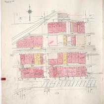
Title
-
Sanborn Map, Kansas City, Vol. 1, 1895-1907, Page p020
-
Description
-
Northwestern part of early Kansas City in West Bottoms from Union Avenue south to W. 12th Street and from Mulberry Street east to Santa Fe Street, showing buildings, streets, and railroad lines. Large numbers at edges of page refer to page with adjoining area.
-
Date
-
1895/1907
-
Object Type
-
Map
-
-
Title
-
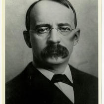
Edward Harriman
-
Description
-
Portrait of Edward Harriman, director of the Union Pacific Railroad.
-
Date
-
1900~
-
Object Type
-
Photograph
-
-
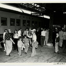
Title
-
Union Station Passengers
-
Description
-
View of passengers outside of a Union Pacific train.
-
Date
-
1967~
-
Object Type
-
Photograph
-

-
Title
-
Sanborn Map, Kansas City, Vol. 1, 1895-1907, Page p011
-
Description
-
Northern edge of early Kansas City. Quality Hill area showing buildings, railroad lines, and streets. Large numbers at edges of page refer to page showing adjoining area.
-
Date
-
1895/1907
-
Object Type
-
Map
-

-
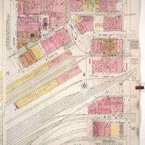
Title
-
Sanborn Map, Kansas City, Vol. 1, 1895-1907, Page p023
-
Description
-
Northwestern part of early Kansas City in the West Bottoms from the state line east to Wyoming Street showing buildings, streets, and the Kansas City Stockyards. Large numbers at edges of page refer to page with adjoining area.
-
Date
-
1895/1907
-
Object Type
-
Map
-

-
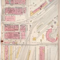
Title
-
Sanborn Map, Kansas City, Vol. 1, 1895-1907, Page p017
-
Description
-
Northwestern edge of early Kansas City in the West Bottoms district from just north of St. Louis Avenue south to W. 12th Street and from the state line east to Wyoming Street, showing buildings, streets, and railroad lines. Large numbers on edges of page refer to page showing adjoining area.
-
Date
-
1895/1907
-
Object Type
-
Map
-

-
Title
-
Sanborn Map, Kansas City, Vol. 1, 1895-1907, Page p018
-
Description
-
Northwestern part of early Kansas City from Missouri River south to St. Louis Avenue and from Santa Fe Street east to Bluff Street, showing buildings, streets, and railroad lines. Large numbers on edges of page refer to page with adjoining area.
-
Date
-
1895/1907
-
Object Type
-
Map
Pages

