-
-
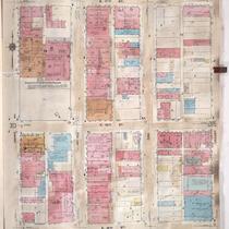
Title
-
Sanborn Map, Kansas City, Vol. 3, 1909-1957, Page p314
-
Description
-
A portion of Kansas City from E. 17th Street south to E. 19th Street and from Grand Avenue east to Locust, showing buildings, streets, and additions. Large numbers at edges of page refer to page with adjoining area.
-
Date
-
1909/1957
-
Object Type
-
Map
-
-
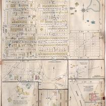
Title
-
Sanborn Map, Kansas City, Vol. 6, 1917-1957, Page p792
-
Description
-
A portion of eastern Kansas City from E. 67th Street south to E. 69th Street and from Myrtle Avenue east to Elmwood Avenue, showing buildings, streets, and additions. Separate sections show Hillcrest Country Club, George H. Nettleton Home for Aged Ladies, Park Gate, Associated Lumber and Millwork Company, and Blue Ridge Park. Large numbers at edges of page refer to page with adjoining area.
-
Date
-
1917/1957
-
Object Type
-
Map
-

-
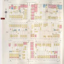
Title
-
Sanborn Map, Kansas City, Vol. 3, 1909-1957, Page p373
-
Description
-
A portion of Kansas City from E. 25th Street south to E. 26th Street and from Campbell Street east to Forest Avenue, showing buildings, streets, and additions. Large numbers at edges of page refer to page with adjoining area.
-
Date
-
1909/1957
-
Object Type
-
Map
-
-
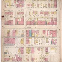
Title
-
Sanborn Map, Kansas City, Vol. 2, 1940-1957, Page p251
-
Description
-
A portion of northeast Kansas City from Independence Avenue south to E. 8th Street and from Indiana Avenue east to Bales Avenue, showing buildings and streets. Large numbers at edges of pages refer to page with adjoining area.
-
Date
-
1940/1957
-
Object Type
-
Map
-
-
Title
-
Sanborn Map, Kansas City, Vol. 2, 1896-1907, Page p118
-
Description
-
Northern part of early Kansas City from E. 16th Street south to E. 18th Street and from Main Street east to McGee Street, showing buildings, streets, and additions. Large numbers at edges of page refer to page with adjoining area.
-
Date
-
1896/1907
-
Object Type
-
Map
