-
-
Title
-
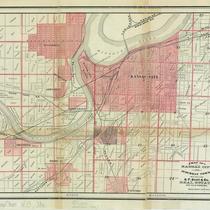
Map of Kansas City and Suburban Towns
-
Description
-
Two-color cadastral map shows political divisions including Kansas City, Missouri; Kansas City, Kansas; Westport, Missouri; and Wyandotte, Kansas; also shows roads, property owners, railroad lines, and some businesses. Under title: "S. F. Scott & Co. Real Estate and Loan Brokers."
-
Date
-
1881
-
Object Type
-
Map
-
-
Title
-
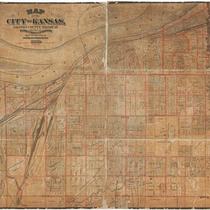
Map of the City of Kansas - Jackson County, Missouri
-
Description
-
Map of the City of Kansas, later known as Kansas City, in Jackson County, Missouri. Major streets, railroad lines, additions and subdivisions are marked. Landmarks and significant buildings are labeled. Harlem on the north side of the Missouri River in Clay County, Missouri, is shown.
-
Date
-
1880
-
Object Type
-
Map