Pages
-
-
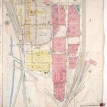
Title
-
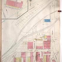
Sanborn Map, Kansas City, Vol. 1, 1909-1938, Page p046
-
Description
-
A portion of Kansas City from W. 17th Street south to W. 19th Street and from the State Line east to Liberty Street, showing buildings, streets, railroads, and additions. Large numbers at edges of page refer to page with adjoining area.
-
Date
-
1909/1938
-
Object Type
-
Map
-
-
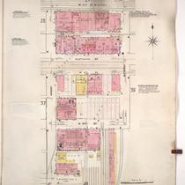
Title
-
Sanborn Map, Kansas City, Vol. 1, 1909-1938, Page p038
-
Description
-
A portion of Kansas City from W. 11th Street south to W. 13th Street Terrace and from Hickory east to Mulberry, showing buildings, streets, railroads, and additions. Large numbers at edges of page refer to page with adjoining area.
-
Date
-
1909/1938
-
Object Type
-
Map
-

-
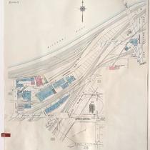
Title
-
Sanborn Map, Kansas City, Vol. 1A, 1939-1949, Page p189
-
Description
-
A portion of Kansas City from Woodswether Road south to W. 7th Street and from Madison Avenue east to Broadway, showing buildings, railroads and streets. Large numbers at edges of page refer to page with adjoining area
-
Date
-
1939/1949
-
Object Type
-
Map
-
-
Title
-
Sanborn Map, Kansas City, Vol. 1, 1909-1938, Page p039
-
Description
-
A portion of Kansas City from W. 11th Street south to W. 13th Street Terrace and from Mulberry east to Franklin Street, showing buildings, streets, railroads, and additions. Large numbers at edges of page refer to page with adjoining area.
-
Date
-
1909/1938
-
Object Type
-
Map
-
-
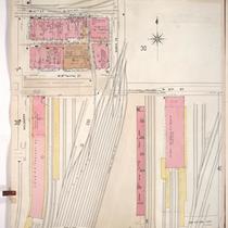
Title
-
Sanborn Map, Kansas City, Vol. 1, 1909-1938, Page p030
-
Description
-
A portion of Kansas City from Union Avenue south to W. 12th Street and from Santa Fe east to Lincoln, showing buildings, streets, railroads, and additions. Large numbers at edges of page refer to page with adjoining area.
-
Date
-
1909/1938
-
Object Type
-
Map
-

-
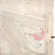
Title
-
Sanborn Map, Kansas City, Vol. 1A, 1939-1949, Page p188
-
Description
-
A portion of Kansas City from W. 9th Street south to W. 12th Street and from Santa Fe east to Jefferson, showing buildings, railroads and streets. Large numbers at edges of page refer to page with adjoining area.
-
Date
-
1939/1949
-
Object Type
-
Map
-

-
Title
-
Sanborn Map, Kansas City, Vol. 1A, 1939-1949, Page p101
-
Description
-
A portion of Kansas City from W. 3rd Street south to W. 5th Street and from Bluff Street east to Broadway, showing buildings, streets, and railroad lines. Large numbers at edges of page refer to page with adjoining area.
-
Date
-
1939/1949
-
Object Type
-
Map
-

-
Title
-
Sanborn Map, Kansas City, Vol. 1A, 1939-1949, Page p168
-
Description
-
A portion of Kansas City from W. 21st Street south to W. 25th Street and from State Line east to Terrace Street, showing buildings, railroads, and streets. Large numbers at edges of page refer to page with adjoining area.
-
Date
-
1939/1949
-
Object Type
-
Map
-

-
Title
-
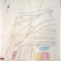
Sanborn Map, Kansas City, Vol. 1A, 1939-1949, Page p181
-
Description
-
A portion of Kansas City from W. 12th Street south to W. 16th Street and from Liberty east to Beardsley Road, showing buildings, railroads and streets. Large numbers at edges of page refer to page with adjoining area.
-
Date
-
1939/1949
-
Object Type
-
Map
-

-
Title
-
Sanborn Map, Kansas City, Vol. 1, 1909-1938, Page p001
-
Description
-
A portion of Kansas City from W. 5th Street south to W. 7th Street and from Woodswether Road east to Pennsylvania Avenue, showing buildings, streets, and railroads. Large numbers at edges of page refer to page with adjoining area.
-
Date
-
1909/1938
-
Object Type
-
Map
-

-
Title
-
Sanborn Map, Kansas City, Vol. 1, 1909-1938, Page p048
-
Description
-
A portion of Kansas City from W. 13th Street Terrace south to about W. 15th Street and from Hickory east to about Santa Fe, showing buildings, streets, and railroads. Large numbers at edges of page refer to page with adjoining area.
-
Date
-
1909/1938
-
Object Type
-
Map
-
-
Title
-
Sanborn Map, Kansas City, Vol. 1, 1909-1938, Page p002
-
Description
-
A portion of Kansas City from W. 3rd Street south to W. 5th Street and from Bluff Street east to Broadway, showing buildings, streets, railroads, and additions. Large numbers at edges of page refer to page with adjoining area.
-
Date
-
1909/1938
-
Object Type
-
Map
-
-
Title
-
Sanborn Map, Kansas City, Vol. 1, 1939-1958, Page p043
-
Description
-
A portion of Kansas City from W. 1st Street south to W. 3rd Street and from Broadway east to Wyandotte, showing buildings and streets. Large numbers at edges of page refer to page with adjoining area.
-
Date
-
1939/1958
-
Object Type
-
Map
-

-
Title
-
Sanborn Map, Kansas City, Vol. 1A, 1939-1949, Page p167
-
Description
-
A portion of Kansas City from W. 17th Street south to W. 21st Street and from Wyoming east to Holly Street, showing buildings, railroads, and streets. Large numbers at edges of page refer to page with adjoining area.
-
Date
-
1939/1949
-
Object Type
-
Map
-

-
Title
-
Sanborn Map, Kansas City, Vol. 1, 1909-1938, Page p003
-
Description
-
A portion of Kansas City from W. Front south to W. 3rd Street and from Broadway east to Wyandotte, showing buildings, streets, railroads, and additions. Large numbers at edges of page refer to page with adjoining area.
-
Date
-
1909/1938
-
Object Type
-
Map
-
-
Title
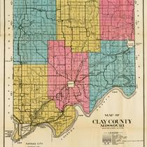
-
Map of Clay County Missouri
-
Description
-
Map of Clay County, Missouri, including railroads, electric lines, roads, schools, churches, and airports. Includes townships of Platte, Kearney, Washington, Gallatin, Liberty, and Fishing River. Includes cities of Liberty, Excelsior Springs, and North Kansas City. Also includes Kansas City Co. & St. Joe Electric Line.
-
Object Type
-
Map
-

-
Title
-
Sanborn Map, Kansas City, Vol. 1, 1895-1907, Page p055
-
Description
-
North central part of early Kansas City from W. 23rd Street south to W. 25th Street and from the Kanss City Water Works Reservoir east to Fairmount Avenue, showing buildings, streets, and railroad lines. Large numbers at edges of page refer to page with adjoining area.
-
Date
-
1895/1907
-
Object Type
-
Map
-
-
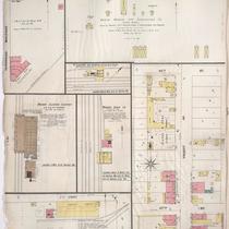
Title
-
Sanborn Map, Kansas City, Vol. 3, 1896-1907, Page p355u
-
Description
-
Northern and southern parts of early Kansas City in the industrial and railroad districts, showing buildings, railroad lines, streets, and additions. Large numbers at edges of page refer to page with adjoining area.
-
Date
-
1896/1907
-
Object Type
-
Map
-
-
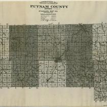
Title
-
Topographical Map of Putnam County
-
Description
-
Topographical map of Putnam County, Missouri, that includes main traveled roads, wagon roads, railroads, rivers, streams, schools, churches, and cemeteries. Includes the townships of York, Sherman, Union, Lincoln, Liberty, Grant, Medicine, Jackson, Wilson, Richland, and Elm.
-
Date
-
1910~
-
Object Type
-
Map
-
-
Title
-
Sanborn Map, Kansas City, Vol. 1A, 1939-1957, Page p189
-
Description
-
A portion of Kansas City from Woodswether Road south to W. 7th Street and from Madison Avenue east to Broadway, showing buildings, railroads, and streets. Large numbers at edges of page refer to page with adjoining area.
-
Date
-
1939/1957
-
Object Type
-
Map
Pages
