Pages
-

-
Title
-
Sanborn Map, Kansas City, Vol. 2, 1909-1937, Page p154
-
Description
-
A portion of Kansas City from Front Street south to E. 2nd Street and from Charlotte east to Harrison, showing buildings, streets, railroads, and additions. Large numbers at edges of page refer to page with adjoining area.
-
Date
-
1909/1937
-
Object Type
-
Map
-

-
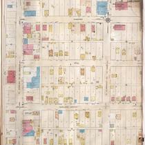
Title
-
Sanborn Map, Kansas City, Vol. 2, 1909-1937, Page p160
-
Description
-
A portion of Kansas City from E. 2nd Street south to E. 5th Street and from Holmes east to Harrison, showing buildings, streets, railroads, and additions. Large numbers at edges of page refer to page with adjoining area.
-
Date
-
1909/1937
-
Object Type
-
Map
-

-
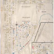
Title
-
Sanborn Map, Kansas City, Vol. 2, 1909-1937, Page p153
-
Description
-
A portion of Kansas City Old Town from E. 1st Street south to E. 2nd Street and from Cherry Street east to Charlotte, showing buildings, streets, railroads, and additions. Large numbers at edges of page refer to page with adjoining area.
-
Date
-
1909/1937
-
Object Type
-
Map
-

-
Title
-
Sanborn Map, Kansas City, Vol. 2, 1909-1937, Page p159
-
Description
-
A portion of Kansas City from E. 2nd Street south to E. 5th Street and from Oak Street east to Holmes, showing buildings, streets, railroads, and additions. Large numbers at edges of page refer to page with adjoining area.
-
Date
-
1909/1937
-
Object Type
-
Map
-

-
Title
-
Sanborn Map, Kansas City, Vol. 5, 1909-1938, Page p709
-
Description
-
A portion of Kansas City from E. 10th Street south to E. 12th Street and from Crystal Avenue east to Eastern Avenue, showing buildings, streets, railroads, and additions. Large numbers at edges of page refer to page with adjoining area. At the top of page, "Add'l Sheet, Aug. 1912."
-
Date
-
1909/1938
-
Object Type
-
Map
-

-
Title
-
Sanborn Map, Kansas City, Vol. 5, 1909-1938, Page p723
-
Description
-
A portion of Kansas City in the Sheffield Industrial District, showing buildings, railroads, and the Blue River. Large numbers at edges of page refer to page with adjoining area. At the top of page, "Add'l Sheet, Jan. 1919."
-
Date
-
1909/1938
-
Object Type
-
Map
-

-
Title
-
Sanborn Map, Kansas City, Vol. 5, 1909-1938, Page p703
-
Description
-
A portion of Kansas City in the Sheffield Industrial District showing Penrod Jurden and Clark Company and Black Sivalls and Bryson Metal Tank Manufacturers. Large numbers at edges of page refer to page with adjoining area.
-
Date
-
1909/1938
-
Object Type
-
Map
-

-
Title
-
Sanborn Map, Kansas City, Vol. 6, 1917-1957, Page p838
-
Description
-
A portion of the Intercity District connecting Kansas City, Missouri, and Independence, Missouri, from Morrell Avenue south to Independence Avenue and from Overton Avenue east to Hardy Avenue, showing buildings, streets, and additions. Large numbers at edges of page refer to page with adjoining area.
-
Date
-
1917/1957
-
Object Type
-
Map
-

-
Title
-
Sanborn Map, Kansas City, Vol. 6, 1917-1957, Page p837
-
Description
-
A portion of the Intercity District connecting Kansas City, Missouri, and Independence, Missouri, from Morrell Avenue south to Independence Avenue and from Brookside Drive east to Overton Avenue, showing buildings, streets, and additions. Large numbers at edges of page refer to page with adjoining area.
-
Date
-
1917/1957
-
Object Type
-
Map
-
-
Title
-
Sanborn Map, Kansas City, Vol. 6, 1917-1957, Page p857
-
Description
-
A portion of Sugar Creek, Missouri, from Ohio Street south to just past Independence Avenue and from S. Hardy Avenue east to Carlisle Street, showing buildings, streets, and additions. Large numbers at edges of page refer to page with adjoining area. Noted at top of map, "(708-Vol. 5) Add'l Sheet, Nov. 1939."
-
Date
-
1917/1957
-
Object Type
-
Map
-
-
Title
-
Sanborn Map, Kansas City, Vol. 6, 1917-1957, Page p844
-
Description
-
A portion of Sugar Creek from Chicago Street south to Burton and from N. Sterling Avenue east to N. Claremont Avenue, showing buildings, streets, and additions. Large numbers at edges of page refer to page with adjoining area.
-
Date
-
1917/1957
-
Object Type
-
Map
-

-
Title
-
Sanborn Map, Kansas City, Vol. 6, 1917-1957, Page p860
-
Description
-
A portion of Leeds, Missouri, from E. 37th Street south to E. 40th Street and from Bennington Avenue east to Raytown Road, showing buildings, streets, and additions. Large numbers at edges of page refer to page with adjoining area. Noted at top of map, "(705-706-707-724-Vol. 5) Add'l Sheet, Nov. 1939."
-
Date
-
1917/1957
-
Object Type
-
Map
-

-
Title
-
Sanborn Map, Kansas City, Vol. 6, 1917-1957, Page p859
-
Description
-
A portion of Leeds, Missouri, from E. 37th Street south to E. 40th Street and from Belmont Avenue east to Bennington Avenue, showing buildings, streets, and additions. Large numbers at edges of page refer to page with adjoining area. Noted at top of map, "(705-706-722-Vol. 5) Add'l Sheet, Nov. 1939."
-
Date
-
1917/1957
-
Object Type
-
Map
-

-
Title
-
Sanborn Map, Kansas City, Vol. 1A, 1939-1949, Page p184
-
Description
-
A portion of Kansas City from W. 8th Street south to W. 9th Street and from Liberty east to Mulberry, showing buildings, railroads and streets. Large numbers at edges of page refer to page with adjoining area.
-
Date
-
1939/1949
-
Object Type
-
Map
-

-
Title
-
Sanborn Map, Kansas City, Vol. 5, 1909-1938, Page p704
-
Description
-
A portion of Kansas City in the Blue Valley Industrial District and the Sheffield Industrial District showing Ralston Purina Company and Blue Valley Structural Steel Works. Large numbers at edges of page refer to page with adjoining area.
-
Date
-
1909/1938
-
Object Type
-
Map
-

-
Title
-
Sanborn Map, Kansas City, Vol. 5, 1909-1938, Page p701
-
Description
-
A portion of Kansas City from E. 13th Street south to E. 15th Street and from Eastern Avenue east to Manchester Avenue, showing buildings, streets, railroads, and additions. Large numbers at edges of page refer to page with adjoining area.
-
Date
-
1909/1938
-
Object Type
-
Map
-

-
Title
-
Sanborn Map, Kansas City, Vol. 1, 1909-1938, Page p006
-
Description
-
A portion of Kansas City from W. Front Street south to W. 3rd Street and from Delaware east to Main Street, showing buildings, streets, and additions. Large numbers at edges of page refer to page with adjoining area.
-
Date
-
1909/1938
-
Object Type
-
Map
-

-
Title
-
Sanborn Map, Kansas City, Vol. 1, 1909-1938, Page p005
-
Description
-
A portion of Kansas City from W. Front Street south to W. 3rd Street and from Wyandotte east to Delaware, showing buildings, streets, and additions. Large numbers at edges of page refer to page with adjoining area.
-
Date
-
1909/1938
-
Object Type
-
Map
-

-
Title
-
Sanborn Map, Kansas City, Vol. 5, 1909-1938, Page p722
-
Description
-
A portion of Kansas City in the Sheffield Industrial District, showing buildings, streets, and railroads. Large numbers at edges of page refer to page with adjoining area. At the top of page, "New Sheet, May 1922."
-
Date
-
1909/1938
-
Object Type
-
Map
Pages

