Pages
-

-
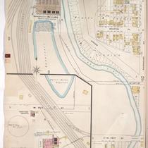
Title
-
Sanborn Map, Kansas City, Vol. 1, 1895-1907, Page p060
-
Description
-
Central part of early Kansas City from W. 27th Street south to W. 28th Street and from Holly Street east to Madison Avenue, showing buildings, streets, and schools. Large numbers at edges of page refer to page with adjoining area.
-
Date
-
1895/1907
-
Object Type
-
Map
-

-
Title
-
Sanborn Map, Kansas City, Vol. 1, 1895-1907, Page p054
-
Description
-
North central part of early Kansas City in the West Bottoms area from about W. 24th Street south to W. 25th Street and from Holly Street east to Madison Avenue, showing buildings, streets, and O. K. Creek. Large numbers at edges of page refer to page with adjoining area.
-
Date
-
1895/1907
-
Object Type
-
Map
-

-
Title
-
Sanborn Map, Kansas City, Vol. 1, 1895-1907, Page p020
-
Description
-
Northwestern part of early Kansas City in West Bottoms from Union Avenue south to W. 12th Street and from Mulberry Street east to Santa Fe Street, showing buildings, streets, and railroad lines. Large numbers at edges of page refer to page with adjoining area.
-
Date
-
1895/1907
-
Object Type
-
Map
-
-
Title
-
Sanborn Map, Kansas City, Vol. 1, 1895-1907, Page p055
-
Description
-
North central part of early Kansas City from W. 23rd Street south to W. 25th Street and from the Kanss City Water Works Reservoir east to Fairmount Avenue, showing buildings, streets, and railroad lines. Large numbers at edges of page refer to page with adjoining area.
-
Date
-
1895/1907
-
Object Type
-
Map
-

-
Title
-
Sanborn Map, Kansas City, Vol. 1, 1895-1907, Page p014
-
Description
-
Northwestern part of early Kansas City in the West Bottoms district from W. 8th Street south to St. Louis Avenue and from Hickory Street east to Santa Fe Street showing buildings, streets, and railroad lines. Large numbers at edges of page refer to page showing adjoining area.
-
Date
-
1895/1907
-
Object Type
-
Map
-

-
Title
-
Sanborn Map, Kansas City, Vol. 1, 1895-1907, Page p091
-
Description
-
Southern part of early Kansas City on the outskirts of Westport from about W. 40th Street south to about Archibald Street and from Briant Street east to Pennsylvania Avenue, showing buildings, streets, and additions. Large numbers at edges of page refer to page with adjoining area.
-
Date
-
1895/1907
-
Object Type
-
Map
-

-
Title
-
Sanborn Map, Kansas City, Vol. 1, 1895-1907, Page p063
-
Description
-
Central part of early Kansas City from about W. 24th Street south to W. 26th Street and from Washington Street east to Central Street, showing buildings, streets, and additions. Large numbers at edges of page refer to page with adjoining area.
-
Date
-
1895/1907
-
Object Type
-
Map
-

-
Title
-
Sanborn Map, Kansas City, Vol. 1, 1895-1907, Page p019s
-
Description
-
Skeleton map of northwestern part of early Kansas City in West Bottoms from Union Avenue south to W. 13th Street and from Wyoming Street east to Mulberry Street showing outlines of buildings at the time of publication. These sheets were used to record new developments in the area.
-
Date
-
1895/1907
-
Object Type
-
Map
-

-
Title
-
Sanborn Map, Kansas City, Vol. 1, 1895-1907, Page p027
-
Description
-
Northern part of early Kansas City from Aldine Place south to W. 15th Street and from Summit Street east to Washington Street. Large numbers at edges of page refer to page showing adjoining area.
-
Date
-
1895/1907
-
Object Type
-
Map
-

-
Title
-
Sanborn Map, Kansas City, Vol. 1, 1895-1907, Page p084
-
Description
-
Southern part of early Kansas City on the outskirts of Westport from W. 38th Street south to W. 40th Street and from Pennsylvania Avenue east to Central Street, showing buildings, streets, and additions. Large numbers at edges of page refer to page with adjoining area.
-
Date
-
1895/1907
-
Object Type
-
Map
-

-
Title
-
Sanborn Map, Kansas City, Vol. 1, 1895-1907, Page p031
-
Description
-
North central part of early Kansas City in the Crossroads Arts District from W. 15th Street south to W. 17th Street and from Summit Street east to Washington Street. Large numbers at edges of page refer to page with adjoining area.
-
Date
-
1895/1907
-
Object Type
-
Map
-

-
Title
-
Sanborn Map, Kansas City, Vol. 1, 1895-1907, Page p086
-
Description
-
Southern part of early Kansas City on the outskirts of Westport from Armour Boulevard south to E. 36th Street and from Walnut Street east to Oak Street, showing buildings and streets. Large numbers at edges of page refer to page with adjoining area.
-
Date
-
1895/1907
-
Object Type
-
Map
-

-
Title
-
Sanborn Map, Kansas City, Vol. 1, 1895-1907, Page p047
-
Description
-
North central part of early Kansas City in the Crossroads Arts District from W. 20th Street south to Milwaukee Avenue and from Washington Street east to Fort Scott Avenue, showing buildings, streets, and additions. Large numbers at edges of page refer to page with adjoining area.
-
Date
-
1895/1907
-
Object Type
-
Map
-

-
Title
-
Sanborn Map, Kansas City, Vol. 1, 1895-1907, Page p040
-
Description
-
North central part of early Kansas City in the West Bottoms from about W. 19th Street south to Cliff Street and from Allen Avenue east to Holly Street, showing buildings, streets, railroad lines, and shops. Large numbers at edges of page refer to page with adjoining area.
-
Date
-
1895/1907
-
Object Type
-
Map
-

-
Title
-
Sanborn Map, Kansas City, Vol. 1, 1895-1907, Page p033
-
Description
-
Northwestern part of early Kansas City from W. 15th Street south to W. 17th Street and from Franklin Street east to W. Prospect Place, showing buildings, streets, and railroad lines. Large numbers at edges of page refer to page with adjoining area.
-
Date
-
1895/1907
-
Object Type
-
Map
-

-
Title
-
Sanborn Map, Kansas City, Vol. 1, 1895-1907, Page p079
-
Description
-
South central part of early Kansas City in Midtown from E. 31st Street south to E. 33rd Street and from Baltimore Avenue east to just past Main Street, showing buildings, streets, and additions. Large numbers at edges of page refer to page with adjoining area.
-
Date
-
1895/1907
-
Object Type
-
Map
-

-
Title
-
Sanborn Map, Kansas City, Vol. 1, 1895-1907, Page p062
-
Description
-
Penn Valley Park area of early Kansas City from about W. 27th Street south to W. 28th Street and from Summit Street east to Washington Street, showing buildings, streets, and additions. Large numbers at edges of page refer to page with adjoining area.
-
Date
-
1895/1907
-
Object Type
-
Map
-

-
Title
-
Sanborn Map, Kansas City, Vol. 1, 1895-1907, Page p042
-
Description
-
North central part of early Kansas City in the West Side area from about W. 19th Street south to W. 21st Street and from Holly Street east to Madison Avenue, showing buildings, streets, and the Water-Works reservoir. Large numbers at edges of page refer to page with adjoining area.
-
Date
-
1895/1907
-
Object Type
-
Map
-

-
Title
-
Sanborn Map, Kansas City, Vol. 1, 1895-1907, Page p032
-
Description
-
North central part of early Kansas City in the Crossroads Arts District from W. 15th Street south to W. 17th Street and from Washington Street east to Central Street. Large numbers at edges of page refer to page with adjoining area.
-
Date
-
1895/1907
-
Object Type
-
Map
-

-
Title
-
Sanborn Map, Kansas City, Vol. 1, 1895-1907, Page p008
-
Description
-
Northern part of early Kansas City from W. 9th Street south to W. 11th Street and from Central Street east to Main Street. Large numbers at edges of page refer to page showing adjoining area.
-
Date
-
1895/1907
-
Object Type
-
Map
Pages
