Pages
-

-
Title
-
Sanborn Map, Kansas City, Vol. 3, 1896-1907, Page p268
-
Description
-
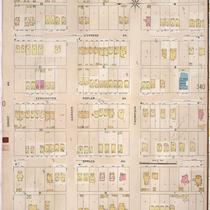
Southeastern part of early Kansas City from E. 20th Street south to E. 22nd Street and from Montgall Avenue east to Agnes Avenue, showing buildings, streets, and additions. Large numbers at edges of page refer to page with adjoining area.
-
Date
-
1896/1907
-
Object Type
-
Map
-
-
Title
-
Sanborn Map, Kansas City, Vol. 3, 1896-1907, Page p339
-
Description
-
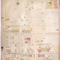
Northeastern part of early Kansas City from Smart Avenue south to Thompson Street and from Jackson Avenue east to Cypress Avenue, showing buildings, streets, and additions. Large numbers at edges of page refer to page with adjoining area.
-
Date
-
1896/1907
-
Object Type
-
Map
-

-
Title
-
Sanborn Map, Kansas City, Vol. 2, 1896-1907, Page p201
-
Description
-
Northeastern part of early Kansas City from Independence Avenue south to E. 8th Street and from about Indiana Avenue east to Cleveland Avenue, showing buildings, streets, and additions. Large numbers at edges of page refer to page with adjoining area.
-
Date
-
1896/1907
-
Object Type
-
Map
-

-
Title
-
Sanborn Map, Kansas City, Vol. 3, 1896-1907, Page p364
-
Description
-
Southeastern part of early Kansas City from E. 17th Street south to E. 19th Street and from Mersington Avenue east to Jackson Avenue, showing buildings, street,s and additions. Large numbers at edges of page refer to page with adjoining area. At top of map, "Add'l Sheet, Dec. 1901."
-
Date
-
1896/1907
-
Object Type
-
Map
-

-
Title
-
Sanborn Map, Kansas City, Vol. 2, 1896-1907, Page p117s
-
Description
-
Skeleton map of northern part of early Kansas City from E. 14th Street south to E. 16th Street and from Main Street east to McGee Street, showing outlines of buildings at the time of publication. These sheets were used to record new developments.
-
Date
-
1896/1907
-
Object Type
-
Map
-

-
Title
-
Sanborn Map, Kansas City, Vol. 2, 1896-1907, Page p158
-
Description
-
Northeastern part of early Kansas City from E. 12th Street south to E. 14th Street and from Vine Street east to Michigan Avenue, showing buildings, streets, and additions. Large numbers at edges of page refer to page with adjoining area.
-
Date
-
1896/1907
-
Object Type
-
Map
-

-
Title
-
Sanborn Map, Kansas City, Vol. 3, 1896-1907, Page p317
-
Description
-
Southeastern part of early Kansas City from E. 31st Street south to E. 32nd Street and from Oak Street east to Holmes Street, showing buildings, streets, and additions. Large numbers at edges of page refer to page with the adjoining area.
-
Date
-
1896/1907
-
Object Type
-
Map
-

-
Title
-
Sanborn Map, Kansas City, Vol. 2, 1896-1907, Page p141
-
Description
-
Northeastern part of early Kansas City from E. 10th Street south to E. 12th Street and from Harrison Street east to Tracy Avenue, showing buildings, streets, and additions. Large numbers at edges of page refer to page with adjoining area.
-
Date
-
1896/1907
-
Object Type
-
Map
-

-
Title
-
Sanborn Map, Kansas City, Vol. 2, 1896-1907, Page p133
-
Description
-
Northeastern part of early Kansas City from Independence Avenue south to Admiral Boulevard and from Holmes Street east to Harrison Street, showing buildings, streets, and additions. Large numbers at edges of page refer to page with adjoining area.
-
Date
-
1896/1907
-
Object Type
-
Map
-
-
Title
-
Sanborn Map, Kansas City, Vol. 2, 1896-1907, Page p147
-
Description
-
Northeastern part of early Kansas City from about E. 2nd Street south to E. 5th Street and from Troost Avenue east to Tracy Avenue, showing buildings, streets, and additions. Large numbers at edges of page refer to page with adjoining area.
-
Date
-
1896/1907
-
Object Type
-
Map
-

-
Title
-
Sanborn Map, Kansas City, Vol. 2, 1896-1907, Page p198
-
Description
-
Northeastern part of early Kansas City from E. 12th Street south to E. 14th Street and from Bellefontaine Avenue east to Indiana Avenue, showing buildings, streets, and additions. Large numbers at edges of page refer to page with adjoining area.
-
Date
-
1896/1907
-
Object Type
-
Map
-

-
Title
-
Sanborn Map, Kansas City, Vol. 2, 1896-1907, Page p218
-
Description
-
Northeastern part of early Kansas City from Rochester Avenue south to Edgar Avenue and from Euclid Avenue east to Warner Avenue, showing buildings, streets, and railroad lines. Large numbers at edges of page refer to page with adjoining area.
-
Date
-
1896/1907
-
Object Type
-
Map
-
-
Title
-
Sanborn Map, Kansas City, Vol. 3, 1896-1907, Page p350
-
Description
-
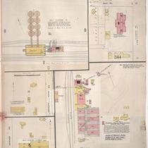
Northeastern part of early Kansas City near Independence, Missouri, in the industrial areas along the rail lines, showing buildings, streets, and railroad lines. Large numbers at edges of page refer to page with adjoining area.
-
Date
-
1896/1907
-
Object Type
-
Map
-

-
Title
-
Sanborn Map, Kansas City, Vol. 2, 1896-1907, Page p219
-
Description
-
Northeastern part of early Kansas City from about Guinotte Avenue south to about Saint John Avenue and from Lexington Avenue east to Highland Avenue, showing buildings, streets, and railroad lines. Large numbers at edges of page refer to page with adjoining area.
-
Date
-
1896/1907
-
Object Type
-
Map
-

-
Title
-
Sanborn Map, Kansas City, Vol. 3, 1896-1907, Page p313
-
Description
-
Southeastern part of early Kansas City from E. 30th Street south to E. 31st Street and from Cherry Street east to Campbell Street, as well as portions of the intersections of E. 26th and Michigan Avenue and E. 26th and Woodland Avenue. Large numbers at edges of page refer to page with adjoining area.
-
Date
-
1896/1907
-
Object Type
-
Map
-

-
Title
-
Sanborn Map, Kansas City, Vol. 2, 1896-1907, Page p116s
-
Description
-
Skeleton map of northern part of early Kansas City from E. 12th Street south to E. 14th Street and from Main Street east to McGee Street, showing outlines of buildings at the time of publication. These sheets were used to record new developments.
-
Date
-
1896/1907
-
Object Type
-
Map
-

-
Title
-
Sanborn Map, Kansas City, Vol. 3, 1896-1907, Page p284
-
Description
-
Southeastern part of early Kansas City from E. 24th Street south to E. 25th Street and from Tracy Avenue east to Vine Street, showing buildings, streets, and additions. Large numbers at edges of page refer to page with adjoining area.
-
Date
-
1896/1907
-
Object Type
-
Map
-

-
Title
-
Sanborn Map, Kansas City, Vol. 2, 1896-1907, Page p138
-
Description
-
Northeastern part of early Kansas City from E. 16th Street south to E. 18th Street and from Holmes Street east to Harrison Street, showing buildings, streets, and additions. Large numbers at edges of page refer to page with adjoining area.
-
Date
-
1896/1907
-
Object Type
-
Map
-

-
Title
-
Sanborn Map, Kansas City, Vol. 3, 1896-1907, Page p321
-
Description
-
Southeastern part of early Kansas City from E. 33rd Street south to E. 34th Street and from Campbell Street east to Forest Avenue, showing buildings, streets, and additions. Large numbers at edges of page refer to page with the adjoining area.
-
Date
-
1896/1907
-
Object Type
-
Map
-

-
Title
-
Sanborn Map, Kansas City, Vol. 2, 1896-1907, Page p135
-
Description
-
Northeastern part of early Kansas City from E. 10th Street south to E. 12th Street and from Holmes Street east to Harrison Street, showing buildings, streets, and additions. Large numbers at edges of page refer to page with adjoining area.
-
Date
-
1896/1907
-
Object Type
-
Map
Pages
