Pages
-

-
Title
-
Sanborn Map, Kansas City, Vol. 6, 1917-1957, Page p838
-
Description
-
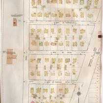
A portion of the Intercity District connecting Kansas City, Missouri, and Independence, Missouri, from Morrell Avenue south to Independence Avenue and from Overton Avenue east to Hardy Avenue, showing buildings, streets, and additions. Large numbers at edges of page refer to page with adjoining area.
-
Date
-
1917/1957
-
Object Type
-
Map
-
-
Title
-
Sanborn Map, Kansas City, Vol. 6, 1917-1957, Page p812
-
Description
-
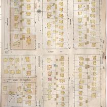
A portion of Kansas City from E. 55th Street south to E. 57th Street and from Main Street east to Brookside Boulevard, showing buildings, streets, and additions. Large numbers at edges of page refer to page with adjoining area.
-
Date
-
1917/1957
-
Object Type
-
Map
-

-
Title
-
Sanborn Map, Kansas City, Vol. 6, 1917-1957, Page p854
-
Description
-
A portion of the Intercity District between Kansas City, Missouri, and Independence, Missouri, from E. 11th Street south to E. 14th Street and from Glenwood Avenue east to Ralston Avenue, showing buildings, streets, and additions. Large numbers at edges of page refer to page with adjoining area. Noted at top of map, "Add'l Sheet, Nov. 1936. Independence."
-
Date
-
1917/1957
-
Object Type
-
Map
-

-
Title
-
Sanborn Map, Kansas City, Vol. 6, 1917-1957, Page p778
-
Description
-
A portion of northeastern Kansas City from E. 44th Street south to E. 45th Street and from Chestnut Avenue east to Bellefontaine Avenue, showing buildings, streets, and additions. Large numbers at edges of page refer to page with adjoining area.
-
Date
-
1917/1957
-
Object Type
-
Map
-

-
Title
-
Sanborn Map, Kansas City, Vol. 6, 1917-1957, Page p763
-
Description
-
A portion of northeastern Kansas City from E. 39th Street south to about E. 41st Street and from Michigan Avenue east to Brooklyn Avenue, showing buildings, streets, and additions. Large numbers at edges of page refer to page with adjoining area.
-
Date
-
1917/1957
-
Object Type
-
Map
-

-
Title
-
Sanborn Map, Kansas City, Vol. 6, 1917-1957, Page p785
-
Description
-
A portion of northeastern Kansas City from E. 49th Street south to about E. 51st Street and from Walrond Avenue east to Indiana Avenue, showing buildings, streets, and additions. Large numbers at edges of page refer to page with adjoining area.
-
Date
-
1917/1957
-
Object Type
-
Map
-

-
Title
-
Sanborn Map, Kansas City, Vol. 6, 1917-1957, Page p837
-
Description
-
A portion of the Intercity District connecting Kansas City, Missouri, and Independence, Missouri, from Morrell Avenue south to Independence Avenue and from Brookside Drive east to Overton Avenue, showing buildings, streets, and additions. Large numbers at edges of page refer to page with adjoining area.
-
Date
-
1917/1957
-
Object Type
-
Map
-

-
Title
-
Sanborn Map, Kansas City, Vol. 6, 1917-1957, Page p809
-
Description
-
A portion of Kansas City from W. 53rd Street south to W. 55th Street and from Wornall Road east to Baltimore Avenue, showing buildings, streets, and additions. Large numbers at edges of page refer to page with adjoining area.
-
Date
-
1917/1957
-
Object Type
-
Map
-

-
Title
-
Sanborn Map, Kansas City, Vol. 6, 1917-1957, Page p772
-
Description
-
A portion of northeastern Kansas City from E. 44th Street south to about E. 46th Street and from Michigan Avenue east to Brooklyn Avenue, showing buildings, streets, and additions. Large numbers at edges of page refer to page with adjoining area.
-
Date
-
1917/1957
-
Object Type
-
Map
-

-
Title
-
Sanborn Map, Kansas City, Vol. 6, 1917-1957, Page p764
-
Description
-
A portion of northeastern Kansas City from about E. 40th Street south to E. 42nd Street and from Michigan Avenue east to Brooklyn Avenue, showing buildings, streets, and additions. Large numbers at edges of page refer to page with adjoining area.
-
Date
-
1917/1957
-
Object Type
-
Map
-

-
Title
-
Sanborn Map, Kansas City, Vol. 6, 1917-1957, Page p754
-
Description
-
Portions of Kansas City showing Midwest Research Laboratories and Southeast High School, including streets and additions. Large numbers at edges of page refer to page with adjoining area. At top of page, "'NA' Apr. 1956."
-
Date
-
1917/1957
-
Object Type
-
Map
-

-
Title
-
Sanborn Map, Kansas City, Vol. 6, 1917-1957, Page p792
-
Description
-
A portion of eastern Kansas City from E. 67th Street south to E. 69th Street and from Myrtle Avenue east to Elmwood Avenue, showing buildings, streets, and additions. Separate sections show Hillcrest Country Club, George H. Nettleton Home for Aged Ladies, Park Gate, Associated Lumber and Millwork Company, and Blue Ridge Park. Large numbers at edges of page refer to page with adjoining area.
-
Date
-
1917/1957
-
Object Type
-
Map
-

-
Title
-
Sanborn Map, Kansas City, Vol. 6, 1917-1957, Page p852
-
Description
-
A portion of Kansas City from E. 50th Street south to E. 51st Street and from Grand Avenue east to Holmes and a portion from Volker Drive south to E. 51st Street and from Rockhill Road east to Lydia Avenue, showing buildings, streets, and additions. Large numbers at edges of page refer to page with adjoining area. Noted at top of page, "Add'l Sheet Dec. 1933."
-
Date
-
1917/1957
-
Object Type
-
Map
-
-
Title
-
Sanborn Map, Kansas City, Vol. 6, 1917-1957, Page p822
-
Description
-
A portion of Kansas City from E. 61st Street south to E. 63rd Street and from Walnut Street east to Oak Street, showing buildings, streets, and additions. Large numbers at edges of page refer to page with adjoining area.
-
Date
-
1917/1957
-
Object Type
-
Map
-

-
Title
-
Sanborn Map, Kansas City, Vol. 6, 1917-1957, Page p849
-
Description
-
A portion of Kansas City from just north of E. 44th Street south to E. 45th Street and from Bellefontaine Avenue east to Indiana Avenue, showing buildings, streets, and additions. Large numbers at edges of page refer to page with adjoining area. Noted at top of page, "New Sheet Dec. 1931."
-
Date
-
1917/1957
-
Object Type
-
Map
-

-
Title
-
Sanborn Map, Kansas City, Vol. 6, 1917-1957, Page p770
-
Description
-
A portion of northeastern Kansas City from E. 41st Street south to E. 42nd Street and from Chestnut Avenue east to Bellefontaine Avenue, showing buildings, streets, and additions. Large numbers at edges of page refer to page with adjoining area.
-
Date
-
1917/1957
-
Object Type
-
Map
-

-
Title
-
Sanborn Map, Kansas City, Vol. 6, 1917-1957, Page p753
-
Description
-
A portion of Kansas City from E. 31st Street south to E. 33rd Street and from Cleveland Avenue east to Poplar Avenue, showing buildings, streets, and additions. Large numbers at edges of page refer to page with adjoining area. At top of page, "(754, 851) 'X' Aug. 1941"
-
Date
-
1917/1957
-
Object Type
-
Map
-

-
Title
-
Sanborn Map, Kansas City, Vol. 6, 1917-1957, Page p808
-
Description
-
A portion of Kansas City from E. 54th Street south to E. 57th Street and from Westover Road east to Oak Street, showing buildings, streets, and additions. Large numbers at edges of page refer to page with adjoining area.
-
Date
-
1917/1957
-
Object Type
-
Map
-

-
Title
-
Sanborn Map, Kansas City, Vol. 6, 1917-1957, Page p816
-
Description
-
A portion of Kansas City from W. 58th Street south to Morningside Drive and from Brookside Boulevard east to Grand Avenue, showing buildings, streets, and additions. Large numbers at edges of page refer to page with adjoining area.
-
Date
-
1917/1957
-
Object Type
-
Map
-

-
Title
-
Sanborn Map, Kansas City, Vol. 6, 1917-1957, Page p818
-
Description
-
A portion of Kansas City from Huntington Road south to W. 61st Street Terrace and from Brookside Boulevard east to Walnut Street, showing buildings, streets, and additions. Large numbers at edges of page refer to page with adjoining area.
-
Date
-
1917/1957
-
Object Type
-
Map
Pages
