-

-
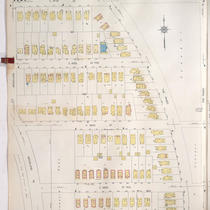
Title
-
Sanborn Map, Kansas City, Vol. 9, 1930-1957, Page p1012
-
Description
-
A portion of Kansas City from W. 73rd Street south to W. 76th Street Terrace and from Jarboe Street east to Pennsylvania Avenue, showing buildings, streets, and additions. Large numbers at edges of page refer to page with adjoining area.
-
Date
-
1930/1957
-
Object Type
-
Map
-

-
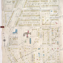
Title
-
Sanborn Map, Kansas City, Vol. 9, 1930-1957, Page p1105
-
Description
-
A portion of Kansas City from E. 69th Street south to E. 70th Street Terrace and from Woodland Avenue east to Paseo Boulevard, showing buildings, streets, and additions. Large numbers at edges of page refer to page with adjoining area.
-
Date
-
1930/1957
-
Object Type
-
Map
-
-
Title
-
Sanborn Map, Kansas City, Vol. 9, 1930-1957, Page p1101
-
Description
-
A portion of Kansas City from E. 67th Street south to E. 68th Street Terrace and from Woodland Avenue east to Paseo Boulevard, showing buildings, streets, and additions. Large numbers at edges of page refer to page with adjoining area.
-
Date
-
1930/1957
-
Object Type
-
Map
-
-
Title
-
Sanborn Map, Kansas City, Vol. 9, 1930-1957, Page p1111
-
Description
-
A portion of Kansas City from E. 70th Street Terrace south to E. 74th Street and from Paseo Boulevard east to Olive Street, showing buildings, streets, and additions. Large numbers at edges of page refer to page with adjoining area. At top of map, "Add'l Sheet, Jan. 1936."
-
Date
-
1930/1957
-
Object Type
-
Map
-

-
Title
-
Kansas City, Missouri
-
Description
-
Street map of Kansas City showing parks, cemeteries, park district boundaries, and street car lines.
-
Date
-
1940
-
Object Type
-
Map
-

-
Title
-
School Districts of Kansas City, Missouri
-
Description
-
Blue-line map of Kansas City, Missouri, showing boundaries for lower grade schools in the Kansas City School District. Map includes an inset showing high school boundaries. Map also shows parks, cemeteries, bodies of water, streets, boulevards, proposed parkways, railroads, and streetcar lines.
-
Date
-
1930
-
Object Type
-
Map
-
-
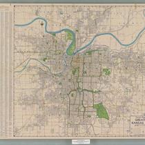
Title
-
Pocket Map of Greater Kansas City
-
Description
-
Road map of Kansas City and surrounding counties including Platte and Clay counties in Missouri, Wyandotte and Johnson counties in Kansas. Includes indexes to streets, public schools, and parochial schools.
-
Date
-
1950~
-
Object Type
-
Map
-

-
Title
-
Metropolitan Kansas City
-
Description
-
Street map of metropolitan Kansas City, with inset maps of Olathe, Kansas and Lee's Summit, Missouri. Features colored areas showing light and heavy industry, with many named industrial districts, city and school district boundaries, "switching limits."
-
Date
-
1960
-
Object Type
-
Map
-

-
Title
-
Kansas City, Missouri School District
-
Description
-
Blue-line street map of Kansas City, Missouri, showing the boundaries of the Kansas City School District. Map also depicts public schools, parochial schools, hospitals, police stations, parks, cemeteries, golf courses, bodies of water, railroads, and significant buildings.
-
Date
-
1958
-
Object Type
-
Map
-

-
Title
-
Proposed Master Plan
-
Description
-
Proposed master plan for Kansas City, Missouri development, including highways, thoroughfares, neighborhood boundaries, residential areas, business & commercial areas, railroad and industrial areas, public spaces, and public schools and recreation areas. Map covers Kansas City, Missouri city limits south of the Missouri River, with connections shown to surrounding communities, including North Kansas City, Missouri, Johnson County, Kansas, and Raytown, Missouri.
-
Date
-
1946
-
Object Type
-
Map
-

-
Title
-
Map Showing the Park and Boulevard System of Kansas City, Missouri
-
Description
-
Map showing Kansas City's system of parks and boulevards. The city is divided into five parks districts: West Park, North Park, South Park, East Park, and Westport Park. Lists of parks with their areas in acres, boulevards with their distances in miles, and park drives with their distances in miles is included.
-
Date
-
1906
-
Object Type
-
Map
-

-
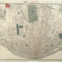
Title
-
Kansas City, Missouri - Zone Map
-
Description
-
Map of Kansas City, Missouri, showing zoning districts. A key to the districts is provided.
-
Date
-
1942-04-01
-
Object Type
-
Map
-

-
Title
-
Map of Kansas City Showing Park System and Extensions
-
Description
-
Map of Kansas City displaying the growth of the parks and boulevards system from 1893 through 1915. The first section is titled, Showing Original Study for Park System - 1893. The second section is titled, Showing Park System prior to the Extension of City Limits in 1909. The third section is titled, Showing Park System and Extensions to 1915. Item appears within the 1915 report of the Kansas City Board of Park and Boulevard Commissioners.
-
Date
-
1915
-
Object Type
-
Map
-
-
Title
-
Shewey's Map - City St. Louis
-
Description
-
Map of the city of St. Louis showing streets, parks, ward boundaries, public buildings and institutions, railroad lines and depots, the Mississippi River, and routes for cable cars, electric cars, horse cars, and proposed elevated lines. Includes an inset map of Carondelet.
-
Date
-
1890
-
Object Type
-
Map
-

-
Title
-
Tuttle Creek Reservoir - Big Blue River, Kansas
-
Description
-
Map of Tuttle Creek Reservoir showing surrounding towns, roads, and proposed recreation areas. Inset map shows reservoir's location in Kansas. Reverse of map includes project data, mileage from various locations, and recreation information.
-
Date
-
1961-05
-
Object Type
-
Map
-

-
Title
-
Plaza Area Plan Parks and Boulevards
-
Description
-
Map created by the Kansas City Landmarks Commission as part of a 1980s Plaza Plan presentation, encompassing an area from State Line Road east to The Paseo, and from Westport Road and 39th Street south to 55th Street. The map illustrates parks and boulevards within the area boundaries, including Westwood, Southmoreland, and Loose Parks, as well as the dates each park was established. Area plans, dealing with transportation, development, and zoning, among other factors, were developed over time for a number of Kansas City areas and are intended to provide guidance for their growth and design.
-
Date
-
1980~/1989~
-
Object Type
-
Map


