-
-
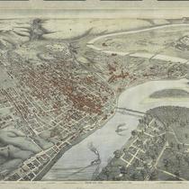
Title
-
Bird's Eye View - Kansas City
-
Description
-
Pictorial map showing the cities and towns of Kansas City, Missouri; Harlem, Missouri; Westport, Missouri; Rosedale, Kansas; Argentine, Kansas; Armourdale, Kansas; Armstrong, Kansas; Riverview, Kansas; Kansas City, Kansas; and Wyandotte, Kansas. At the time of its publication, the map had an extensive key listing the numbered buildings, most of which has been removed. Steamboats traveling along the Missouri River can be seen. The map displays the steep bluffs and topography of the region. It also indicates Kansas City's expansion southward away from the Missouri River, the development of the stockyards industry in the West Bottoms and interconnectivity with the surrounding cities and towns that followed completion of the Hannibal Bridge in 1869.
-
Date
-
1885~
-
Object Type
-
Map
-

-
Title
-
Map of the Kaw River and Vicinity
-
Description
-
Map of the Kaw River and Vicinity. Showing topography of channel, railroads, bridges, buildings, and adjacent streets. Compiled from original surveys made in conjunction with the investigation of floods in the Kaw River. "Plate 2" from set of 9 maps.
-
Date
-
1905
-
Object Type
-
Map
-

-
Title
-
Map of Live Stock Markets
-
Description
-
Map showing location of important public live stock markets and small live stock trading yards in western territory, n.d.
-
Object Type
-
Map
-

-
Title
-
Map of the Kansas City Stock Yards
-
Description
-
Map of the Kansas City Stock Yards showing classification of areas in yards and also land tracts, May 31, 1927 (revised by U.S. Dept. of Agriculture, Dec. 1929).
-
Date
-
1927-05-31
-
Object Type
-
Map
-

-
Title
-
Map of the Kansas City Stock Yards
-
Description
-
Map of the Kansas City Stock Yards vicinity with pens designated as Bull Dealers, Calf Dealers, Live Stock Commission Men, Cow Traders, and Steer Traders. The map also has individual names listed under each category.
-
Date
-
1917
-
Object Type
-
Map
-

-
Title
-
Frisco Lines
-
Description
-
Map of Frisco Lines in Kansas City, KS and Kansas City, MO, showing tracks in vicinity of Santa Fe Street and Packingtown Main, January 1, 1917. Map has “Recvd 10-26-30” written on it.
-
Date
-
1917-01-01
-
Object Type
-
Map
-

-
Title
-
Kansas City Terminal Railway
-
Description
-
Kansas City Terminal Railway Map showing accounting sections, Oct. 20, 1924 (revised March 1929)
-
Date
-
1924-10-20
-
Object Type
-
Map
