-

-
Title
-
Street and Water Department Buildings on Vine
-
Description
-
View looking northeast along Vine Street from its intersection with 21st Street of a stone Street Department building on the left and a stone Water Department building on the right. The Vine Street Kansas City Terminal Railway Viaduct is in view on the right.
-
Object Type
-
Photograph
-

-
Title
-
Bird's Eye View - Kansas City
-
Description
-
Pictorial map showing the cities and towns of Kansas City, Missouri; Harlem, Missouri; Westport, Missouri; Rosedale, Kansas; Argentine, Kansas; Armourdale, Kansas; Armstrong, Kansas; Riverview, Kansas; Kansas City, Kansas; and Wyandotte, Kansas. At the time of its publication, the map had an extensive key listing the numbered buildings, most of which has been removed. Steamboats traveling along the Missouri River can be seen. The map displays the steep bluffs and topography of the region. It also indicates Kansas City's expansion southward away from the Missouri River, the development of the stockyards industry in the West Bottoms and interconnectivity with the surrounding cities and towns that followed completion of the Hannibal Bridge in 1869.
-
Date
-
1885~
-
Object Type
-
Map
-
-
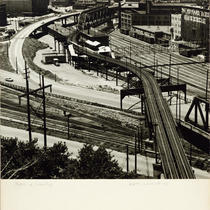
Title
-
Paths of Industry West Bottoms and 8th Street Tunnel Tracks
-
Description
-
View looking west into the West Bottoms from West Terrace Park in Quality Hill. The Bluff Street Bridge, buildings of the J. G. Peppard Seed Company, Kersey Coates Drive, and tracks leading to the Eighth Street Tunnel can be seen.
-
Date
-
1945~
-
Object Type
-
Photograph
-

-
Title
-
I-35 and Heart of America Bridge
-
Description
-
Photograph circa late 1980s taken from near the intersection of I-35 and the Heart of America Bridge, looking northwest at the River Market/Columbus Park area. The Cold Storage building is the blue sign in the background. The smoke stacks in the distance are on the old Power Plant at 1st and Grand Street.
-
Date
-
1980~/1989~
-
Object Type
-
Photograph
-

-
Title
-
River Market and North Kansas City
-
Description
-
Photograph taken from a elevated location of the River Market neighborhood, North Kansas City, the Missouri River, and the Downtown Airport circa 1990. The image appears to be taken from a building on the site currently occupied by Ilus W. Davis Park, which was cleared in 1994 and developed into a park and civic mall shortly thereafter. The United States Courthouse building, at 9th and Grand, can be seen in the lower left of the image. The Broadway Bridge is visible at far left, and the Heart of America Bridge, which opened in 1986, at right.
-
Date
-
1990~
-
Object Type
-
Photograph, Cityscapes
-

-
Title
-
Plaza Area Main Street Buildings
-
Description
-
Photograph looking north across Brush Creek and Ward Parkway of buildings along Main Street circa 1987. Fountain View (later American Century Investments north tower), at 4500 Main Street, One Main Plaza at 4435 Main, and the Marriott Hotel, at 4445 Main, are among the buildings pictured. The Plaza's Giralda Tower can be seen at the left side of the image.
-
Date
-
1987~
-
Object Type
-
Photograph
-

-
Title
-
Sixth Street Trafficway - Paseo Bridge Approach
-
Description
-
Elevated view looking southwest of the northeast corner of the downtown expressway look where 6th Street Trafficway meets the Paseo Bridge approach. The downtown skyline can be seen in the background. Cars traveling along the streets can be seen. A portion of the Columbus Park neighborhood is in view on the right hand side of the image.
-
Date
-
1954-10
-
Object Type
-
Photograph

