-
-
Title
-
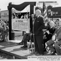
Westport Unveiling Ceremony
-
Description
-
Identified on photograph as "Mr. Woodard speaking at Westport unveiling ceremony, at the parkway at Broadway and Westport Road, June 5, 1950." The ceremony was held in conjunction with the Kansas City Centennial celebration. The historical marker in the photograph was erected by the Westport Historical Society.
-
Date
-
1950-06-05
-
Object Type
-
Photograph
-

-
Title
-
Historic Old Westport
-
Description
-
Map showing historic Westport, Missouri. Includes current and original street names, location of homes and businesses (including original and modern site, if relocated).
-
Object Type
-
Map
-

-
Title
-
Country Side 1908 Stone Marker
-
Description
-
Photograph, circa 1990s, of the stone marker which sits at the corner of East 52nd Street and Wyandotte Street. The stone marker has the words "Country Side" and "1908" on it. It was in 1908 that the Simpson-Yeomans family filed their first plats for Country Side and Country Side Extension. The triangular grassy island, in which the stone marker sits, is a design feature of the neighborhood, put in place by the original developers of the neighborhood, the Simpson-Yeoman family. Country Side Historic District was placed on the National Register of Historic Places in 1984.
-
Date
-
1990~/1999~
-
Object Type
-
Photograph
-

-
Title
-
Country Side 1908 Stone Marker
-
Description
-
Photograph, circa 1990s, of the stone marker which sits at the corner of West 52nd Street and Wyandotte Street. The stone marker has the words "Country Side" and "1908" on it. It was in 1908 that the Simpson-Yeomans family filed their first plats for Country Side and Country Side Extension. The triangular grassy island, in which the stone marker sits, is a design feature of the neighborhood, put in place by the original developers of the neighborhood, the Simpson-Yeoman family. Country Side Historic District was placed on the National Register of Historic Places in 1984.
-
Date
-
1980~/1989~
-
Object Type
-
Photograph
-

-
Title
-
Country Side 1908 Stone Marker
-
Description
-
Photograph, circa 1990s, of the stone marker which sits at the corner of East 52nd Street and Wyandotte Street. The stone marker has the words "Country Side" and "1908" on it. It was in 1908 that the Simpson-Yeomans family filed their first plats for Country Side and Country Side Extension. The triangular grassy island, in which the stone marker sits, is a design feature of the neighborhood, put in place by the original developers of the neighborhood, the Simpson-Yeoman family. Country Side Historic District was placed on the National Register of Historic Places in 1984.
-
Date
-
1980~/1989~
-
Object Type
-
Photograph
-

-
Title
-
Historical Landmarks, Trails & Monuments in and around Kansas City, Missouri
-
Description
-
Map created for the American Pioneer Trails Association with historical data provided by the Native Sons of Kansas City, Missouri, showing the locations of historical landmarks in the area. A Kawsmouth Chronology printed on the left hand side of the map provides a list of important dates in Kansas City history.
-
Date
-
1938
-
Object Type
-
Map
-
-
Title
-
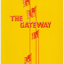
The Gateway Menu
-
Description
-
Menu for the Gateway restaurant, once located in a Holiday Inn hotel in Topeka, Kansas. An image of the Gateway to Kansas historical marker is printed on the menu's back cover.
-
Date
-
1970~
-
Object Type
-
Archival Material

