-

-
Title
-
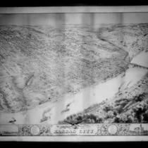
Bird's Eye View of Early Kansas City
-
Description
-
Framed (14 in. x 20 in.) map which is a reproduction of "Case & Norman's Stranger's Guide to Kansas City, Missouri." Caption at bottom reads: "To accommodate Kansas City newcomers, this 1887 map often rotated structures to present frontal views of buildings for easier identification." Map is a bird's eye view of Kansas City situated where the Kansas and Missouri Rivers converge. Includes an inset which is an advertisement for the National Agricultural Exposition held in 1887 and features the Crystal Palace or Exposition Building. This map was reproduced by the library's Marketing Department to sell in the early 1990s.
-
Date
-
1887
-
Object Type
-
Archival Material
-
-
Title
-
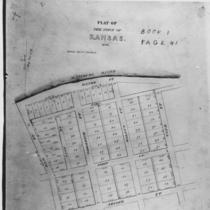
Town of Kansas Plat
-
Description
-
Photograph of the original plat map for the the Town of Kansas.
-
Date
-
1839
-
Object Type
-
Photograph
-

-
Title
-
Pictorial Map: Society Is Selling Photographic Reprints
-
Description
-
Photos and article about the news of the reprinting for sale of the Grinter pictorial map of Jackson County by the Jackson County Historical Society. Biographical information also about the map's creators, the late Mr. John Grinter (?-1960), a photographer and surveyor, and his wife Mrs. Sallie Grinter (ca. 1880-1967), a teacher and surveyor, both residents of Independence.
-
Date
-
1969
-
Object Type
-
Magazine Article
-
-
Title
-
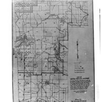
Battle of Westport Map
-
Description
-
Map of the Battle of Westport battlefield, drawn by William M. Lewis.
-
Object Type
-
Photograph