Pages
-

-
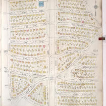
Title
-
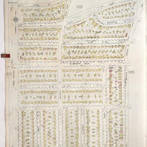
Sanborn Map, Kansas City, Vol. 9, 1930-1957, Page p0924
-
Description
-
A portion of Kansas City from E. 56th Street south to E. 57th Street and from Highland Avenue east to Euclid Avenue, showing buildings, streets, and additions. Large numbers at edges of page refer to page with adjoining area.
-
Date
-
1930/1957
-
Object Type
-
Map
-
-
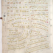
Title
-
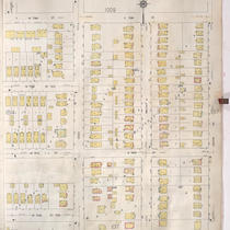
Sanborn Map, Kansas City, Vol. 9, 1930-1957, Page p1006
-
Description
-
A portion of Kansas City from W. 66th Street Terrace south to W. 70th Street and from Pennsylvania Avenue east to Linden Road, showing buildings, streets, and additions. Large numbers at edges of page refer to page with adjoining area.
-
Date
-
1930/1957
-
Object Type
-
Map
-

-
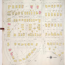
Title
-
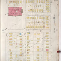
Sanborn Map, Kansas City, Vol. 9, 1930-1957, Page p1021
-
Description
-
A portion of Kansas City from Romany Road south to W. 73rd Street and from State Line Road east to Ward Parkway, showing buildings, streets, and additions. Large numbers at edges of page refer to page with adjoining area. At top of map, "Add'l Sheet, May 1940."
-
Date
-
1930/1957
-
Object Type
-
Map
-

-
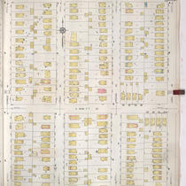
Title
-
Sanborn Map, Kansas City, Vol. 9, 1930-1957, Page p1012
-
Description
-
A portion of Kansas City from W. 73rd Street south to W. 76th Street Terrace and from Jarboe Street east to Pennsylvania Avenue, showing buildings, streets, and additions. Large numbers at edges of page refer to page with adjoining area.
-
Date
-
1930/1957
-
Object Type
-
Map
-

-
Title
-
Sanborn Map, Kansas City, Vol. 9, 1930-1957, Page p1019
-
Description
-
A portion of Kansas City from E. 66th Street Terrace south to E. 69th Street Terrace and from Oak Street east to Campbell Street, showing buildings, streets, and additions. Large numbers at edges of page refer to page with adjoining area. At top of map, "Add'l Sheet, June 1938."
-
Date
-
1930/1957
-
Object Type
-
Map
-

-
Title
-
Sanborn Map, Kansas City, Vol. 9, 1930-1957, Page p1018
-
Description
-
A portion of Kansas City from E. 69th Street Terrace south to E. 73rd Street and from Oak Street east to Campbell Street, showing buildings, streets, and additions. Large numbers at edges of page refer to page with adjoining area. At top of map, "Add'l Sheet, Jan. 1935."
-
Date
-
1930/1957
-
Object Type
-
Map
-

-
Title
-
Sanborn Map, Kansas City, Vol. 9, 1930-1957, Page p1002
-
Description
-
A portion of Kansas City from W. 63rd Street south to W. 66th Street Terrace and from Pennsylvania Avenue east to Baltimore Avenue, showing buildings, streets, and additions. Large numbers at edges of page refer to page with adjoining area.
-
Date
-
1930/1957
-
Object Type
-
Map
-
-
Title
-
Sanborn Map, Kansas City, Vol. 9, 1930-1957, Page p1005
-
Description
-
A portion of Kansas City from W. 66th Street Terrace south to W. 70th Street and from Ward Parkway east to Pennsylvania Avenue, showing buildings, streets, and additions. Large numbers at edges of page refer to page with adjoining area.
-
Date
-
1930/1957
-
Object Type
-
Map
-
-
Title
-
Sanborn Map, Kansas City, Vol. 9, 1930-1957, Page p0911
-
Description
-
A portion of Kansas City from E. 54th Street south to E. 55th Street and from Cherry Street east to Rockhill Road, showing buildings, streets, and additions. Large numbers at edges of page refer to page with adjoining area.
-
Date
-
1930/1957
-
Object Type
-
Map
-

-
Title
-
Sanborn Map, Kansas City, Vol. 9, 1930-1957, Page p0928
-
Description
-
A portion of Kansas City from E. 58th Street south to E. 59th Street and from Forest Avenue east to Paseo Boulevard, showing buildings, streets, and additions. Large numbers at edges of page refer to page with adjoining area.
-
Date
-
1930/1957
-
Object Type
-
Map
-

-
Title
-
Sanborn Map, Kansas City, Vol. 9, 1930-1957, Page p0908
-
Description
-
A portion of Kansas City from E. 53rd Street south to E. 54th Street and from Euclid Avenue east to Park Avenue, showing buildings, streets, and additions. Large numbers at edges of page refer to page with adjoining area.
-
Date
-
1930/1957
-
Object Type
-
Map
-

-
Title
-
Sanborn Map, Kansas City, Vol. 9, 1930-1957, Page p1004
-
Description
-
A portion of Kansas City from E. 66th Street Terrace south to E. 70th Street and from Linden Road east to Oak Street, showing buildings, streets, and additions. Large numbers at edges of page refer to page with adjoining area.
-
Date
-
1930/1957
-
Object Type
-
Map
-
-
Title
-
Sanborn Map, Kansas City, Vol. 9, 1930-1957, Page p0914
-
Description
-
A portion of Kansas City from E. 54th Street south to E. 55th Street and from Forest Avenue east to Lydia Avenue, showing buildings, streets, and additions. Large numbers at edges of page refer to page with adjoining area.
-
Date
-
1930/1957
-
Object Type
-
Map
-
-
Title
-
Sanborn Map, Kansas City, Vol. 9, 1930-1957, Page p1007
-
Description
-
A portion of Kansas City from Romany Road south to W. 73rd Street and from Ward Parkway east to Jefferson Street, showing buildings, streets, and additions. Large numbers at edges of page refer to page with adjoining area.
-
Date
-
1930/1957
-
Object Type
-
Map
-

-
Title
-
Sanborn Map, Kansas City, Vol. 9, 1930-1957, Page p1105
-
Description
-
A portion of Kansas City from E. 69th Street south to E. 70th Street Terrace and from Woodland Avenue east to Paseo Boulevard, showing buildings, streets, and additions. Large numbers at edges of page refer to page with adjoining area.
-
Date
-
1930/1957
-
Object Type
-
Map
-
-
Title
-
Sanborn Map, Kansas City, Vol. 9, 1930-1957, Page p1010
-
Description
-
A portion of Kansas City from E. 73rd Street south to E. 74th Street and from Main Street east to Grand Avenue, showing buildings, streets, and additions. Large numbers at edges of page refer to page with adjoining area.
-
Date
-
1930/1957
-
Object Type
-
Map
-
-
Title
-
Sanborn Map, Kansas City, Vol. 9, 1930-1957, Page p0936
-
Description
-
A portion of Kansas City from E. 59th Street south to E. 61st Street and from Forest Avenue east to Paseo Boulevard, showing buildings, streets, and additions. Large numbers at edges of page refer to page with adjoining area.
-
Date
-
1930/1957
-
Object Type
-
Map
-

-
Title
-
Sanborn Map, Kansas City, Vol. 9, 1930-1957, Page p0929
-
Description
-
A portion of Kansas City from E. 58th Street south to E. 59th Street and from Lydia Avenue east to Highland Avenue, showing buildings, streets, and additions. Large numbers at edges of page refer to page with adjoining area.
-
Date
-
1930/1957
-
Object Type
-
Map
-

-
Title
-
Sanborn Map, Kansas City, Vol. 9, 1930-1957, Page p0930
-
Description
-
A portion of Kansas City from E. 58th Street south to E. 59th Street and from Highland Avenue east to Euclid Avenue, showing buildings, streets, and additions. Large numbers at edges of page refer to page with adjoining area.
-
Date
-
1930/1957
-
Object Type
-
Map
Pages

