-

-
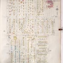
Title
-
Sanborn Map, Kansas City, Vol. 9, 1930-1957, Page p1025
-
Description
-
A portion of Kansas City from Charlotte Street east to Troost Avenue and E. 70th Street south to E. 76th Street Terrace, showing buildings, streets, and additions. Large numbers at edges of page refer to page with adjoining area.
-
Date
-
1930/1957
-
Object Type
-
Map
-
-
Title
-
Sanborn Map, Kansas City, Vol. 9, 1930-1957, Page p1012
-
Description
-
A portion of Kansas City from W. 73rd Street south to W. 76th Street Terrace and from Jarboe Street east to Pennsylvania Avenue, showing buildings, streets, and additions. Large numbers at edges of page refer to page with adjoining area.
-
Date
-
1930/1957
-
Object Type
-
Map
-

-
Title
-
Sanborn Map, Kansas City, Vol. 9, 1930-1957, Page p1015
-
Description
-
A portion of Kansas City from W. 75th Street south to W. 76th Street and from Jefferson Street east to Wornall Road, showing buildings, streets, and additions. Large numbers at edges of page refer to page with adjoining area.
-
Date
-
1930/1957
-
Object Type
-
Map
