Pages
-

-
Title
-
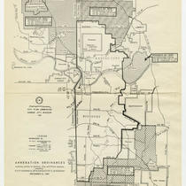
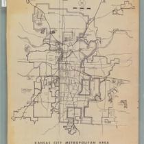
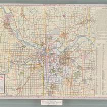
Kansas City Metropolitan Area
-
Description
-
Plat map of the greater Kansas City area, including north Independence and southern Clay County.
-
Date
-
1927
-
Object Type
-
Map
-

-
Title
-
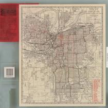
Zoning Map of Kansas City, Missouri
-
Description
-
Zoning map of Kansas City with shading indicating zoning districts. Key on map. "Red areas indicate the location of zoning changes during the period June 1952 to January 1956."
-
Date
-
1956
-
Object Type
-
Map
-
-
Title
-
Pocket Map of Greater Kansas City
-
Description
-
Road map of Kansas City and surrounding counties including Platte and Clay counties in Missouri, Wyandotte and Johnson counties in Kansas. Includes indexes to streets, public schools, and parochial schools.
-
Date
-
1950~
-
Object Type
-
Map
-

-
Title
-
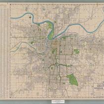
Greater Kansas City
-
Description
-
Road map of Kansas City and surrounding counties including Platte and Clay counties in Missouri, Wyandotte and Johnson counties in Kansas.
-
Date
-
1957
-
Object Type
-
Map
-
-
Title
-
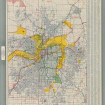
Metropolitan Kansas City
-
Description
-
Street map of metropolitan Kansas City, with inset maps of Olathe, Kansas and Lee's Summit, Missouri. Features colored areas showing light and heavy industry, with many named industrial districts, city and school district boundaries, "switching limits."
-
Date
-
1960
-
Object Type
-
Map
-
-
Title
-
Kansas City and Vicinity
-
Description
-
Road map of Kansas City and surrounding counties including Ray and Buchanan counties in Missouri, Johnson and Leavenworth counties in Kansas; enlarged maps of St. Joseph, Mo. and Leavenworth, Kan. inset. Reverse side is street map of metropolitan Kansas City. Includes indexes to towns, airports, golf clubs, cemeteries, parks, lakes, and streets.
-
Date
-
1960
-
Object Type
-
Map
-

-
Title
-
Geologic Cross Sections of Kansas City and Jackson County
-
Description
-
Six cross sections of areas of Jackson County, Missouri, and Kansas City, Missouri, illustrate altitude above sea level and types of bedrock. Labels display locations of creeks and rivers, as well as major city thoroughfares including Southwest Boulevard, Armour Boulevard, and 75th Street.
-
Object Type
-
Map
-

-
Title
-
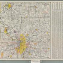
Greater Kansas City
-
Description
-
Road map of Kansas City and surrounding counties including Platte and Clay counties in Missouri, Wyandotte and Johnson counties in Kansas. Includes an index to streets.
-
Date
-
1961~
-
Object Type
-
Map
-
-
Title
-
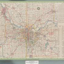
Kansas City Metropolitan Area
-
Description
-
Map of the Kansas City metropolitan area, showing boundaries of Kansas City and surrounding communities. Map also shows major roads and highways; proposed routes for Interstates 435, 35, 670, 635, and 470; proposed route for U.S. Highway 71; bodies of water; and airports.
-
Date
-
1960
-
Object Type
-
Map
-
-
Title
-
Official Map of Greater Kansas City
-
Description
-
Map of Kansas City, Missouri, Kansas City, Kansas, and North Kansas City indicating streets, motor coach lines and street railway lines. Reverse side includes a map of U.S. highways and state highways for greater Kansas City, as well as a map of Independence and Sugar Creek showing bus lines and street railroad lines.
-
Date
-
1942
-
Object Type
-
Map
-

-
Title
-
Map of the City of Kansas - Jackson County, Missouri
-
Description
-
Map of the City of Kansas, later known as Kansas City, in Jackson County, Missouri. Major streets, railroad lines, additions and subdivisions are marked. Landmarks and significant buildings are labeled. Harlem on the north side of the Missouri River in Clay County, Missouri, is shown.
-
Date
-
1880
-
Object Type
-
Map
-
-
Title
-
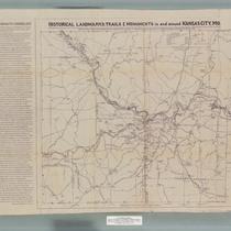
Historical Landmarks, Trails & Monuments in and around Kansas City, Missouri
-
Description
-
Map created for the American Pioneer Trails Association with historical data provided by the Native Sons of Kansas City, Missouri, showing the locations of historical landmarks in the area. A Kawsmouth Chronology printed on the left hand side of the map provides a list of important dates in Kansas City history.
-
Date
-
1938
-
Object Type
-
Map
-
-
Title
-
Kansas City Metropolitan Area: Tour with Cities Service
-
Description
-
Road map of Kansas City and vicinity; indexes nearby cities and towns, points of interest, lakes, parks, rivers, airports, golf and country clubs. Reverse side includes maps of metropolitan Kansas City, downtown Kansas City, and a sight-seeing guide with suggested tours.
-
Date
-
1957
-
Object Type
-
Map
-

-
Title
-
Kansas City Metropolitan Area: For People Going Places
-
Description
-
Road map of Kansas City and vicinity; indexes nearby cities and towns, points of interest, lakes, parks, rivers, airports, golf and country clubs. Reverse side includes maps of metropolitan Kansas City, downtown Kansas City, and a sight-seeing guide with suggested tours.
-
Date
-
1962
-
Object Type
-
Map
-
-
Title
-
Kansas City and Vicinity
-
Description
-
Road map of Kansas City and vicinity, including Platte and Clay Counties, and Johnson, Wyandotte and Leavenworth Counties in Kansas. Indexes nearby cities and towns, points of interest, golf and country clubs, airports, lakes, and rivers. Reverse side features maps of metropolitan and downtown Kansas City, as well as a map of a suggested sight-seeing tour, with principal buildings and parks indicated.
-
Date
-
1962
-
Object Type
-
Map
-

-
Title
-
Kansas City and Vicinity
-
Description
-
Road map of Kansas City and vicinity, including Platte and Clay Counties, and Johnson, Wyandotte and Leavenworth Counties in Kansas. Indexes nearby cities and towns, points of interest, golf and country clubs, airports, lakes, parks and rivers. Reverse side features maps of metropolitan and downtown Kansas City, as well as a map of a suggested sight-seeing tour, with major buildings and parks indicated.
-
Date
-
1961
-
Object Type
-
Map
-

-
Title
-
The Downtown Industrial Park
-
Description
-
Street map of metropolitan Kansas City, with the Downtown Industrial Park area indicated in red, and street index. Reverse side has enlarged map of industrial park (between 31st and 33rd Streets, just east of Kansas-Missouri state line), showing properties available to companies, as well as three companies already occupying space in the industrial park. Map of downtown business district with index to major buildings is also included.
-
Date
-
1961
-
Object Type
-
Map
-

-
Title
-
Map of Greater Kansas City
-
Description
-
Street map of metropolitan Kansas City, with street index. Reverse side includes map of downtown business district with index to major buildings, and a map of Kansas City and vicinity, with index to nearby cities and towns.
-
Date
-
1961
-
Object Type
-
Map
-
-
Title
-
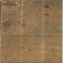
Edwards' Map of Jackson Co., Missouri
-
Description
-
Plat map of Jackson County, Missouri, and the southern extents of Clay County and Ray County, along the north bank of the Missouri River. Cities and towns, rivers, and parcels of land labeled with their owners' names are shown.
-
Date
-
1887
-
Object Type
-
Map
Pages