-

-
Title
-
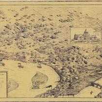
Bird's Eye View of Early Kansas City
-
Description
-
Framed (14 in. x 20 in.) map which is a reproduction of "Case & Norman's Stranger's Guide to Kansas City, Missouri." Caption at bottom reads: "To accommodate Kansas City newcomers, this 1887 map often rotated structures to present frontal views of buildings for easier identification." Map is a bird's eye view of Kansas City situated where the Kansas and Missouri Rivers converge. Includes an inset which is an advertisement for the National Agricultural Exposition held in 1887 and features the Crystal Palace or Exposition Building. This map was reproduced by the library's Marketing Department to sell in the early 1990s.
-
Date
-
1887
-
Object Type
-
Archival Material
-
-
Title
-
Case & Norman's Stranger's Guide to Kansas City, Missouri
-
Description
-
Aerial view of Kansas City seen from northwest. Shows streets, bridges, buildings, and railroads. Many buildings are identified. Continuation of title: ". . . showing principal points of interest correctly drawn and located, including most of the public buildings."
-
Date
-
1887
-
Object Type
-
Map
-

-
Title
-
Edwards' Map of Jackson Co., Missouri
-
Description
-
Plat map of Jackson County, Missouri, and the southern extents of Clay County and Ray County, along the north bank of the Missouri River. Cities and towns, rivers, and parcels of land labeled with their owners' names are shown.
-
Date
-
1887
-
Object Type
-
Map
