-

-
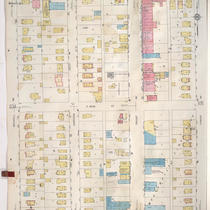
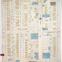
Title
-
Sanborn Map, Kansas City, Vol. 9, 1930-1957, Page p1112
-
Description
-
A portion of Kansas City from E. 63rd Street south to E. 66th Street Terrace and from Troost Avenue east to Paseo Boulevard, showing buildings, streets, and additions. Large numbers at edges of page refer to page with adjoining area. At top of map, "Add'l Sheet, May 1937."
-
Date
-
1930/1957
-
Object Type
-
Map
-

-
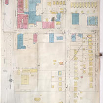
Title
-
Sanborn Map, Kansas City, Vol. 9, 1930-1957, Page p1025
-
Description
-
A portion of Kansas City from Charlotte Street east to Troost Avenue and E. 70th Street south to E. 76th Street Terrace, showing buildings, streets, and additions. Large numbers at edges of page refer to page with adjoining area.
-
Date
-
1930/1957
-
Object Type
-
Map
-
-
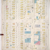
Title
-
Sanborn Map, Kansas City, Vol. 9, 1930-1957, Page p0935
-
Description
-
A portion of Kansas City from E. 59th Street south to E. 61st Street and from Rockhill Road east to Forest Avenue, showing buildings, streets, and additions. Large numbers at edges of page refer to page with adjoining area.
-
Date
-
1930/1957
-
Object Type
-
Map
-

-
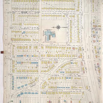
Title
-
Sanborn Map, Kansas City, Vol. 9, 1930-1957, Page p0943
-
Description
-
A portion of Kansas City from E. 55th Street south to E. 56th Street and from Park Avenue east to Prospect Avenue, showing buildings, streets, and additions. Large numbers at edges of page refer to page with adjoining area. At top of map, "Add'l Sheet, Jan. 1936."
-
Date
-
1930/1957
-
Object Type
-
Map
-

-
Title
-
Sanborn Map, Kansas City, Vol. 9, 1930-1957, Page p1008
-
Description
-
A portion of Kansas City from W. 70th Street south to W. 73rd Street and from Jefferson Street east to Baltimore Avenue, showing buildings, streets, and additions. Large numbers at edges of page refer to page with adjoining area. Country Club Lumber Company is noted on the map, but the 1939 city directory calls it the Snyder-Kunkel Lumber Company, 321 W. Gregory Blvd.
-
Date
-
1930/1957
-
Object Type
-
Map
-
-
Title
-
Sanborn Map, Kansas City, Vol. 9, 1930-1957, Page p1016
-
Description
-
A portion of Kansas City from W. 74th Street Terrace south to about W. 76th Street and from Wornall Road east to Baltimore Avenue, showing buildings, streets, and additions. Large numbers at edges of page refer to page with adjoining area.
-
Date
-
1930/1957
-
Object Type
-
Map
-

-
Title
-
Sanborn Map, Kansas City, Vol. 9, 1930-1957, Page p1023
-
Description
-
A portion of Kansas City from W. 77th Street south to W. 79th Street Terrace and from Pennsylvania Avenue east to Main Street, showing buildings, streets, and additions. Large numbers at edges of page refer to page with adjoining area. At top of map, "A. May 1941."
-
Date
-
1930/1957
-
Object Type
-
Map
-

-
Title
-
Sanborn Map, Kansas City, Vol. 9, 1930-1957, Page p1103
-
Description
-
A portion of Kansas City from E. 67th Street south to E. 68th Street Terrace and from Olive Street east to Montgall Avenue, showing buildings, streets, and additions. Large numbers at edges of page refer to page with adjoining area.
-
Date
-
1930/1957
-
Object Type
-
Map
-

-
Title
-
Sanborn Map, Kansas City, Vol. 9, 1930-1957, Page p0913
-
Description
-
A portion of Kansas City from E. 54th Street south to E. 55th Street and from Rockhill Road east to Forest Avenue, showing buildings, streets, and additions. Large numbers at edges of page refer to page with adjoining area.
-
Date
-
1930/1957
-
Object Type
-
Map
-
-
Title
-
Sanborn Map, Kansas City, Vol. 9, 1930-1957, Page p0927
-
Description
-
A portion of Kansas City from E. 58th Street south to E, 59th Street and from Rockhill Road east to Forest Avenue, showing buildings, streets, and additions. Large numbers at edges of page refer to page with adjoining area.
-
Date
-
1930/1957
-
Object Type
-
Map
-
-
Title
-
Sanborn Map, Kansas City, Vol. 9, 1930-1957, Page p1115
-
Description
-
A portion of Kansas City from E. 63rd Street south to Meyer Boulevard and from Prospect Avenue east to College Avenue, showing buildings, streets, and additions. Large numbers at edges of page refer to page with adjoining area.
-
Date
-
1930/1957
-
Object Type
-
Map
-
-
Title
-
Sanborn Map, Kansas City, Vol. 9, 1930-1957, Page p0939
-
Description
-
A portion of Kansas City from E. 61st Street south to E. 63rd Street and from Rockhill Road east to Forest Avenue, showing buildings, streets, and additions. Large numbers at edges of page refer to page with adjoining area.
-
Date
-
1930/1957
-
Object Type
-
Map
