-
-
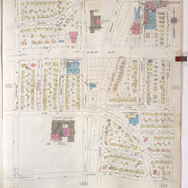
Title
-
Sanborn Map, Kansas City, Vol. 9, 1930-1957, Page p1002
-
Description
-
A portion of Kansas City from W. 63rd Street south to W. 66th Street Terrace and from Pennsylvania Avenue east to Baltimore Avenue, showing buildings, streets, and additions. Large numbers at edges of page refer to page with adjoining area.
-
Date
-
1930/1957
-
Object Type
-
Map
-

-
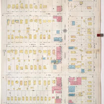
Title
-
Sanborn Map, Kansas City, Vol. 9, 1930-1957, Page p0940
-
Description
-
A portion of Kansas City from E. 61st Street south to E. 63rd Street and from Forest Avenue east to Paseo Boulevard, showing buildings, streets, and additions. Large numbers at edges of page refer to page with adjoining area.
-
Date
-
1930/1957
-
Object Type
-
Map
-
-
Title
-
Sanborn Map, Kansas City, Vol. 9, 1930-1957, Page p1104
-
Description
-
A portion of Kansas City from E. 69th Street south to E. 70th Street Terrace and from Olive Street east to Montgall Avenue, showing buildings, streets, and additions. Large numbers at edges of page refer to page with adjoining area.
-
Date
-
1930/1957
-
Object Type
-
Map
