-
-
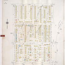
Title
-
Sanborn Map, Kansas City, Vol. 9, 1930-1957, Page p1119
-
Description
-
A portion of Kansas City from E. Gregory Boulevard south to E. 74th Street and from Lydia Avenue east to Paseo Boulevard and Woodland Avenue, showing buildings, streets, and additions. Large numbers at edges of page refer to page with adjoining area.
-
Date
-
1930/1957
-
Object Type
-
Map
-

-
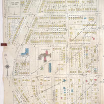
Title
-
Sanborn Map, Kansas City, Vol. 9, 1930-1957, Page p1025
-
Description
-
A portion of Kansas City from Charlotte Street east to Troost Avenue and E. 70th Street south to E. 76th Street Terrace, showing buildings, streets, and additions. Large numbers at edges of page refer to page with adjoining area.
-
Date
-
1930/1957
-
Object Type
-
Map
-

-
Title
-
Sanborn Map, Kansas City, Vol. 9, 1930-1957, Page p0942
-
Description
-
A portion of Kansas City from E. 59th Street south to E. 63rd Street and from Brooklyn Avenue east to Prospect Avenue, showing buildings, streets, and additions. Large numbers at edges of page refer to page with adjoining area.
-
Date
-
1930/1957
-
Object Type
-
Map
-
-
Title
-
Sanborn Map, Kansas City, Vol. 9, 1930-1957, Page p1111
-
Description
-
A portion of Kansas City from E. 70th Street Terrace south to E. 74th Street and from Paseo Boulevard east to Olive Street, showing buildings, streets, and additions. Large numbers at edges of page refer to page with adjoining area. At top of map, "Add'l Sheet, Jan. 1936."
-
Date
-
1930/1957
-
Object Type
-
Map
