-

-
Title
-
Housing Survey - Kansas City, Missouri - Negro Districts Map
-
Description
-
Map prepared by the Missouri Era Non-Manual Works Program, the City Plan Commission, and the Jackson County Emergency Relief Committee showing African American population centers in Kansas City in 1934. The map was included as part of the 1934-1935 Report of the Housing Survey of Kansas City, Missouri.
-
Date
-
1934
-
Object Type
-
Map
-

-
Title
-
Kansas City's Expressways
-
Description
-
Illustrated map showing the planned expressway system in the Kansas City area in 1952. Text printed on the map explains how the freeway system will work and how it will benefit the public. The map displays a plan to route the expressways close to the downtown area of Kansas City, Kansas, that was later changed.
-
Date
-
1952
-
Object Type
-
Map
-

-
Title
-
Construction Phases Map
-
Description
-
Map of the Kansas City area showing planned stages of consruction of the expressway system. The map was part of the City Plan Commission's publication Expressways - Greater Kansas City in 1951.
-
Date
-
1951
-
Object Type
-
Map
-
-
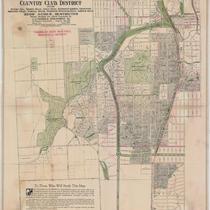
Title
-
Country Club District: 2500 Acres Restricted
-
Description
-
Title continues: "Including Sunset Hill, Mission Hills, Indian Hills, Hampstead Gardens, Crestwood, Greenway Fields, Wornall Manor, Westwood, Westwood Hills, and Armour Hills. 2,500 Acres Restricted. Planned, Developed and offered Exclusively by J. C. Nichols Investment Co." Plat map of the Country Club District, showing dimensions for each plot and sites for some proposed structures.
-
Date
-
1922-08
-
Object Type
-
Map

