-
-
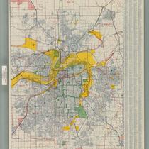
Title
-
Metropolitan Kansas City
-
Description
-
Street map of metropolitan Kansas City, with inset maps of Olathe, Kansas and Lee's Summit, Missouri. Features colored areas showing light and heavy industry, with many named industrial districts, city and school district boundaries, "switching limits."
-
Date
-
1960
-
Object Type
-
Map
-

-
Title
-
Bird's Eye View of Early Kansas City
-
Description
-
Framed (14 in. x 20 in.) map which is a reproduction of "Case & Norman's Stranger's Guide to Kansas City, Missouri." Caption at bottom reads: "To accommodate Kansas City newcomers, this 1887 map often rotated structures to present frontal views of buildings for easier identification." Map is a bird's eye view of Kansas City situated where the Kansas and Missouri Rivers converge. Includes an inset which is an advertisement for the National Agricultural Exposition held in 1887 and features the Crystal Palace or Exposition Building. This map was reproduced by the library's Marketing Department to sell in the early 1990s.
-
Date
-
1887
-
Object Type
-
Archival Material
-

-
Title
-
Case & Norman's Stranger's Guide to Kansas City, Missouri
-
Description
-
Aerial view of Kansas City seen from northwest. Shows streets, bridges, buildings, and railroads. Many buildings are identified. Continuation of title: ". . . showing principal points of interest correctly drawn and located, including most of the public buildings."
-
Date
-
1887
-
Object Type
-
Map
-

-
Title
-
Bird's Eye View of Kansas City, Missouri
-
Description
-
Sepia-toned aerial view from the northeast, showing the Missouri River, Hannibal Bridge, and the city of Kansas City with streets and buildings marked. Points of interest (churches, etc.) numbered; key on back of map. Also on the back is handwritten, "Star, Sept. 30, 1928."
-
Date
-
1869
-
Object Type
-
Map
-

-
Title
-
Plaza Area Plan Existing Circulation
-
Description
-
Map created by the Kansas City Landmarks Commission as part of a 1980s Plaza Plan presentation, encompassing an area from State Line Road east to The Paseo, and from Westport Road and 39th Street south to 55th Street. The map illustrates existing traffic circulation, including problem intersections such as the intersection of Southwest Trafficway and 39th Street. Area plans, dealing with transportation, development, and zoning, among other factors, were developed over time for a number of Kansas City areas and are intended to provide guidance for their growth and design.
-
Date
-
1980~/1989~
-
Object Type
-
Map
-

-
Title
-
Plaza Area Plan Parks and Boulevards
-
Description
-
Map created by the Kansas City Landmarks Commission as part of a 1980s Plaza Plan presentation, encompassing an area from State Line Road east to The Paseo, and from Westport Road and 39th Street south to 55th Street. The map illustrates parks and boulevards within the area boundaries, including Westwood, Southmoreland, and Loose Parks, as well as the dates each park was established. Area plans, dealing with transportation, development, and zoning, among other factors, were developed over time for a number of Kansas City areas and are intended to provide guidance for their growth and design.
-
Date
-
1980~/1989~
-
Object Type
-
Map


