Pages
-
-
Title
-
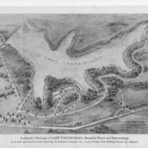
Architect's Drawing of Lake Tapawingo, (Beautiful Place) and Surroundings
-
Description
-
Architect's drawing of projected Lake Tapawingo, "Beautiful Place," and surroundings. One side of map is a bird's eye view of the area around the lake showing planned features such as club house and bathing beaches. The other side shows platting of lots. The development was "To be built and owned by the Lake Tapawingo Development Company, Inc., 513-515 Pioneer Trust Building, Kansas City, Missouri." Handwritten on top in pencil, "Lake Tapawingo, Mo. 1928." Date otherwise not noted.
-
Date
-
1928~
-
Object Type
-
Map
-
-
Title
-
Battle of Westport Map
-
Description
-
Map of the Battle of Westport battlefield, drawn by William M. Lewis.
-
Object Type
-
Photograph
-

-
Title
-
Bird's Eye View - Kansas City
-
Description
-
Pictorial map showing the cities and towns of Kansas City, Missouri; Harlem, Missouri; Westport, Missouri; Rosedale, Kansas; Argentine, Kansas; Armourdale, Kansas; Armstrong, Kansas; Riverview, Kansas; Kansas City, Kansas; and Wyandotte, Kansas. At the time of its publication, the map had an extensive key listing the numbered buildings, most of which has been removed. Steamboats traveling along the Missouri River can be seen. The map displays the steep bluffs and topography of the region. It also indicates Kansas City's expansion southward away from the Missouri River, the development of the stockyards industry in the West Bottoms and interconnectivity with the surrounding cities and towns that followed completion of the Hannibal Bridge in 1869.
-
Date
-
1885~
-
Object Type
-
Map
-

-
Title
-
Bird's Eye View of Early Kansas City
-
Description
-
Framed (14 in. x 20 in.) map which is a reproduction of "Case & Norman's Stranger's Guide to Kansas City, Missouri." Caption at bottom reads: "To accommodate Kansas City newcomers, this 1887 map often rotated structures to present frontal views of buildings for easier identification." Map is a bird's eye view of Kansas City situated where the Kansas and Missouri Rivers converge. Includes an inset which is an advertisement for the National Agricultural Exposition held in 1887 and features the Crystal Palace or Exposition Building. This map was reproduced by the library's Marketing Department to sell in the early 1990s.
-
Date
-
1887
-
Object Type
-
Archival Material
-

-
Title
-
Bird's Eye View of Kansas City, Missouri
-
Description
-
Aerial view of Kansas City from the northeast. Buildings, railroad lines, and other features rendered pictorially. Key at bottom of map identifies churches, schools, reservoirs, businesses, etc. Street names are shown. Hannibal Bridge is shown open for river traffic.
-
Date
-
1878
-
Object Type
-
Map
-

-
Title
-
Bird's Eye View of Kansas City, Missouri
-
Description
-
Aerial view of Kansas City from the northeast. Buildings, railroad lines, and other features are rendered pictorially. Key at bottom of map identifies churches, schools, reservoirs, businesses, etc. Street names are shown. The Hannibal Bridge is shown open for river traffic.Typed note taped to back of map reads, "George Ehrlich did extensive research to determine the date of this map - 1878 lithograph, Bird's Eye View, for his 1979 book "Kansas City, Mo.: An Architectural History, 1826-1976."
-
Date
-
1878
-
Object Type
-
Map
-

-
Title
-
Bird's Eye View of Kansas City, Missouri
-
Description
-
Sepia-toned aerial view from the northeast, showing the Missouri River, Hannibal Bridge, and the city of Kansas City with streets and buildings marked. Points of interest (churches, etc.) numbered; key on back of map. Also on the back is handwritten, "Star, Sept. 30, 1928."
-
Date
-
1869
-
Object Type
-
Map
-

-
Title
-
Brush Creek Project Pedestrians Open Space Connections in the Northeast Quadrant
-
Description
-
Map created by the Kansas City Landmarks Commission as part of a 1980s Brush Creek redesign presentation. The map illustrates parks and street connections between 43rd and 50th Streets on the north and south, and Broadway Boulevard and The Paseo on the west and east. Through the 1980s and early 1990s, the city undertook a major redesign of Brush Creek and adjacent areas aimed at beautification and improved flood control.
-
Date
-
1980~/1989~
-
Object Type
-
Map
-

-
Title
-
Brush Creek Project Plan
-
Description
-
Map created by the Kansas City Landmarks Commission as part of a 1980s Brush Creek redesign presentation. The map marks the location of the Brush Creek area on a map of Kansas City, Missouri. Through the 1980s and early 1990s, the city undertook a major redesign of Brush Creek and adjacent areas aimed at beautification and improved flood control.
-
Date
-
1980~/1989~
-
Object Type
-
Map
-

-
Title
-
Brush Creek Project Residential Actions
-
Description
-
Map created by the Kansas City Landmarks Commission as part of a 1980s Brush Creek redesign presentation, encompassing an area from State Line Road east to The Paseo, and from 43rd Street south to 55th Street. The map denotes smaller areas with numbers 1-4, but does not include a key. Through the 1980s and early 1990s, the city undertook a major redesign of Brush Creek and adjacent areas aimed at beautification and improved flood control.
-
Date
-
1980~/1989~
-
Object Type
-
Map
-

-
Title
-
Case & Norman's Stranger's Guide to Kansas City, Missouri
-
Description
-
Aerial view of Kansas City seen from northwest. Shows streets, bridges, buildings, and railroads. Many buildings are identified. Continuation of title: ". . . showing principal points of interest correctly drawn and located, including most of the public buildings."
-
Date
-
1887
-
Object Type
-
Map
-

-
Title
-
Clay County, Missouri
-
Description
-
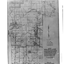
Land ownership map of Clay County, Missouri, showing U.S. highways, state and county roads, paved, graveled and graded roads, railroads, abandoned railroads, political township boundaries, twp. & range lines, future city limits, schools, churches, rivers and streams. Includes the townships of Kearney, Washington, Platte, Liberty, Gallatin, and Fishing River.
-
Date
-
1955~
-
Object Type
-
Map
-

-
Title
-
Construction Phases Map
-
Description
-
Map of the Kansas City area showing planned stages of consruction of the expressway system. The map was part of the City Plan Commission's publication Expressways - Greater Kansas City in 1951.
-
Date
-
1951
-
Object Type
-
Map
-
-
Title
-
The Country Club District
-
Description
-
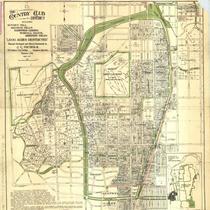
Title continues: "Including Sunset Hill, Mission Hills, Hampstead Gardens, Wornall Manor, and Greenway Fields, '1,500 Acres Restricted. Planned, Developed, and Offered Exclusively by J.C. Nichols." Street map of Country Club district and of Mission Hills, Kansas. Identifies property owners. Inset map of Kansas City shows relative location.
-
Date
-
1917-04
-
Object Type
-
Map
-
-
Title
-
Country Club District: 2500 Acres Restricted
-
Description
-
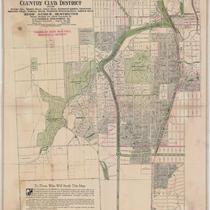
Title continues: "Including Sunset Hill, Mission Hills, Indian Hills, Hampstead Gardens, Crestwood, Greenway Fields, Wornall Manor, Westwood, Westwood Hills, and Armour Hills. 2,500 Acres Restricted. Planned, Developed and offered Exclusively by J. C. Nichols Investment Co." Plat map of the Country Club District, showing dimensions for each plot and sites for some proposed structures.
-
Date
-
1922-08
-
Object Type
-
Map
Pages


