-
-
Title
-
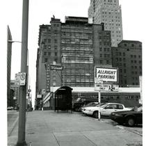
Buildings on Grand Avenue from 8th
-
Description
-
View looking southwest of building along Grand Avenue from its intersection with 8th Street. Cars parked in a lot can be seen. Signs for Allright Parking and Midwest Typewriter are in view. The Scarritt Building on Grand Avenue can be seen in the center of the image. The Scarritt Arcade Building on Walnut Street is in view on the right hand side of the image. The Fidelity National Bank Building is in view in the background.
-
Date
-
1990~
-
Object Type
-
Photograph
-

-
Title
-
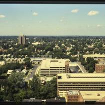
J. C. Nichols Parkway Apartments
-
Description
-
Photograph looking west from the top of the Fountain View (later American Century Investments north tower) of apartments and other buildings along and west of J. C. Nichols Parkway, circa 1987. Three of the six foreground apartment buildings were later demolished for a new townhome project. The Parkway Towers apartment building can be seen at the left edge of the image, and parking garages for the St. Luke's Hospital campus are visible at the right edge of the image.
-
Date
-
1980~/1989~
-
Object Type
-
Photograph
-

-
Title
-
Nichols Road Courtyard
-
Description
-
Photograph of the Plaza Court of the Penguins courtyard at the northeast corner of Nichols Road and Pennsylvania Avenue in the 1980s. A Kansas City Trolley Corp. trolley, on Nichols Road, is pictured dropping a passenger off at a stop. The company operated free trolleys, circulating riders through Downtown, Crown Center, Westport, and the Plaza beginning in 1984 through the mid-1990s.
-
Date
-
1980~/1989~
-
Object Type
-
Photograph
-

-
Title
-
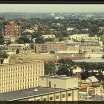
Plaza Aerial View
-
Description
-
Aerial photograph looking west along 47th Street in the 1980s, Main Street west to Jarboe Street. The Nelson-Atkins Museum's grounds can be seen in the lower right, with Westwood, Kansas, at the top edge. Brush Creek is visible at the left of the image, with Plaza commercial and residential buildings filling the bulk of the picture.
-
Date
-
1980~/1989~
-
Object Type
-
Photograph, Cityscapes
-

-
Title
-
Aladdin Hotel Construction
-
Description
-
View looking northeast of the construction of the Aladdin Hotel at 1215 Wyandotte Street. Cars parked along Wyandotte Street can be seen. Signs for parking lots and the Down-Town Garage are in view. a portion of the Down-Town Garage Building can be seen on the right hand side of the image.
-
Date
-
1925~
-
Object Type
-
Photograph
-

-
Title
-
Embassy Suites and Westport
-
Description
-
Photograph, looking northwest from the top of the Fountain View (later American Century Investments north tower), toward Westport circa 1987. The Embassy Suites hotel, at at 220 West 43rd Street, occupies the center of the image, with commercial buildings in Westport occupying the background of the image. J. C. Nichols Parkway curves through the upper right, and a building on the St. Luke's Hospital campus occupies the lower left.
-
Date
-
1987~
-
Object Type
-
Photograph
-

-
Title
-
Main Street Buildings and Southmoreland
-
Description
-
Photograph, looking east from the top of the Fountain View (later American Century Investments north tower), circa 1987. One Main Plaza office building occupies the left side of the image, and the Marriott Hotel on the right. The Southmoreland neighborhood and Kansas City Art Institute campus are visible between the buildings.
-
Date
-
1987~
-
Object Type
-
Photograph
-

-
Title
-
South Plaza Buildings
-
Description
-
Photograph of buildings in the South Plaza neighborhood, looking southwest from a parking lot in the 4900 block of Main Street circa 1987. The 4900 Main Building, which includes United Missouri Bank as a tenant, is pictured at the right edge of the image. A parking garage stands to the west, and the Sulgrave Apartments building is pictured to the north.
-
Date
-
1987~
-
Object Type
-
Photograph
-

-
Title
-
4700 Pennsylvania Avenue
-
Description
-
Photograph circa 1980s looking south of the parking lot and parking garage at 4700 Pennsylvania Avenue, on the southwest corner of Pennsylvania and 47th Street. At the time of photo, the lot was attached to Saks Fifth Avenue, that faced Nichols Road. As of 2017. Located in the Plaza neighborhood.
-
Date
-
1980~/1989~
-
Object Type
-
Photograph
-

-
Title
-
Marriott Hotel Main Street
-
Description
-
Photograph, looking east from the top of the Fountain View (later American Century Investments north tower), of the Marriott Hotel at 4445 Main Street circa 1987. The hotel stands on the northeast corner of 45th and Main Streets.
-
Date
-
1980~/1989~
-
Object Type
-
Photograph
-

-
Title
-
St. Luke's Hospital
-
Description
-
Photograph looking west from the top of the Fountain View (later American Century Investments north tower) St. Luke's Hospital buildings along J. C. Nichols Parkway, circa 1987.
-
Date
-
1987~
-
Object Type
-
Photograph
-
-
Title
-
St. Luke's and West Plaza
-
Description
-
Photograph looking west from the top of the Fountain View (later American Century Investments north tower) across the St. Luke's Hospital campus along J. C. Nichols Parkway, circa 1987. The Plaza West office building, at 4600 Madison, is visible in the background.
-
Date
-
1987~
-
Object Type
-
Photograph
-

-
Title
-
Down-town Garage
-
Description
-
Elevated view looking northeast of the construction of a Down-Town Garage at 1219 Wyandotte Street. The building was completed in 1922. Signs for the Gayety Theater and the Fogel Construction Company are in view. Three figures are standing atop the structure. A small portion of the Kansas City Club Building can be seen on the right hand side of the image. The image caption reads: Down Town Garage. Hans Von Unwerth, Engineers - Fogel Construction Company Contractors - Haydite Aggregate sold by the Haydite Company.
-
Date
-
1922~
-
Object Type
-
Photograph
-

-
Title
-
Plaza Residential and Commercial Buildings
-
Description
-
Photograph looking west from the top of the Fountain View (later American Century Investments north tower) of apartments, houses, other buildings west of J. C. Nichols Parkway, circa 1987. The Plaza West office tower, at 4600 Madison, can be seen in the background of the image. St. Luke's Hospital parking garages are visible at right, and Plaza-area residential and commercial buildings fill the majority of the image.
-
Date
-
1987~
-
Object Type
-
Photograph
-
-
Title
-
Elevated View of Westport and St. Luke's Hospital
-
Description
-
Photograph looking northwest from the top of the Fountain View building (later American Century north tower) of the St. Luke's Hospital campus, and buildings in Westport beyond, circa 1987. Hospital buildings occupy the foreground of the image, with the Allen School building and the Westport House senior apartments visible in the background left.
-
Date
-
1980~/1989~
-
Object Type
-
Photograph
-
-
Title
-
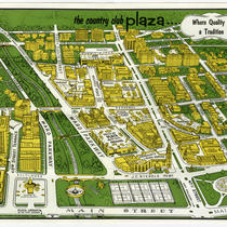
Map of the Country Club Plaza
-
Description
-
Tour and store directory map for the Country Club Plaza shopping center. A note records that the illustration is based on an original 1947 map and revised of January 1967. Significant Plaza buildings, shops and amenities are shown. The reverse side provides a directory of retail and service shops with addresses and telephone exchange numbers. A text description of the Country Club Plaza is also included.
-
Date
-
1967
-
Object Type
-
Map
-

-
Title
-
10th and Locust Garage and Storage - 924 Locust Street
-
Description
-
View looking west of the 10th and Locust Garage and Storage building that once stood at 924 Locust Street. A portion of the Locust Street Chili House building that once stood at 930 Locust Street can be seen on the left hand side of the image. A portion of the Densmore Hotel that once stood at 908-916 Locust Street is in view on the right hand side of the image.
-
Date
-
1940~
-
Object Type
-
Photograph
-

-
Title
-
Main Street
-
Description
-
Street level view of the west side of Main Street between 13th to 14th streets in downtown Kansas City, Missouri. View is looking toward the southwest. Included in the view is the Keystone Building housing Hurst Sporting Goods and a portion of the Empire Theater located at the southwest corner of 14th and Main streets. Also in view is a parking garage with Soakie's Famous Sandwiches located on the first floor. Area became part of the Power and Light District.
-
Date
-
1999
-
Object Type
-
Photograph
