-
-
Title
-
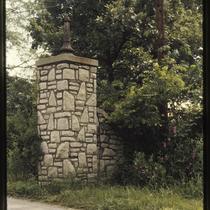
Excelsior Springs Stone Gateway
-
Description
-
Photograph of stone structure acting as a gateway along an unidentified Excelsior Springs road in the 1980s.
-
Date
-
1980~/1989~
-
Object Type
-
Photograph
-

-
Title
-
Swope Park Shelter House #1
-
Description
-
Photograph of Swope Park Shelter House Number 1, located to the southeast of the main entrance to Swope Park in Kansas City, Missouri. This vantage point faces west from the footpaths on the west side of the building.
-
Date
-
1980~/1989~
-
Object Type
-
Photograph
-
-
Title
-
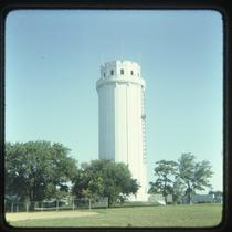
Waldo Water Tower
-
Description
-
Photograph of the Waldo Water Tower in Tower Park in the 1980s. The water tower was constructed in 1920 and used until 1957, and was originally called the Frank T. Riley Memorial after the owner of the property on which it was built.
-
Date
-
1980~/1989~
-
Object Type
-
Photograph
-

-
Title
-
Theis Park
-
Description
-
Photograph of the lawn at Theis Park, looking west toward the Plaza, circa 1987. The Sulgrave Apartments building is visible in the background.
-
Date
-
1980~/1989~
-
Object Type
-
Photograph
-

-
Title
-
Cliff Drive
-
Description
-
Photograph of Cliff Drive Scenic Byway, looking south from an access road connecting Gladstone Boulevard, in the 1980s.
-
Date
-
1980~/1989~
-
Object Type
-
Photograph
-

-
Title
-
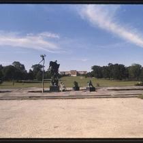
John F. Kennedy Memorial at Kessler Park
-
Description
-
Photograph of The Colonnade area of Kessler Park in the early 1980s, looking across St. John Avenue from its intersection with Gladstone Boulevard. A memorial to President John F. Kennedy, dedicated on May 29, 1965, can be seen at center.
-
Date
-
1980~/1989~
-
Object Type
-
Photograph
-

-
Title
-
Saint Luke's Hospital
-
Description
-
Photograph of St. Luke's Hospital, looking southwest from J. C. Nichols Parkway south of 43rd Street, during the 1980s. Mill Creek Park is in the foreground of the image. St. Luke's relocated to the site in 1923, and the building pictured was constructed in the 1960s.
-
Date
-
1980~/1989~
-
Object Type
-
Photograph
-

-
Title
-
Liberty Memorial
-
Description
-
Photograph of Liberty Memorial in the early 1980s. Other Kansas City buildings, including the Power & Light building, can be seen in the background. Built as a memorial to World War I, the monument and its attached museum were dedicated in 1926 and were designed by architect H. Van Buren Magonigle in Egyptian Revival style. Structural deterioration lead to the memorial being closed to the public in 1994. It was restored and reopened, with an expanded museum, in 2006.
-
Date
-
1980~/1989~
-
Object Type
-
Photograph
-

-
Title
-
Plaza and Midtown Satellite View
-
Description
-
Satellite image of the Plaza and surrounding areas in the 1980s. The photo spans from roughly 44th Street on the north to 52nd Street on the south, and Liberty Street on the west to Harrison Street on the east. Neighborhoods including the Plaza and Southmoreland are pictured, as are parks including Mill Creek Park, Southmoreland Park, and Gillham Park.
-
Date
-
1980~/1989~
-
Object Type
-
Photograph
-

-
Title
-
Plaza and Midtown Satellite View
-
Description
-
Satellite image of the Plaza and surrounding areas in the 1980s. The photo spans from roughly 42nd Street on the north to 48th Street on the south, and Genessee Street on the west to McGee Street on the east. Neighborhoods including the Plaza and Southmoreland are pictured, as are parks including Mill Creek Park and Southmoreland Park.
-
Date
-
1980~/1989~
-
Object Type
-
Photograph
-
-
Title
-
William Volker Memorial Fountain
-
Description
-
Photograph of the William Volker Memorial Fountain, looking north from the south end of Theis Park near the intersection of Oak Street and Volker Boulevard, in the early 1980s. The fountain, dedicated in 1958, was moved further south toward Volker in the 1990s as part of a redesign of Brush Creek and Theis Park. The Nelson Art Gallery building, at 4425 Oak Street, can be seen in the background of the image.
-
Date
-
1980~/1989~
-
Object Type
-
Photograph
-

-
Title
-
Main Street and J. C. Nichols Parkway at 47th Street
-
Description
-
Photograph, looking south from the top of the Fountain View (later American Century Investments north tower), toward the intersection of 47th Street with J. C. Nichols Parkway (at right) and Main Street (at left). Streetcar tracks can be seen running behind commercial buildings in the foreground, southeast diagonally across Main Street. Nichols Fountain, in Mill Creek Park, is visible at the center of the image. Main Street and Brookside Boulevard were later realigned as part of a Brush Creek beautification and flood control project in the 1990s. South Plaza apartment and office buildings are visible in the background of the image, with Country Club Plaza commercial and residential buildings in the foreground right.
-
Date
-
1980~/1989~
-
Object Type
-
Photograph
-

-
Title
-
Plaza and Midtown Satellite View
-
Description
-
Satellite image of the Plaza and surrounding areas in the 1980s. The photo spans from roughly 39th Street on the north to 52nd Street on the south, and Rainbow Boulevard in Kansas on the west to Paseo Boulevard on the east. Neighborhoods including the Plaza and Westport are pictured, as are parks including Mill Creek Park, Southmoreland Park, and Gillham Park.
-
Date
-
1980~/1989~
-
Object Type
-
Photograph
-

-
Title
-
Midwest Research Institute and Theis Park
-
Description
-
Photograph, looking southwest across a section of Theis Park, of the Midwest Research Institute building at 425 Volker Boulevard in the early 1980s.
-
Date
-
1980~/1989~
-
Object Type
-
Photograph
-

-
Title
-
Plaza and Midtown Satellite View
-
Description
-
Satellite image of the Plaza and surrounding areas in the 1980s. The photo spans from roughly 42nd Street on the north to 49th Street on the south, and Jefferson Street on the west to Tracy Avenue on the east. Neighborhoods including the Plaza and Southmoreland are pictured, as are parks including Mill Creek Park, Southmoreland Park, and Gillham Park.
-
Date
-
1980~/1989~
-
Object Type
-
Photograph
-

-
Title
-
Plaza Area Plan Parks and Boulevards
-
Description
-
Map created by the Kansas City Landmarks Commission as part of a 1980s Plaza Plan presentation, encompassing an area from State Line Road east to The Paseo, and from Westport Road and 39th Street south to 55th Street. The map illustrates parks and boulevards within the area boundaries, including Westwood, Southmoreland, and Loose Parks, as well as the dates each park was established. Area plans, dealing with transportation, development, and zoning, among other factors, were developed over time for a number of Kansas City areas and are intended to provide guidance for their growth and design.
-
Date
-
1980~/1989~
-
Object Type
-
Map
