Pages
-

-
Title
-
Brookside Sewer
-
Description
-
View looking north of the Brookside Boulevard sewer where it met 55th Street.
-
Date
-
1938-05
-
Object Type
-
Photograph
-
-
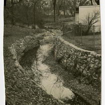
Title
-
Brookside Brook
-
Description
-
View of the stream that once ran alongside Brookside Boulevard.
-
Date
-
1933-11
-
Object Type
-
Photograph
-

-
Title
-
Bridge on Rockhill Road, Kansas City, Mo.
-
Description
-
Postcard showing the stone Rockhill Road Bridge that once spanned Brush Creek. The bridge had previously been known as the Nelson Bridge.
-
Date
-
1910
-
Object Type
-
Postcard
-
-
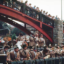
Title
-
Brush Creek Band
-
Description
-
View looking northwest of an unidentified big band playing in Brush Creek beneath a pedestrian bridge that crossed the stream at Central Street. Several concert attendees can be seen.
-
Date
-
1980~
-
Object Type
-
Photograph
-

-
Title
-
Maynard Ferguson in Brush Creek
-
Description
-
View looking northwest of Maynard Ferguson and his band playing in Brush Creek beneath a pedestrian bridge that crossed the stream at Central Street. Several concert attendees can be seen.
-
Date
-
1980~
-
Object Type
-
Photograph
-
-
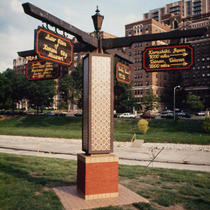
Title
-
Sister Cities Sign
-
Description
-
View looking southeast of a sister cities sign that once stood along Brush Creek's northern bank in the Country Club Plaza. The following cities are listed on the sign: Seville, Spain - 4700 miles; Freetown, Sierra Leone, Africa - 5000 miles; Kurashiki, Japan - 7000 miles; Tainan, Taiwan - 7500 miles; Morelia, Mexico - 1200 miles.
-
Date
-
1980~
-
Object Type
-
Photograph
-
-
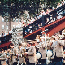
Title
-
Brush Creek Band
-
Description
-
View looking southwest of an unidentified big band playing in Brush Creek beneath a pedestrian bridge that crossed the stream at Central Street. Several concert attendees can be seen.
-
Date
-
1980~
-
Object Type
-
Photograph
-

-
Title
-
Brush Creek
-
Description
-
View of children and adults wading in Brush Creek in the Country Club Plaza.
-
Date
-
1980~
-
Object Type
-
Photograph
-

-
Title
-
Alameda Plaza Hotel
-
Description
-
View looking south along Wornall Road from its bridge over Brush Creek showing the Alameda Plaza Hotel at 401 Ward Parkway in the Country Club Plaza.
-
Date
-
1980~
-
Object Type
-
Photograph
-

-
Title
-
Historic Old Westport
-
Description
-
Map showing historic Westport, Missouri. Includes current and original street names, location of homes and businesses (including original and modern site, if relocated).
-
Object Type
-
Map
-

-
Title
-
Country Club Plaza
-
Description
-
Elevated view looking northwest of the Country Club Plaza. Brush Creek and Ward Parkway can be seen in the foreground.
-
Date
-
1940~
-
Object Type
-
Photograph
-
-
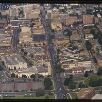
Title
-
Plaza Aerial View
-
Description
-
Aerial photograph looking west along 47th Street in the 1980s, Main Street west to Jarboe Street. The Nelson-Atkins Museum's grounds can be seen in the lower right, with Westwood, Kansas, at the top edge. Brush Creek is visible at the left of the image, with Plaza commercial and residential buildings filling the bulk of the picture.
-
Date
-
1980~/1989~
-
Object Type
-
Photograph, Cityscapes
-

-
Title
-
Indian Creek near Watts Mill
-
Description
-
View looking south of Indian Creek near the Watts Mill site.
-
Date
-
1960~
-
Object Type
-
Photograph
-
-
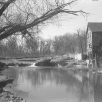
Title
-
Watts Mill
-
Description
-
View looking south of Watts Mill and Indian Creek.
-
Date
-
1960~
-
Object Type
-
Photograph
-

-
Title
-
Watts Mill
-
Description
-
View looking south of Watts Mill and Indian Creek.
-
Date
-
1960~
-
Object Type
-
Photograph
-

-
Title
-
Watts Mill
-
Description
-
View looking south of Watts Mill and Indian Creek.
-
Date
-
1960~
-
Object Type
-
Photograph
-

-
Title
-
Watts Mill
-
Description
-
View looking south of Watts Mill and Indian Creek.
-
Date
-
1960~
-
Object Type
-
Photograph
-

-
Title
-
Watts Mill
-
Description
-
View looking south of Watts Mill and Indian Creek.
-
Date
-
1960~
-
Object Type
-
Photograph
-

-
Title
-
Watts Mill
-
Description
-
View looking south of Watts Mill and Indian Creek.
-
Date
-
1960~
-
Object Type
-
Photograph
Pages

