-
-
Title
-
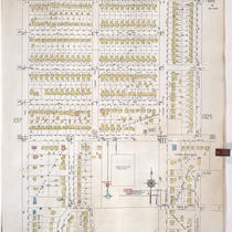
Sanborn Map, Kansas City, Vol. 9, 1930-1957, Page p1024
-
Description
-
A portion of Kansas City from E. 73rd Street south to E. 76th Street Oak Street east to Charlotte Street, showing buildings, streets, and additions. Large numbers at edges of page refer to page with adjoining area.
-
Date
-
1930/1957
-
Object Type
-
Map
-
-
Title
-
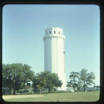
Waldo Water Tower
-
Description
-
Photograph of the Waldo Water Tower in Tower Park in the 1980s. The water tower was constructed in 1920 and used until 1957, and was originally called the Frank T. Riley Memorial after the owner of the property on which it was built.
-
Date
-
1980~/1989~
-
Object Type
-
Photograph
