-

-
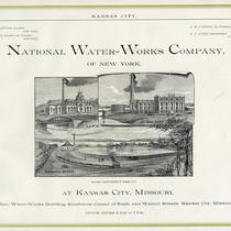
Title
-
Looking East over Water Works
-
Description
-
Aerial view facing east. The Kansas City Water Works Plant, Highway 9, and the city of North Kansas City, Missouri, can be seen.
-
Date
-
1963-10-11
-
Object Type
-
Photograph
-
-
Title
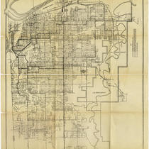
-
General Plan of Distribution System
-
Description
-
Map showing the water distribution system of Kansas City, Missouri, showing distribution lines, discharge lines, and low service lines. The Turkey Creek and proposed East Bottoms pumping stations and the Holly Street and Northeast reservoirs are indicated.
-
Date
-
1920
-
Object Type
-
Map
-

-
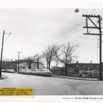
Title
-
40th Street: Looking West from Pennsylvania
-
Description
-
View of 40th Street facing west taken from its intersection with Pennsylvania Avenue in Westport. The Kansas City Water Works Repair Department Building can be seen on the south side of the street. Several parked cars and a delivery truck traveling east along 40th Street are in view.
-
Date
-
1950~
-
Object Type
-
Photograph
-
-
Title
-
Pennsylvania Looking Southwest showing KC Water Department Grounds
-
Description
-
View of the intersection of 40th Street and Pennsylvania Avenue facing southwest in Westport. An adult and child pedestrian can be seen walking on the sidewalk. Several cars parked along Pennsylvania Avenue are in view. Portions of the Kansas City Water Works grounds and the Manor Baking Company Building can be seen on the west side of the street.
-
Date
-
1950~
-
Object Type
-
Photograph