|
Map of Battle Field of Westport |
 |
Map depicting car lines, Union Army, confederate Army, known battery locations, and heavy fighting sabers. "Covering territory from Brush Creek on the North to Indian Creek on the South, and... |
|
Shewey's Map - City St. Louis |
 |
Map of the city of St. Louis showing streets, parks, ward boundaries, public buildings and institutions, railroad lines and depots, the Mississippi River, and routes for cable cars, electric cars,... |
|
1924 Road Map of Jackson County, MO. |
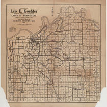 |
Map showing different types of roads (macadam, graded, oiled, and earth) as well as railroads, electric lines, section lines, towns, and streams in Jackson County, Missouri. |
|
Map of Missouri - Blair's Emancipation Map |
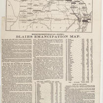 |
Map with text and tables containing data on slavery in Missouri. Data taken from the Missouri state census of 1856 gives the percentage of slaves in the population of each county. The material was... |
|
Plan of the Town of Newton in 1700 |
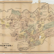 |
Map of the town of Newton, Massachusetts, showing plat ownership by early settlers, roads, ponds, meadows, and the Charles River. |
|
A Map of Lewis and Clark's Track, acrofs [across] the Western Portion of North America |
![A Map of Lewis and Clark's Track, acrofs [across] the Western Portion of North America](https://kchistory.org/sites/default/files/styles/islandora_imagecache_image_style_medium/public/externals/d1533d88de6b20b64edab4c9e2a5a093.jpg?itok=WF_VR5I6&pid=kchistory:20210802&iic=true) |
Facsimile of map showing Lewis and Clark's journey "from the Mississippi to the Pacific Ocean by Order of the Executive of the United States in 1804, 5 & 6." Native American tribal... |
|
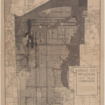
Kansas City Zoning Districts |
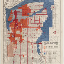 |
Map of Kansas City, Missouri, color-coded to show one family residence areas, two family residence areas, apartments, retail business districts, light industry districts, heavy industry districts,... |
|
Kansas City, Missouri - Zone Map |
 |
Map of Kansas City, Missouri, showing zoning districts. A key to the districts is provided. |
|
Proposed Master Plan |
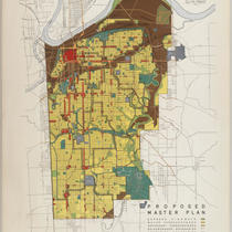 |
Proposed master plan for Kansas City, Missouri development, including highways, thoroughfares, neighborhood boundaries, residential areas, business & commercial areas, railroad and industrial... |
|
Colton's New Sectional Map of the State of Kansas Compiled from the United States Surveys and Other Authentic Sources |
 |
Map depicting counties and townships with sectional subdivisions, of the state of Kansas. Includes rivers and towns. |
|
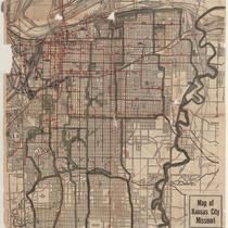
Kansas City, Missouri |
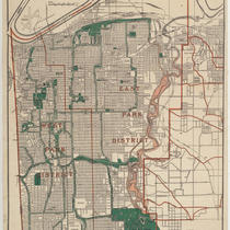 |
Street map of Kansas City showing parks, cemeteries, park district boundaries, and street car lines. |
|
Park & Boulevard System: Kansas City, Missouri |
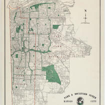 |
Street map of Kansas City showing parks, cemeteries, industrial districts, and park district boundaries. |
|
Soil Map of Missouri - Reconnaissance Survey |
 |
Survey map of the state of Missouri provides detailed regional information about soil types (silt, clay, sand, etc.). Also included are locations of cities, rivers and lakes, railroads, and county... |
|
Map of an Exploring Expedition to the Rocky Mountains in the Year 1842 - Oregon * North California in the Years 1843-44 |
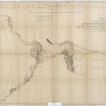 |
Map showing the territories explored by John C. Fremont on his journey from the mouth of the Kansas River to the Pacific Ocean in 1843. An elevation profile of the route is provided along the top of... |
|
MacLean & Lawrence's Sectional Map of Kansas Territory Compiled from the U.S. Surveys by C.P. Wiggin |
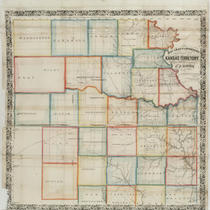 |
Map of Kansas Territory indicating counties, towns, rivers, and Native American lands. |
|
Geographically Correct Map, showing Chicago, Alton & St. Louis and Chicago, Kansas City and Denver Short Lines and Connections... |
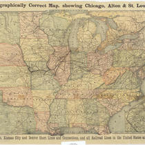 |
Map showing the service area for the Chicago, Alton & St. Louis and the Chicago, Kansas City & Denver railroads. The area includes the East Coast of the United States west to Montana, Wyoming... |
|
Tuttle Creek Reservoir - Big Blue River, Kansas |
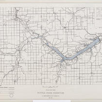 |
Map of Tuttle Creek Reservoir showing surrounding towns, roads, and proposed recreation areas. Inset map shows reservoir's location in Kansas. Reverse of map includes project data, mileage from... |
|
Lake Jacomo - Jackson County Park Department |
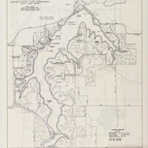 |
Two-sided map showing the area of Lake Jacomo, its nature trails, park roads, and other features of the park. |
|
United States Including Territories and Insular Possessions Showing the Extent of Public Surveys, National Parks, National Forests, Indian Reservations, National Wildlife Refuges, and Reclamation Projects |
 |
Two-sided map of the United States as well as then-territories Alaska and Hawaii, Guam, American Samoa, Puerto Rico, the United States Virgin Islands, the Panama Canal Zone, Cuba, and Pacific islands... |
|
Kansas City, Missouri; Kansas City, Kansas; and Independence, Missouri |
 |
Two-sided map of the Kansas City metropolitan area with portions dedicated to Kansas City, Missouri; Kansas City, Kansas; and Independence, Missouri. The area's streetcar lines are highlighted... |
